Murghob elevation
Murghob (Gorno-Badakhshan), Tajikistan elevation is 3607 meters and Murghob elevation in feet is 11834 ft above sea level [src 1]. Murghob is a seat of a second-order administrative division (feature code) with elevation that is 2653 meters (8704 ft) bigger than average city elevation in Tajikistan.
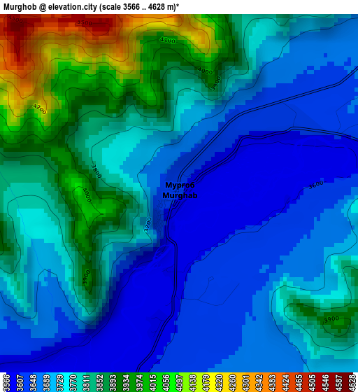
Below is the Elevation map of Murghob, which displays elevation range with different colors. Scale of the first map is from 3566 to 4628 m (11699 to 15184 ft) with average elevation of 3773.8 meters (=12381 ft) [note 1]
These maps also provides idea of topography and contour of this city, they are displayed at different zoom levels. More info about maps, scale and edge coordinates you can find below images.
| \ | Map #1 | Map #2 | Topo.Map |
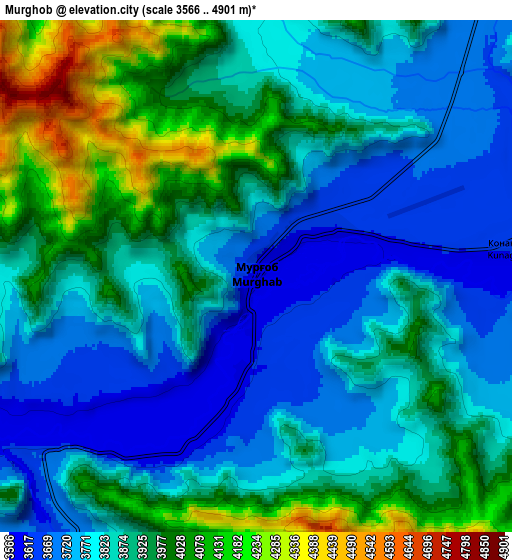
| Scale [m] | 3566..4628 m | 3566..4901 m | × |
| Scale [ft] | 11699..15184 ft | 11699..16079 ft | × |
| Average | 3773.8 m = 12381 ft | 3872.5 m = 12705 ft | × |
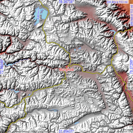
| Width | 7.68 km = 4.8 mi | 15.37 km = 9.6 mi | 245.8 km = 152.7 mi |
| Height | 7.68 km = 4.8 mi | 15.37 km = 9.6 mi | 245.8 km = 152.7 mi |
| ↑Max Latitude | 38.204771° | 38.239295° | 39.26738° |
| Latitude at center | 38.17023° | 38.17023° | 38.17023° |
| ↓Min Latitude | 38.135673° | 38.1011° | 37.05631° |
| ← Min Longitude | 73.922795° | 73.878849° | 72.56049° |
| Longitude center | 73.96674° | 73.96674° | 73.96674° |
| →Max Longitude | 74.010685° | 74.054631° | 75.37299° |
Nearby cities:
Cities around Murghob sort by population:
• Khorugh elevation 2089 m
225.1 km,  250°
250°
• Ishqoshim 2535 m
262.6 km,  232°
232°
• Mŭ’minobod 1247 m
344.1 km,  268°
268°
• Rasht 1371 m
326.4 km,  287°
287°
• Karakenja 2156 m
242.8 km,  299°
299°
• Tavildara 1618 m
308.9 km,  280°
280°
• Tajikobod 1542 m
291.5 km, 291°
• Qalaikhumb 1258 m
279 km, 276°
• Jirghatol 1837 m
267.6 km, 295°
• Vanj 1779 m
220.4 km, 275°
• Roshtqal’a 2696 m
213.9 km,  241°
241°
• Rŭshon 1990 m
212.4 km,  263°
263°
Multilingual:
 En español:
Murghob elevación 3607 m.
 En France:
Murghob élévation 3607 m.
 Auf Deutsch:
Murghob höhe über dem Meeresspiegel ist 3607 m.

Sources and notes:
- [note 1] Map square and city borders are not equal. Map elevation data is calculated only from area inside that square.
- [src 1] Elevation data from geonames database provided with same terms of usage.
- [src 2] The elevation map of Murghob is generated using elevation data from NASA's 3 arcsec (90m) resolution SRTM data.
- [src 3] Base (background) map © OpenStreetMap contributors tiles are generated by Geofabrik and OpenTopoMap.
Copyright & License:
This Murghob Elevation Map is licensed under CC BY-SA. You may reuse any part from this page, if you give a proper credit by linking to this URL:
 More info on terms of use page.