Roshtqal’a elevation
Roshtqal’a (Gorno-Badakhshan), Tajikistan elevation is 2696 meters and Roshtqal’a elevation in feet is 8845 ft above sea level [src 1]. Roshtqal’a is a seat of a second-order administrative division (feature code) with elevation that is 1742 meters (5715 ft) bigger than average city elevation in Tajikistan.
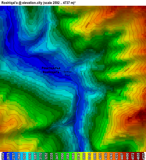
Below is the Elevation map of Roshtqal’a, which displays elevation range with different colors. Scale of the first map is from 2592 to 4737 m (8504 to 15541 ft) with average elevation of 3396.5 meters (=11143 ft) [note 1]
These maps also provides idea of topography and contour of this city, they are displayed at different zoom levels. More info about maps, scale and edge coordinates you can find below images.
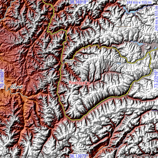
| \ | Map #1 | Topo.Map |
| Scale [m] | 2592..4737 m | × |
| Scale [ft] | 8504..15541 ft | × |
| Average | 3396.5 m = 11143 ft | × |
| Width | 7.78 km = 4.8 mi | 248.9 km = 154.7 mi |
| Height | 7.78 km = 4.8 mi | 248.9 km = 154.7 mi |
| ↑Max Latitude | 37.293239° | 38.36918° |
| Latitude at center | 37.25827° | 37.25827° |
| ↓Min Latitude | 37.223285° | 36.13073° |
| ← Min Longitude | 71.781965° | 70.41966° |
| Longitude center | 71.82591° | 71.82591° |
| →Max Longitude | 71.869855° | 73.23216° |
Nearby cities:
Cities around Roshtqal’a sort by population:
• Kŭlob elevation 609 m
194.1 km,  292°
292°
• Khorugh 2089 m
35.3 km,  316°
316°
• Ishqoshim 2535 m
62.2 km,  197°
197°
• Vose’ 472 m
201.7 km, 287°
• Chubek 514 m
191.4 km,  281°
281°
• Mŭ’minobod 1247 m
183.9 km,  300°
300°
• Moskva 486 m
199 km, 283°
• Tavildara 1618 m
198.4 km, 323°
• Shŭrobod 1979 m
169.6 km, 292°
• Qalaikhumb 1258 m
161.1 km,  325°
325°
• Vanj 1779 m
127.9 km,  345°
345°
• Rŭshon 1990 m
79.9 km,  342°
342°
Multilingual:
 En español:
Roshtqal’a elevación 2696 m.
 En France:
Roshtqal’a élévation 2696 m.
 Auf Deutsch:
Roshtqal’a höhe über dem Meeresspiegel ist 2696 m.

Sources and notes:
- [note 1] Map square and city borders are not equal. Map elevation data is calculated only from area inside that square.
- [src 1] Elevation data from geonames database provided with same terms of usage.
- [src 2] The elevation map of Roshtqal’a is generated using elevation data from NASA's 3 arcsec (90m) resolution SRTM data.
- [src 3] Base (background) map © OpenStreetMap contributors tiles are generated by Geofabrik and OpenTopoMap.
Copyright & License:
This Roshtqal’a Elevation Map is licensed under CC BY-SA. You may reuse any part from this page, if you give a proper credit by linking to this URL:
 More info on terms of use page.