Chubek elevation
Chubek (Khatlon), Tajikistan elevation is 514 meters and Chubek elevation in feet is 1686 ft above sea level [src 1]. Chubek is a populated place (feature code) with elevation that is 440 meters (1444 ft) smaller than average city elevation in Tajikistan.
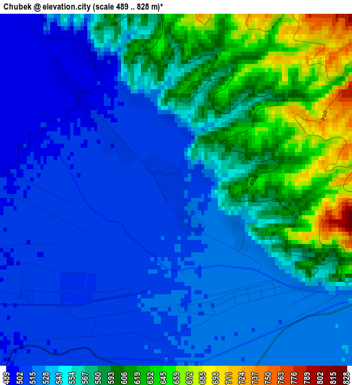
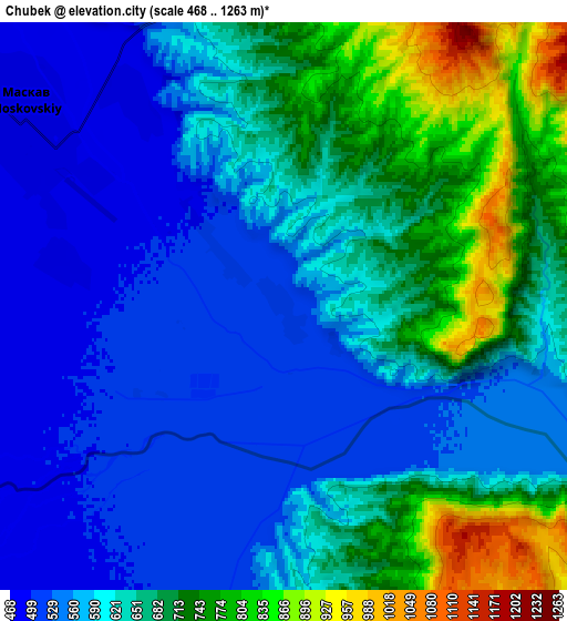
Below is the Elevation map of Chubek, which displays elevation range with different colors. Scale of the first map is from 489 to 828 m (1604 to 2717 ft) with average elevation of 553.9 meters (=1817 ft) [note 1]
These maps also provides idea of topography and contour of this city, they are displayed at different zoom levels. More info about maps, scale and edge coordinates you can find below images.
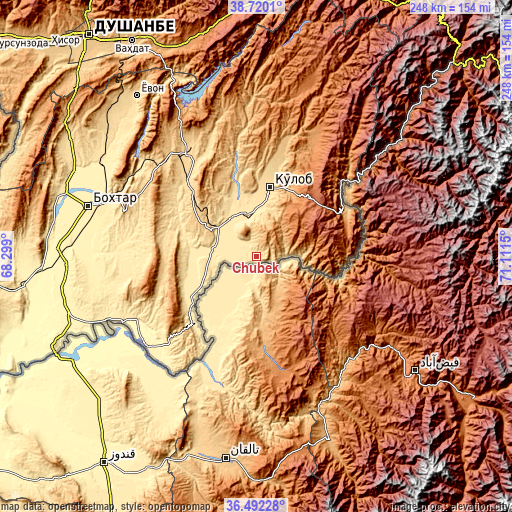
| \ | Map #1 | Map #2 | Topo.Map |
| Scale [m] | 489..828 m | 468..1263 m | × |
| Scale [ft] | 1604..2717 ft | 1535..4144 ft | × |
| Average | 553.9 m = 1817 ft | 626.9 m = 2057 ft | × |
| Width | 7.74 km = 4.8 mi | 15.48 km = 9.6 mi | 247.7 km = 153.9 mi |
| Height | 7.74 km = 4.8 mi | 15.48 km = 9.6 mi | 247.7 km = 153.9 mi |
| ↑Max Latitude | 37.649332° | 37.684119° | 38.7201° |
| Latitude at center | 37.61453° | 37.61453° | 37.61453° |
| ↓Min Latitude | 37.579711° | 37.544876° | 36.49228° |
| ← Min Longitude | 69.661305° | 69.617359° | 68.299° |
| Longitude center | 69.70525° | 69.70525° | 69.70525° |
| →Max Longitude | 69.749195° | 69.793141° | 71.1115° |
Nearby cities:
Cities around Chubek sort by population:
• Kŭlob elevation 609 m
34.1 km,  11°
11°
• Danghara 652 m
62.4 km,  329°
329°
• Farkhor 444 m
29.9 km,  242°
242°
• Vose’ 472 m
21.7 km,  345°
345°
• Vakhsh 431 m
77.4 km,  278°
278°
• Mŭ’minobod 1247 m
61.8 km,  27°
27°
• Sovet 672 m
49.1 km, 347°
• Panj 368 m
68.1 km,  231°
231°
• Baljuvon 915 m
77.2 km,  358°
358°
• Sarband 476 m
74.5 km,  292°
292°
• Shŭrobod 1979 m
39.3 km,  50°
50°
• Moskva 486 m
8.5 km,  307°
307°
Multilingual:
 En español:
Chubek elevación 514 m.
 En France:
Chubek élévation 514 m.


Sources and notes:
- [note 1] Map square and city borders are not equal. Map elevation data is calculated only from area inside that square.
- [src 1] Elevation data from geonames database provided with same terms of usage.
- [src 2] The elevation map of Chubek is generated using elevation data from NASA's 3 arcsec (90m) resolution SRTM data.
- [src 3] Base (background) map © OpenStreetMap contributors tiles are generated by Geofabrik and OpenTopoMap.
Copyright & License:
This Chubek Elevation Map is licensed under CC BY-SA. You may reuse any part from this page, if you give a proper credit by linking to this URL:
 More info on terms of use page.