Na Khu elevation
Na Khu (Kalasin), Thailand elevation is 192 meters and Na Khu elevation in feet is 630 ft above sea level [src 1]. Na Khu is a seat of a second-order administrative division (feature code) with elevation that is 67 meters (220 ft) bigger than average city elevation in Thailand.
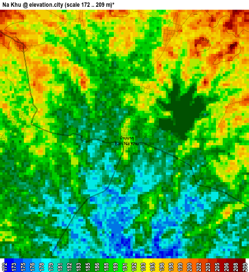
Below is the Elevation map of Na Khu, which displays elevation range with different colors. Scale of the first map is from 172 to 209 m (564 to 686 ft) with average elevation of 187.7 meters (=616 ft) [note 1]
These maps also provides idea of topography and contour of this city, they are displayed at different zoom levels. More info about maps, scale and edge coordinates you can find below images.
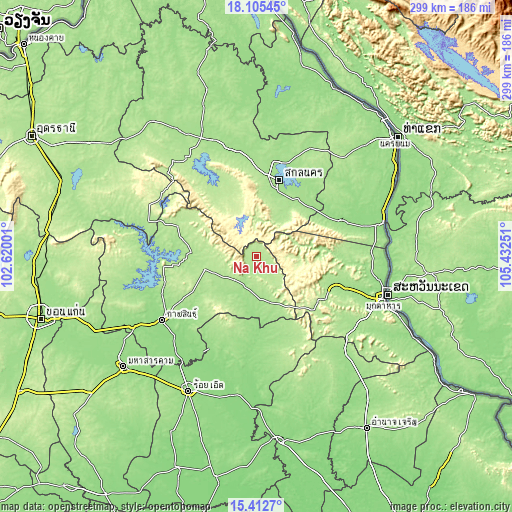
| \ | Map #1 | Topo.Map |
| Scale [m] | 172..209 m | × |
| Scale [ft] | 564..686 ft | × |
| Average | 187.7 m = 616 ft | × |
| Width | 9.36 km = 5.8 mi | 299.4 km = 186 mi |
| Height | 9.36 km = 5.8 mi | 299.4 km = 186 mi |
| ↑Max Latitude | 16.805913° | 18.10545° |
| Latitude at center | 16.76384° | 16.76384° |
| ↓Min Latitude | 16.721758° | 15.4127° |
| ← Min Longitude | 103.982315° | 102.62001° |
| Longitude center | 104.02626° | 104.02626° |
| →Max Longitude | 104.070205° | 105.43251° |
Nearby cities:
Cities around Na Khu sort by population:
• Sakon Nakhon elevation 165 m
46 km,  16°
16°
• Kuchinarai 169 m
24.9 km,  174°
174°
• Khao Wong 194 m
9.8 km,  136°
136°
• Moeiwadi 176 m
43.9 km,  161°
161°
• Kham Muang 217 m
45.5 km,  293°
293°
• Kut Bak 200 m
42.3 km,  328°
328°
• Khok Si Suphan 172 m
41 km,  40°
40°
• Na Mon 184 m
32.9 km,  230°
230°
• Somdet 199 m
30.2 km,  257°
257°
• Tao Ngoi 183 m
29.9 km,  29°
29°
• Phu Phan 288 m
26.7 km,  347°
347°
• Huai Phueng 191 m
17.7 km,  224°
224°
Multilingual:
 En español:
Na Khu elevación 192 m.
 En France:
Na Khu élévation 192 m.


Sources and notes:
- [note 1] Map square and city borders are not equal. Map elevation data is calculated only from area inside that square.
- [src 1] Elevation data from geonames database provided with same terms of usage.
- [src 2] The elevation map of Na Khu is generated using elevation data from NASA's 3 arcsec (90m) resolution SRTM data.
- [src 3] Base (background) map © OpenStreetMap contributors tiles are generated by Geofabrik and OpenTopoMap.
Copyright & License:
This Na Khu Elevation Map is licensed under CC BY-SA. You may reuse any part from this page, if you give a proper credit by linking to this URL:
 More info on terms of use page.