Somdet elevation
Somdet (Kalasin), Thailand elevation is 199 meters and Somdet elevation in feet is 653 ft above sea level [src 1]. Somdet is a seat of a second-order administrative division (feature code) with elevation that is 74 meters (243 ft) bigger than average city elevation in Thailand.
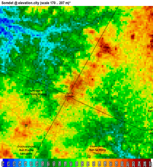
Below is the Elevation map of Somdet, which displays elevation range with different colors. Scale of the first map is from 170 to 207 m (558 to 679 ft) with average elevation of 187.9 meters (=616 ft) [note 1]
These maps also provides idea of topography and contour of this city, they are displayed at different zoom levels. More info about maps, scale and edge coordinates you can find below images.
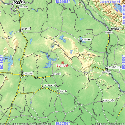
| \ | Map #1 | Topo.Map |
| Scale [m] | 170..207 m | × |
| Scale [ft] | 558..679 ft | × |
| Average | 187.9 m = 616 ft | × |
| Width | 9.36 km = 5.8 mi | 299.5 km = 186.1 mi |
| Height | 9.36 km = 5.8 mi | 299.5 km = 186.1 mi |
| ↑Max Latitude | 16.746706° | 18.04666° |
| Latitude at center | 16.70462° | 16.70462° |
| ↓Min Latitude | 16.662525° | 15.35308° |
| ← Min Longitude | 103.705405° | 102.3431° |
| Longitude center | 103.74935° | 103.74935° |
| →Max Longitude | 103.793295° | 105.1556° |
Nearby cities:
Cities around Somdet sort by population:
• Kalasin elevation 152 m
39.8 km,  220°
220°
• Kuchinarai 169 m
36.8 km,  119°
119°
• Khao Wong 194 m
36.3 km,  90°
90°
• Phu Phan 288 m
40.5 km,  36°
36°
• Na Khu 192 m
30.2 km,  77°
77°
• Samran 197 m
28.3 km,  308°
308°
• Sam Chai 197 m
28.3 km, 308°
• Don Chan 174 m
28.1 km,  191°
191°
• Kham Muang 217 m
27.8 km,  334°
334°
• Sahatsakhan 202 m
24.4 km,  272°
272°
• Huai Phueng 191 m
18.1 km,  109°
109°
• Na Mon 184 m
14.8 km,  164°
164°
Multilingual:
 En español:
Somdet elevación 199 m.
 En France:
Somdet élévation 199 m.


Sources and notes:
- [note 1] Map square and city borders are not equal. Map elevation data is calculated only from area inside that square.
- [src 1] Elevation data from geonames database provided with same terms of usage.
- [src 2] The elevation map of Somdet is generated using elevation data from NASA's 3 arcsec (90m) resolution SRTM data.
- [src 3] Base (background) map © OpenStreetMap contributors tiles are generated by Geofabrik and OpenTopoMap.
Copyright & License:
This Somdet Elevation Map is licensed under CC BY-SA. You may reuse any part from this page, if you give a proper credit by linking to this URL:
 More info on terms of use page.