Nang Rong elevation
Nang Rong (Buriram), Thailand elevation is 192 meters and Nang Rong elevation in feet is 630 ft above sea level [src 1]. Nang Rong is a seat of a second-order administrative division (feature code) with elevation that is 67 meters (220 ft) bigger than average city elevation in Thailand.
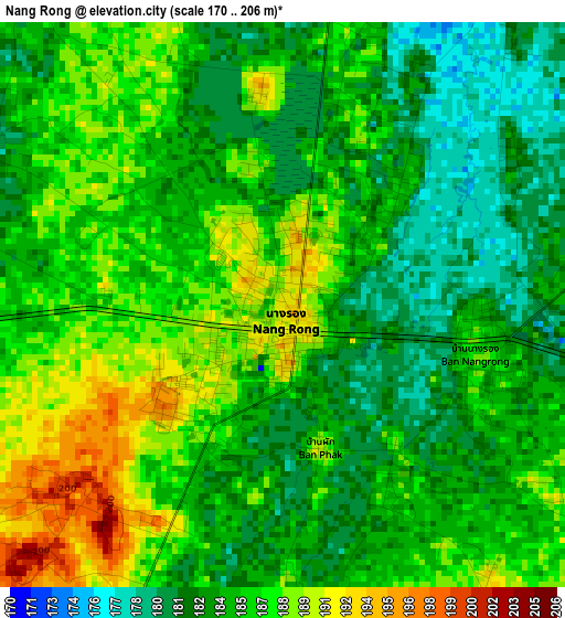
Below is the Elevation map of Nang Rong, which displays elevation range with different colors. Scale of the first map is from 170 to 206 m (558 to 676 ft) with average elevation of 185 meters (=607 ft) [note 1]
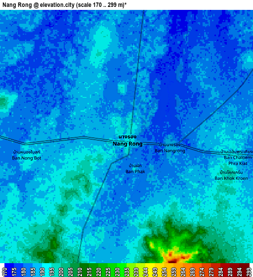
These maps also provides idea of topography and contour of this city, they are displayed at different zoom levels. More info about maps, scale and edge coordinates you can find below images.
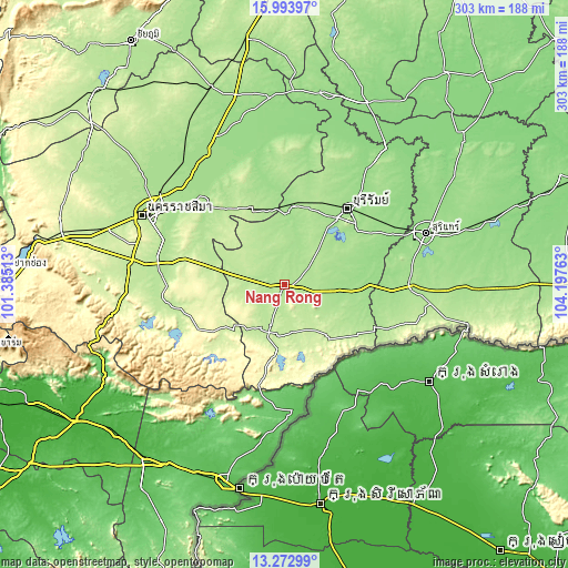
| \ | Map #1 | Map #2 | Topo.Map |
| Scale [m] | 170..206 m | 170..299 m | × |
| Scale [ft] | 558..676 ft | 558..981 ft | × |
| Average | 185 m = 607 ft | 187.3 m = 615 ft | × |
| Width | 9.46 km = 5.9 mi | 18.91 km = 11.8 mi | 302.5 km = 188 mi |
| Height | 9.46 km = 5.9 mi | 18.91 km = 11.8 mi | 302.6 km = 188 mi |
| ↑Max Latitude | 14.680215° | 14.722721° | 15.99397° |
| Latitude at center | 14.6377° | 14.6377° | 14.6377° |
| ↓Min Latitude | 14.595177° | 14.552646° | 13.27299° |
| ← Min Longitude | 102.747435° | 102.703489° | 101.38513° |
| Longitude center | 102.79138° | 102.79138° | 102.79138° |
| →Max Longitude | 102.835325° | 102.879271° | 104.19763° |
Nearby cities:
Cities around Nang Rong sort by population:
• Prakhon Chai elevation 166 m
35.6 km,  95°
95°
• Nong Ki 219 m
27.8 km,  281°
281°
• Ban Kruat 195 m
40.9 km,  125°
125°
• Non Din Daeng 245 m
36.3 km,  187°
187°
• Prakhon Chai 165 m
31.1 km, 95°
• Lahan Sai 216 m
26.2 km,  163°
163°
• Nong Hong 189 m
26.1 km,  333°
333°
• Pakham 208 m
23.3 km,  197°
197°
• Pa Kham 208 m
23.3 km, 197°
• Non Suwan 223 m
21.9 km,  253°
253°
• Chamni 176 m
16.9 km,  11°
11°
• Chaloem Phra Kiat 203 m
16.8 km,  121°
121°
Multilingual:
 En español:
Nang Rong elevación 192 m.
 En France:
Nang Rong élévation 192 m.
 Auf Deutsch:
Nang Rong höhe über dem Meeresspiegel ist 192 m.

Sources and notes:
- [note 1] Map square and city borders are not equal. Map elevation data is calculated only from area inside that square.
- [src 1] Elevation data from geonames database provided with same terms of usage.
- [src 2] The elevation map of Nang Rong is generated using elevation data from NASA's 3 arcsec (90m) resolution SRTM data.
- [src 3] Base (background) map © OpenStreetMap contributors tiles are generated by Geofabrik and OpenTopoMap.
Copyright & License:
This Nang Rong Elevation Map is licensed under CC BY-SA. You may reuse any part from this page, if you give a proper credit by linking to this URL:
 More info on terms of use page.