Nong Hong elevation
Nong Hong (Buriram), Thailand elevation is 189 meters and Nong Hong elevation in feet is 620 ft above sea level [src 1]. Nong Hong is a seat of a second-order administrative division (feature code) with elevation that is 64 meters (210 ft) bigger than average city elevation in Thailand.
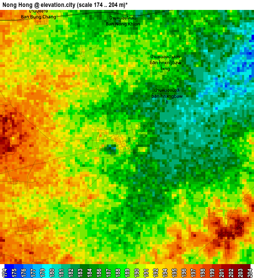
Below is the Elevation map of Nong Hong, which displays elevation range with different colors. Scale of the first map is from 174 to 204 m (571 to 669 ft) with average elevation of 189 meters (=620 ft) [note 1]
These maps also provides idea of topography and contour of this city, they are displayed at different zoom levels. More info about maps, scale and edge coordinates you can find below images.
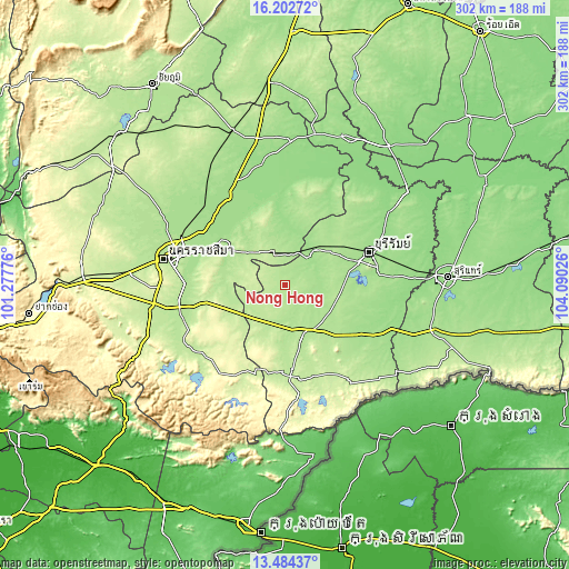
| \ | Map #1 | Topo.Map |
| Scale [m] | 174..204 m | × |
| Scale [ft] | 571..669 ft | × |
| Average | 189 m = 620 ft | × |
| Width | 9.45 km = 5.9 mi | 302.3 km = 187.8 mi |
| Height | 9.45 km = 5.9 mi | 302.3 km = 187.8 mi |
| ↑Max Latitude | 14.890294° | 16.20272° |
| Latitude at center | 14.84782° | 14.84782° |
| ↓Min Latitude | 14.805338° | 13.48437° |
| ← Min Longitude | 102.640065° | 101.27776° |
| Longitude center | 102.68401° | 102.68401° |
| →Max Longitude | 102.727955° | 104.09026° |
Nearby cities:
Cities around Nong Hong sort by population:
• Nang Rong elevation 192 m
26.1 km,  153°
153°
• Ban Huai Thalaeng 195 m
15.5 km,  346°
346°
• Nong Ki 219 m
23.8 km,  221°
221°
• Pakham 208 m
45.8 km,  174°
174°
• Pa Kham 208 m
45.8 km, 174°
• Chaloem Phra Kiat 203 m
41.3 km,  141°
141°
• Nong Bun Nak 262 m
36.3 km,  250°
250°
• Chakkarat 176 m
34.5 km,  302°
302°
• Non Suwan 223 m
31.2 km,  197°
197°
• Lam Plai Mat 169 m
25.8 km,  40°
40°
• Huai Thalaeng 196 m
17 km, 346°
• Chamni 176 m
16.4 km,  114°
114°
Multilingual:
 En español:
Nong Hong elevación 189 m.
 En France:
Nong Hong élévation 189 m.
 Auf Deutsch:
Nong Hong höhe über dem Meeresspiegel ist 189 m.

Sources and notes:
- [note 1] Map square and city borders are not equal. Map elevation data is calculated only from area inside that square.
- [src 1] Elevation data from geonames database provided with same terms of usage.
- [src 2] The elevation map of Nong Hong is generated using elevation data from NASA's 3 arcsec (90m) resolution SRTM data.
- [src 3] Base (background) map © OpenStreetMap contributors tiles are generated by Geofabrik and OpenTopoMap.
Copyright & License:
This Nong Hong Elevation Map is licensed under CC BY-SA. You may reuse any part from this page, if you give a proper credit by linking to this URL:
 More info on terms of use page.