Prakhon Chai elevation
Prakhon Chai (Buriram), Thailand elevation is 166 meters and Prakhon Chai elevation in feet is 545 ft above sea level [src 1]. Prakhon Chai is a populated place (feature code) with elevation that is 41 meters (135 ft) bigger than average city elevation in Thailand.
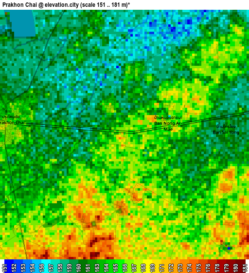
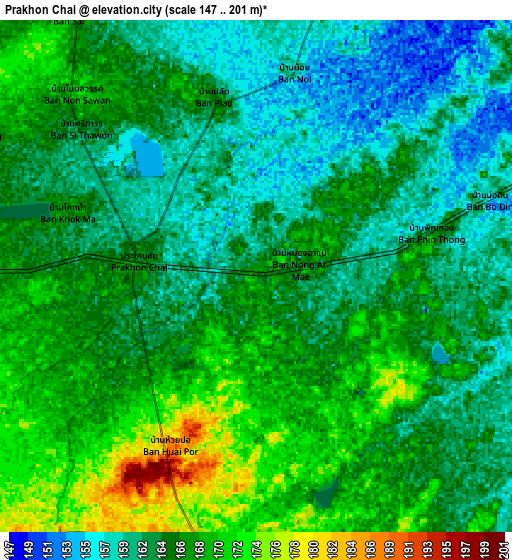
Below is the Elevation map of Prakhon Chai, which displays elevation range with different colors. Scale of the first map is from 151 to 181 m (495 to 594 ft) with average elevation of 163.4 meters (=536 ft) [note 1]
These maps also provides idea of topography and contour of this city, they are displayed at different zoom levels. More info about maps, scale and edge coordinates you can find below images.
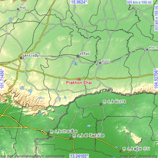
| \ | Map #1 | Map #2 | Topo.Map |
| Scale [m] | 151..181 m | 147..201 m | × |
| Scale [ft] | 495..594 ft | 482..659 ft | × |
| Average | 163.4 m = 536 ft | 164.6 m = 540 ft | × |
| Width | 9.46 km = 5.9 mi | 18.91 km = 11.8 mi | 302.6 km = 188 mi |
| Height | 9.46 km = 5.9 mi | 18.91 km = 11.8 mi | 302.6 km = 188 mi |
| ↑Max Latitude | 14.648441° | 14.690954° | 15.9624° |
| Latitude at center | 14.60592° | 14.60592° | 14.60592° |
| ↓Min Latitude | 14.563391° | 14.520853° | 13.24102° |
| ← Min Longitude | 103.076865° | 103.032919° | 101.71456° |
| Longitude center | 103.12081° | 103.12081° | 103.12081° |
| →Max Longitude | 103.164755° | 103.208701° | 104.52706° |
Nearby cities:
Cities around Prakhon Chai sort by population:
• Buri Ram elevation 158 m
43.2 km,  357°
357°
• Nang Rong 192 m
35.6 km,  275°
275°
• Krasang 155 m
40.4 km,  29°
29°
• Huai Rat 162 m
40.1 km,  10°
10°
• Chamni 176 m
37.8 km,  302°
302°
• Lahan Sai 216 m
35.5 km,  232°
232°
• Prasat 171 m
30.8 km,  82°
82°
• Phanom Dong Rak 193 m
26.7 km,  131°
131°
• Chaloem Phra Kiat 203 m
21.7 km,  255°
255°
• Ban Kruat 195 m
20.5 km,  186°
186°
• Phlapphla Chai 161 m
14.7 km,  19°
19°
• Prakhon Chai 165 m
4.5 km, 276°
Multilingual:
 En español:
Prakhon Chai elevación 166 m.
 En France:
Prakhon Chai élévation 166 m.
 Auf Deutsch:
Prakhon Chai höhe über dem Meeresspiegel ist 166 m.

Sources and notes:
- [note 1] Map square and city borders are not equal. Map elevation data is calculated only from area inside that square.
- [src 1] Elevation data from geonames database provided with same terms of usage.
- [src 2] The elevation map of Prakhon Chai is generated using elevation data from NASA's 3 arcsec (90m) resolution SRTM data.
- [src 3] Base (background) map © OpenStreetMap contributors tiles are generated by Geofabrik and OpenTopoMap.
Copyright & License:
This Prakhon Chai Elevation Map is licensed under CC BY-SA. You may reuse any part from this page, if you give a proper credit by linking to this URL:
 More info on terms of use page.