Pak Chong elevation
Pak Chong (Nakhon Ratchasima), Thailand elevation is 307 meters and Pak Chong elevation in feet is 1007 ft above sea level [src 1]. Pak Chong is a seat of a second-order administrative division (feature code) with elevation that is 182 meters (597 ft) bigger than average city elevation in Thailand.
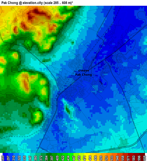
Below is the Elevation map of Pak Chong, which displays elevation range with different colors. Scale of the first map is from 285 to 608 m (935 to 1995 ft) with average elevation of 352.8 meters (=1157 ft) [note 1]
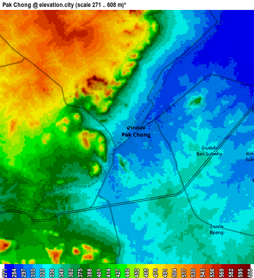
These maps also provides idea of topography and contour of this city, they are displayed at different zoom levels. More info about maps, scale and edge coordinates you can find below images.
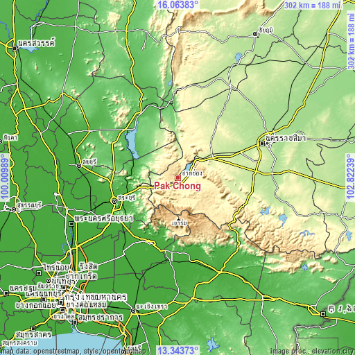
| \ | Map #1 | Map #2 | Topo.Map |
| Scale [m] | 285..608 m | 271..608 m | × |
| Scale [ft] | 935..1995 ft | 889..1995 ft | × |
| Average | 352.8 m = 1157 ft | 378.6 m = 1242 ft | × |
| Width | 9.45 km = 5.9 mi | 18.9 km = 11.7 mi | 302.4 km = 187.9 mi |
| Height | 9.45 km = 5.9 mi | 18.9 km = 11.7 mi | 302.5 km = 188 mi |
| ↑Max Latitude | 14.750521° | 14.793014° | 16.06383° |
| Latitude at center | 14.70802° | 14.70802° | 14.70802° |
| ↓Min Latitude | 14.665511° | 14.622993° | 13.34373° |
| ← Min Longitude | 101.372195° | 101.328249° | 100.00989° |
| Longitude center | 101.41614° | 101.41614° | 101.41614° |
| →Max Longitude | 101.460085° | 101.504031° | 102.82239° |
Nearby cities:
Cities around Pak Chong sort by population:
• Saraburi elevation 22 m
57.1 km,  250°
250°
• Kaeng Khoi 23 m
47 km, 253°
• Amphoe Sikhiu 232 m
37.9 km,  55°
55°
• Nakhon Nayok 12 m
60.1 km,  201°
201°
• Sung Noen 216 m
48.4 km, 63°
• Wang Nam Khiao 418 m
57.7 km,  123°
123°
• Chaloem Phra Kiat 27 m
55.7 km,  258°
258°
• Tha Luang 58 m
52.9 km,  319°
319°
• Phatthana Nikhom 46 m
49.2 km,  289°
289°
• Sikhio 238 m
38.8 km, 58°
• Wang Muang 70 m
34.6 km,  295°
295°
• Muak Lek 221 m
24 km, 255°
Multilingual:
 En español:
Pak Chong elevación 307 m.
 En France:
Pak Chong élévation 307 m.
 Auf Deutsch:
Pak Chong höhe über dem Meeresspiegel ist 307 m.

Sources and notes:
- [note 1] Map square and city borders are not equal. Map elevation data is calculated only from area inside that square.
- [src 1] Elevation data from geonames database provided with same terms of usage.
- [src 2] The elevation map of Pak Chong is generated using elevation data from NASA's 3 arcsec (90m) resolution SRTM data.
- [src 3] Base (background) map © OpenStreetMap contributors tiles are generated by Geofabrik and OpenTopoMap.
Copyright & License:
This Pak Chong Elevation Map is licensed under CC BY-SA. You may reuse any part from this page, if you give a proper credit by linking to this URL:
 More info on terms of use page.