Sung Noen elevation
Sung Noen (Nakhon Ratchasima), Thailand elevation is 216 meters and Sung Noen elevation in feet is 709 ft above sea level [src 1]. Sung Noen is a seat of a second-order administrative division (feature code) with elevation that is 91 meters (299 ft) bigger than average city elevation in Thailand.
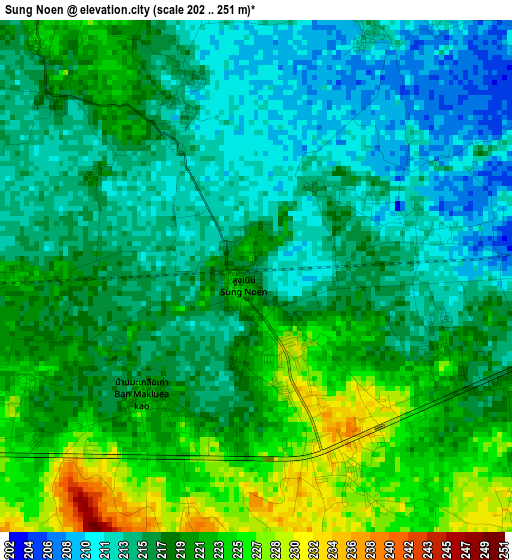
Below is the Elevation map of Sung Noen, which displays elevation range with different colors. Scale of the first map is from 202 to 251 m (663 to 823 ft) with average elevation of 217.7 meters (=714 ft) [note 1]
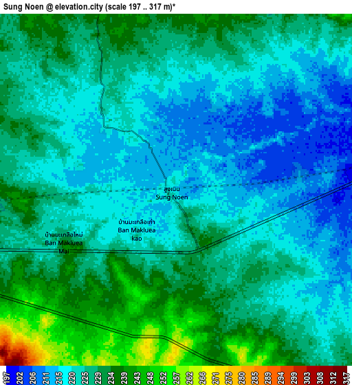
These maps also provides idea of topography and contour of this city, they are displayed at different zoom levels. More info about maps, scale and edge coordinates you can find below images.
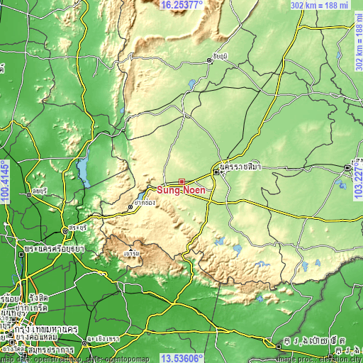
| \ | Map #1 | Map #2 | Topo.Map |
| Scale [m] | 202..251 m | 197..317 m | × |
| Scale [ft] | 663..823 ft | 646..1040 ft | × |
| Average | 217.7 m = 714 ft | 225.3 m = 739 ft | × |
| Width | 9.44 km = 5.9 mi | 18.89 km = 11.7 mi | 302.2 km = 187.8 mi |
| Height | 9.44 km = 5.9 mi | 18.89 km = 11.7 mi | 302.2 km = 187.8 mi |
| ↑Max Latitude | 14.941664° | 14.984119° | 16.25377° |
| Latitude at center | 14.8992° | 14.8992° | 14.8992° |
| ↓Min Latitude | 14.856728° | 14.814248° | 13.53606° |
| ← Min Longitude | 101.776805° | 101.732859° | 100.4145° |
| Longitude center | 101.82075° | 101.82075° | 101.82075° |
| →Max Longitude | 101.864695° | 101.908641° | 103.227° |
Nearby cities:
Cities around Sung Noen sort by population:
• Nakhon Ratchasima elevation 187 m
31.2 km,  75°
75°
• Pak Chong 307 m
48.4 km,  243°
243°
• Amphoe Sikhiu 232 m
12.1 km,  270°
270°
• Chok Chai 195 m
41.6 km,  117°
117°
• Dan Khun Thot 214 m
34.8 km,  351°
351°
• Non Thai 177 m
42.6 km,  39°
39°
• Wang Nam Khiao 418 m
53.7 km,  175°
175°
• Chaloem Phra Kiat 165 m
49.7 km, 76°
• Phra Thong Kham 190 m
46.2 km,  27°
27°
• Pak Thong Chai 207 m
29.5 km,  131°
131°
• Kham Thale So 211 m
15.3 km,  63°
63°
• Sikhio 238 m
10.5 km, 265°
Multilingual:
 En español:
Sung Noen elevación 216 m.
 En France:
Sung Noen élévation 216 m.
 Auf Deutsch:
Sung Noen höhe über dem Meeresspiegel ist 216 m.

Sources and notes:
- [note 1] Map square and city borders are not equal. Map elevation data is calculated only from area inside that square.
- [src 1] Elevation data from geonames database provided with same terms of usage.
- [src 2] The elevation map of Sung Noen is generated using elevation data from NASA's 3 arcsec (90m) resolution SRTM data.
- [src 3] Base (background) map © OpenStreetMap contributors tiles are generated by Geofabrik and OpenTopoMap.
Copyright & License:
This Sung Noen Elevation Map is licensed under CC BY-SA. You may reuse any part from this page, if you give a proper credit by linking to this URL:
 More info on terms of use page.