Phon elevation
Phon (Khon Kaen), Thailand elevation is 177 meters and Phon elevation in feet is 581 ft above sea level [src 1]. Phon is a seat of a second-order administrative division (feature code) with elevation that is 52 meters (171 ft) bigger than average city elevation in Thailand.
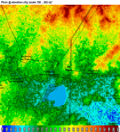
Below is the Elevation map of Phon, which displays elevation range with different colors. Scale of the first map is from 158 to 202 m (518 to 663 ft) with average elevation of 178.1 meters (=584 ft) [note 1]
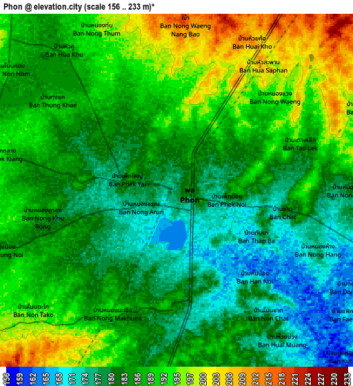
These maps also provides idea of topography and contour of this city, they are displayed at different zoom levels. More info about maps, scale and edge coordinates you can find below images.
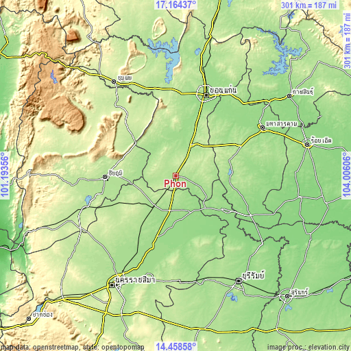
| \ | Map #1 | Map #2 | Topo.Map |
| Scale [m] | 158..202 m | 156..233 m | × |
| Scale [ft] | 518..663 ft | 512..764 ft | × |
| Average | 178.1 m = 584 ft | 185.3 m = 608 ft | × |
| Width | 9.4 km = 5.8 mi | 18.81 km = 11.7 mi | 300.9 km = 187 mi |
| Height | 9.4 km = 5.8 mi | 18.81 km = 11.7 mi | 300.9 km = 187 mi |
| ↑Max Latitude | 15.858277° | 15.900546° | 17.16437° |
| Latitude at center | 15.816° | 15.816° | 15.816° |
| ↓Min Latitude | 15.773714° | 15.731419° | 14.45858° |
| ← Min Longitude | 102.555865° | 102.511919° | 101.19356° |
| Longitude center | 102.59981° | 102.59981° | 102.59981° |
| →Max Longitude | 102.643755° | 102.687701° | 104.00606° |
Nearby cities:
Cities around Phon sort by population:
• Ban Phai elevation 174 m
30.5 km,  27°
27°
• Bua Yai 177 m
31.7 km,  215°
215°
• Pueai Noi 196 m
33.5 km,  79°
79°
• Khon Sawan 189 m
36.4 km,  290°
290°
• Mancha Khiri 168 m
35.6 km,  349°
349°
• Prathai 157 m
34.1 km,  157°
157°
• Chonnabot 168 m
30.4 km,  4°
4°
• Sida 164 m
29.8 km,  186°
186°
• Bua Lai 196 m
19.9 km,  212°
212°
• Waeng Noi 197 m
19.7 km,  265°
265°
• Non Sila 202 m
19.1 km,  23°
23°
• Waeng Yai 193 m
16.5 km,  339°
339°
Multilingual:
 En español:
Phon elevación 177 m.
 En France:
Phon élévation 177 m.


Sources and notes:
- [note 1] Map square and city borders are not equal. Map elevation data is calculated only from area inside that square.
- [src 1] Elevation data from geonames database provided with same terms of usage.
- [src 2] The elevation map of Phon is generated using elevation data from NASA's 3 arcsec (90m) resolution SRTM data.
- [src 3] Base (background) map © OpenStreetMap contributors tiles are generated by Geofabrik and OpenTopoMap.
Copyright & License:
This Phon Elevation Map is licensed under CC BY-SA. You may reuse any part from this page, if you give a proper credit by linking to this URL:
 More info on terms of use page.