Bua Yai elevation
Bua Yai (Nakhon Ratchasima), Thailand elevation is 177 meters and Bua Yai elevation in feet is 581 ft above sea level [src 1]. Bua Yai is a seat of a second-order administrative division (feature code) with elevation that is 52 meters (171 ft) bigger than average city elevation in Thailand.
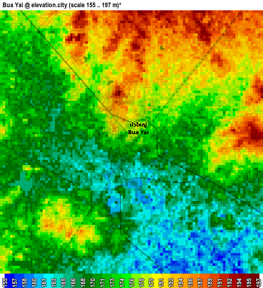
Below is the Elevation map of Bua Yai, which displays elevation range with different colors. Scale of the first map is from 155 to 197 m (509 to 646 ft) with average elevation of 173.7 meters (=570 ft) [note 1]
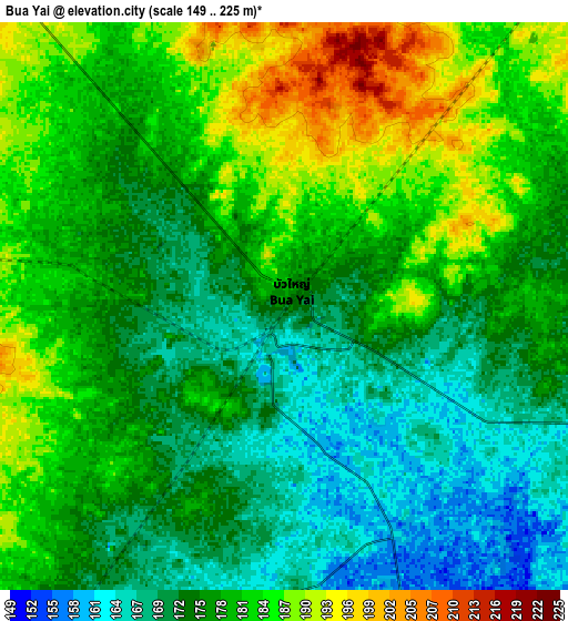
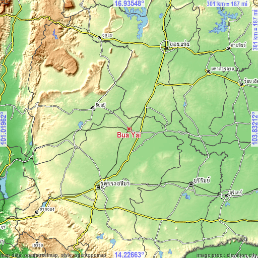
These maps also provides idea of topography and contour of this city, they are displayed at different zoom levels. More info about maps, scale and edge coordinates you can find below images.
| \ | Map #1 | Map #2 | Topo.Map |
| Scale [m] | 155..197 m | 149..225 m | × |
| Scale [ft] | 509..646 ft | 489..738 ft | × |
| Average | 173.7 m = 570 ft | 177.9 m = 584 ft | × |
| Width | 9.41 km = 5.8 mi | 18.83 km = 11.7 mi | 301.2 km = 187.2 mi |
| Height | 9.41 km = 5.8 mi | 18.83 km = 11.7 mi | 301.2 km = 187.2 mi |
| ↑Max Latitude | 15.627845° | 15.670161° | 16.93548° |
| Latitude at center | 15.58552° | 15.58552° | 15.58552° |
| ↓Min Latitude | 15.543186° | 15.500844° | 14.22663° |
| ← Min Longitude | 102.381925° | 102.337979° | 101.01962° |
| Longitude center | 102.42587° | 102.42587° | 102.42587° |
| →Max Longitude | 102.469815° | 102.513761° | 103.83212° |
Nearby cities:
Cities around Bua Yai sort by population:
• Phon elevation 177 m
31.7 km,  35°
35°
• Phimai 157 m
41 km,  169°
169°
• Kham Sakae Saeng 189 m
39.1 km,  223°
223°
• Khon Sawan 189 m
41.5 km,  338°
338°
• Prathai 157 m
32.3 km,  100°
100°
• Ban Lueam 194 m
31.9 km,  274°
274°
• Kaeng Sanam Nang 182 m
25.8 km,  314°
314°
• Waeng Noi 197 m
24.3 km,  357°
357°
• Non Daeng 162 m
23 km,  147°
147°
• Khong 178 m
18.9 km,  213°
213°
• Sida 164 m
15.6 km, 104°
• Bua Lai 196 m
11.8 km, 41°
Multilingual:
 En español:
Bua Yai elevación 177 m.
 En France:
Bua Yai élévation 177 m.


Sources and notes:
- [note 1] Map square and city borders are not equal. Map elevation data is calculated only from area inside that square.
- [src 1] Elevation data from geonames database provided with same terms of usage.
- [src 2] The elevation map of Bua Yai is generated using elevation data from NASA's 3 arcsec (90m) resolution SRTM data.
- [src 3] Base (background) map © OpenStreetMap contributors tiles are generated by Geofabrik and OpenTopoMap.
Copyright & License:
This Bua Yai Elevation Map is licensed under CC BY-SA. You may reuse any part from this page, if you give a proper credit by linking to this URL:
 More info on terms of use page.