Ban Phai elevation
Ban Phai (Khon Kaen), Thailand elevation is 174 meters and Ban Phai elevation in feet is 571 ft above sea level [src 1]. Ban Phai is a seat of a second-order administrative division (feature code) with elevation that is 49 meters (161 ft) bigger than average city elevation in Thailand.
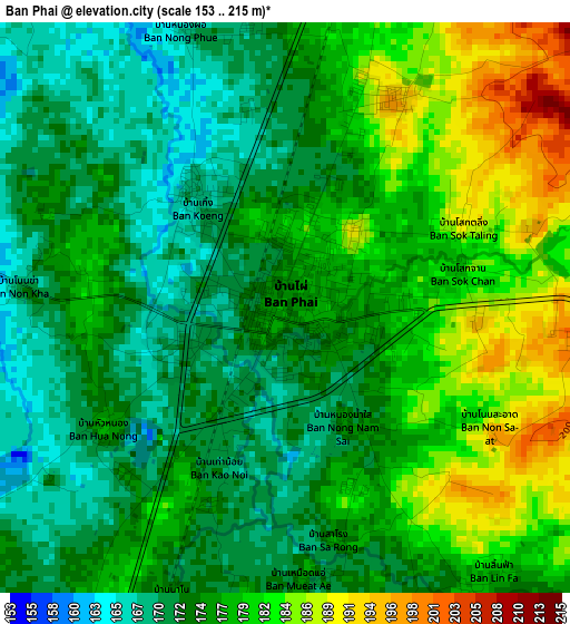
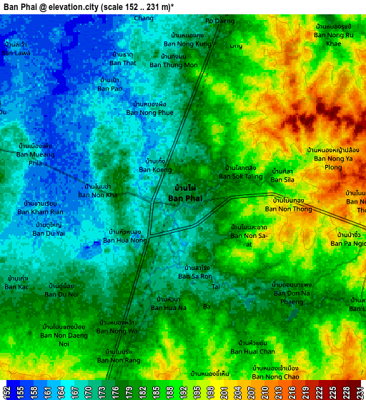
Below is the Elevation map of Ban Phai, which displays elevation range with different colors. Scale of the first map is from 153 to 215 m (502 to 705 ft) with average elevation of 176.5 meters (=579 ft) [note 1]
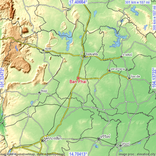
These maps also provides idea of topography and contour of this city, they are displayed at different zoom levels. More info about maps, scale and edge coordinates you can find below images.
| \ | Map #1 | Map #2 | Topo.Map |
| Scale [m] | 153..215 m | 152..231 m | × |
| Scale [ft] | 502..705 ft | 499..758 ft | × |
| Average | 176.5 m = 579 ft | 180.7 m = 593 ft | × |
| Width | 9.39 km = 5.8 mi | 18.78 km = 11.7 mi | 300.5 km = 186.7 mi |
| Height | 9.39 km = 5.8 mi | 18.78 km = 11.7 mi | 300.5 km = 186.7 mi |
| ↑Max Latitude | 16.102196° | 16.144413° | 17.40664° |
| Latitude at center | 16.05997° | 16.05997° | 16.05997° |
| ↓Min Latitude | 16.017735° | 15.975492° | 14.70413° |
| ← Min Longitude | 102.687025° | 102.643079° | 101.32472° |
| Longitude center | 102.73097° | 102.73097° | 102.73097° |
| →Max Longitude | 102.774915° | 102.818861° | 104.13722° |
Nearby cities:
Cities around Ban Phai sort by population:
• Phon elevation 177 m
30.5 km,  207°
207°
• Kosum Phisai 160 m
41.6 km,  59°
59°
• Pueai Noi 196 m
28.4 km,  138°
138°
• Borabue 180 m
41.1 km,  92°
92°
• Khok Pho Chai 190 m
35.6 km,  274°
274°
• Phra Yuen 178 m
31.1 km,  344°
344°
• Kut Rang 162 m
30 km,  82°
82°
• Waeng Yai 193 m
22.8 km,  239°
239°
• Mancha Khiri 168 m
22.1 km,  290°
290°
• Ban Haet 169 m
15.5 km,  11°
11°
• Chonnabot 168 m
12.1 km, 285°
• Non Sila 202 m
11.5 km, 214°
Multilingual:
 En español:
Ban Phai elevación 174 m.
 En France:
Ban Phai élévation 174 m.
 Auf Deutsch:
Ban Phai höhe über dem Meeresspiegel ist 174 m.

Sources and notes:
- [note 1] Map square and city borders are not equal. Map elevation data is calculated only from area inside that square.
- [src 1] Elevation data from geonames database provided with same terms of usage.
- [src 2] The elevation map of Ban Phai is generated using elevation data from NASA's 3 arcsec (90m) resolution SRTM data.
- [src 3] Base (background) map © OpenStreetMap contributors tiles are generated by Geofabrik and OpenTopoMap.
Copyright & License:
This Ban Phai Elevation Map is licensed under CC BY-SA. You may reuse any part from this page, if you give a proper credit by linking to this URL:
 More info on terms of use page.