Tha Tako elevation
Tha Tako (Nakhon Sawan), Thailand elevation is 36 meters and Tha Tako elevation in feet is 118 ft above sea level [src 1]. Tha Tako is a seat of a second-order administrative division (feature code) with elevation that is 89 meters (292 ft) smaller than average city elevation in Thailand.
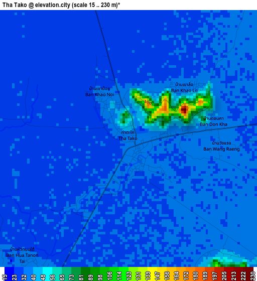
Below is the Elevation map of Tha Tako, which displays elevation range with different colors. Scale of the first map is from 15 to 230 m (49 to 755 ft) with average elevation of 33.9 meters (=111 ft) [note 1]
These maps also provides idea of topography and contour of this city, they are displayed at different zoom levels. More info about maps, scale and edge coordinates you can find below images.
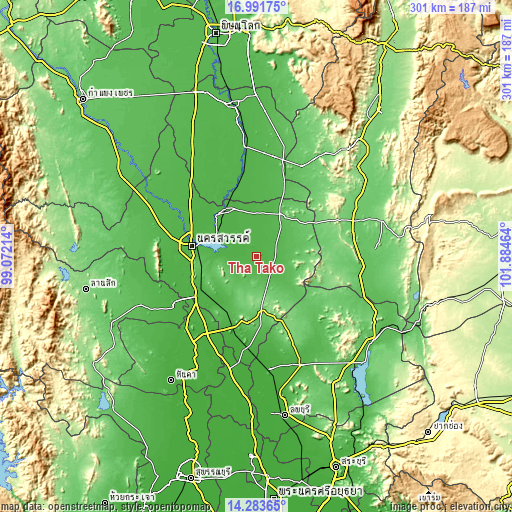
| \ | Map #1 | Topo.Map |
| Scale [m] | 15..230 m | × |
| Scale [ft] | 49..755 ft | × |
| Average | 33.9 m = 111 ft | × |
| Width | 9.41 km = 5.8 mi | 301.1 km = 187.1 mi |
| Height | 9.41 km = 5.8 mi | 301.1 km = 187.1 mi |
| ↑Max Latitude | 15.684493° | 16.99175° |
| Latitude at center | 15.64218° | 15.64218° |
| ↓Min Latitude | 15.599858° | 14.28365° |
| ← Min Longitude | 100.434445° | 99.07214° |
| Longitude center | 100.47839° | 100.47839° |
| →Max Longitude | 100.522335° | 101.88464° |
Nearby cities:
Cities around Tha Tako sort by population:
• Nakhon Sawan elevation 31 m
37.2 km,  280°
280°
• Bang Mun Nak 33 m
44.2 km,  346°
346°
• Nong Bua 43 m
27.3 km,  24°
24°
• Phai Sali 55 m
18.9 km,  104°
104°
• Phayuha Khiri 27 m
42.2 km,  240°
240°
• Nong Muang 119 m
48 km,  156°
156°
• Khok Charoen 77 m
46.7 km,  128°
128°
• Dong Charoen 60 m
46.5 km,  25°
25°
• Krok Phra 26 m
44.6 km,  257°
257°
• Takhli 34 m
44.5 km,  198°
198°
• Chumsaeng 32 m
33.2 km,  326°
326°
• Tak Fa 91 m
32.6 km,  176°
176°
Multilingual:
 En español:
Tha Tako elevación 36 m.
 En France:
Tha Tako élévation 36 m.


Sources and notes:
- [note 1] Map square and city borders are not equal. Map elevation data is calculated only from area inside that square.
- [src 1] Elevation data from geonames database provided with same terms of usage.
- [src 2] The elevation map of Tha Tako is generated using elevation data from NASA's 3 arcsec (90m) resolution SRTM data.
- [src 3] Base (background) map © OpenStreetMap contributors tiles are generated by Geofabrik and OpenTopoMap.
Copyright & License:
This Tha Tako Elevation Map is licensed under CC BY-SA. You may reuse any part from this page, if you give a proper credit by linking to this URL:
 More info on terms of use page.