Takhli elevation
Takhli (Nakhon Sawan), Thailand elevation is 34 meters and Takhli elevation in feet is 112 ft above sea level [src 1]. Takhli is a seat of a second-order administrative division (feature code) with elevation that is 91 meters (299 ft) smaller than average city elevation in Thailand.
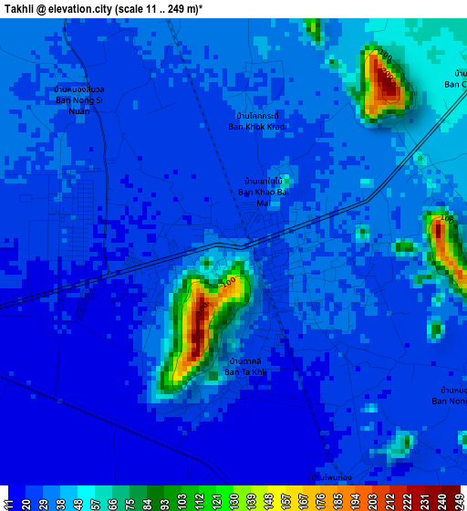
Below is the Elevation map of Takhli, which displays elevation range with different colors. Scale of the first map is from 11 to 249 m (36 to 817 ft) with average elevation of 34.1 meters (=112 ft) [note 1]
These maps also provides idea of topography and contour of this city, they are displayed at different zoom levels. More info about maps, scale and edge coordinates you can find below images.
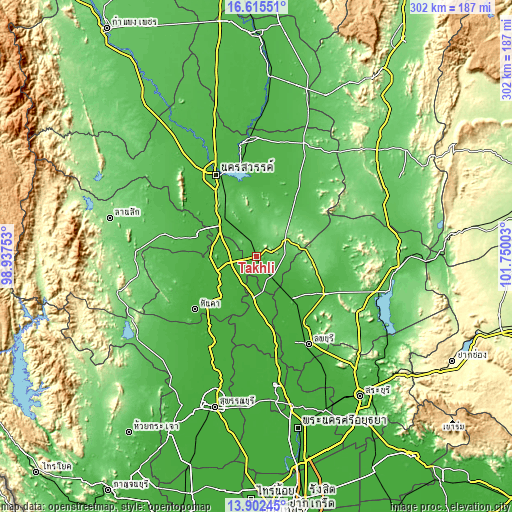
| \ | Map #1 | Topo.Map |
| Scale [m] | 11..249 m | × |
| Scale [ft] | 36..817 ft | × |
| Average | 34.1 m = 112 ft | × |
| Width | 9.43 km = 5.9 mi | 301.7 km = 187.5 mi |
| Height | 9.43 km = 5.9 mi | 301.7 km = 187.5 mi |
| ↑Max Latitude | 15.305751° | 16.61551° |
| Latitude at center | 15.26336° | 15.26336° |
| ↓Min Latitude | 15.220961° | 13.90245° |
| ← Min Longitude | 100.299835° | 98.93753° |
| Longitude center | 100.34378° | 100.34378° |
| →Max Longitude | 100.387725° | 101.75003° |
Nearby cities:
Cities around Takhli sort by population:
• Uthai Thani elevation 28 m
36.6 km,  290°
290°
• Chai Nat 26 m
25.1 km,  250°
250°
• Bang Racham 14 m
41.4 km,  183°
183°
• Phayuha Khiri 27 m
30.9 km,  313°
313°
• Nong Muang 119 m
33.5 km,  93°
93°
• Wat Sing 24 m
32.5 km,  269°
269°
• Ban Mi 16 m
32 km,  139°
139°
• Sankhaburi 22 m
31 km,  219°
219°
• Manorom 28 m
28.5 km,  280°
280°
• In Buri 19 m
28.5 km, 183°
• Tak Fa 91 m
18.8 km,  59°
59°
• Sapphaya 17 m
17 km, 219°
Multilingual:
 En español:
Takhli elevación 34 m.
 En France:
Takhli élévation 34 m.


Sources and notes:
- [note 1] Map square and city borders are not equal. Map elevation data is calculated only from area inside that square.
- [src 1] Elevation data from geonames database provided with same terms of usage.
- [src 2] The elevation map of Takhli is generated using elevation data from NASA's 3 arcsec (90m) resolution SRTM data.
- [src 3] Base (background) map © OpenStreetMap contributors tiles are generated by Geofabrik and OpenTopoMap.
Copyright & License:
This Takhli Elevation Map is licensed under CC BY-SA. You may reuse any part from this page, if you give a proper credit by linking to this URL:
 More info on terms of use page.