Chai Nat elevation
Chai Nat, Thailand elevation is 26 meters and Chai Nat elevation in feet is 85 ft above sea level [src 1]. Chai Nat is a seat of a first-order administrative division (feature code) with elevation that is 99 meters (325 ft) smaller than average city elevation in Thailand.
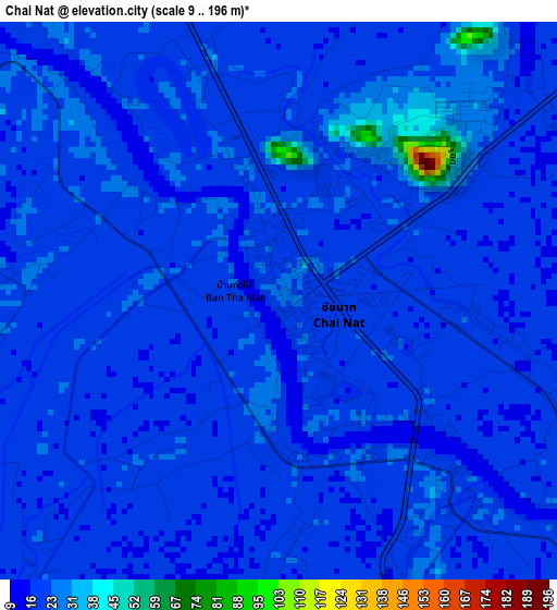
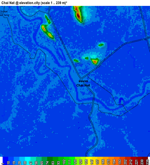
Below is the Elevation map of Chai Nat, which displays elevation range with different colors. Scale of the first map is from 9 to 196 m (30 to 643 ft) with average elevation of 21 meters (=69 ft) [note 1]
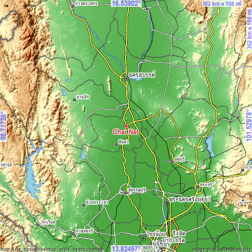
These maps also provides idea of topography and contour of this city, they are displayed at different zoom levels. More info about maps, scale and edge coordinates you can find below images.
| \ | Map #1 | Map #2 | Topo.Map |
| Scale [m] | 9..196 m | 1..239 m | × |
| Scale [ft] | 30..643 ft | 3..784 ft | × |
| Average | 21 m = 69 ft | 20 m = 66 ft | × |
| Width | 9.43 km = 5.9 mi | 18.86 km = 11.7 mi | 301.8 km = 187.5 mi |
| Height | 9.43 km = 5.9 mi | 18.86 km = 11.7 mi | 301.8 km = 187.5 mi |
| ↑Max Latitude | 15.228766° | 15.271164° | 16.53902° |
| Latitude at center | 15.18636° | 15.18636° | 15.18636° |
| ↓Min Latitude | 15.143945° | 15.101522° | 13.82497° |
| ← Min Longitude | 100.079585° | 100.035639° | 98.71728° |
| Longitude center | 100.12353° | 100.12353° | 100.12353° |
| →Max Longitude | 100.167475° | 100.211421° | 101.52978° |
Nearby cities:
Cities around Chai Nat sort by population:
• Uthai Thani elevation 28 m
23.9 km,  333°
333°
• Phayuha Khiri 27 m
29.9 km,  2°
2°
• Noen Kham 29 m
32.9 km,  217°
217°
• In Buri 19 m
29.5 km,  132°
132°
• Nong Mamong 47 m
29.3 km,  289°
289°
• Nong Kha Yang 41 m
28.7 km,  313°
313°
• Hankha 20 m
25.6 km,  207°
207°
• Takhli 34 m
25.1 km,  70°
70°
• Sankhaburi 22 m
16 km,  165°
165°
• Manorom 28 m
14.4 km,  342°
342°
• Sapphaya 17 m
13.5 km,  109°
109°
• Wat Sing 24 m
12.1 km, 312°
Multilingual:
 En español:
Chai Nat elevación 26 m.
 En France:
Chainat élévation 26 m.


Sources and notes:
- [note 1] Map square and city borders are not equal. Map elevation data is calculated only from area inside that square.
- [src 1] Elevation data from geonames database provided with same terms of usage.
- [src 2] The elevation map of Chai Nat is generated using elevation data from NASA's 3 arcsec (90m) resolution SRTM data.
- [src 3] Base (background) map © OpenStreetMap contributors tiles are generated by Geofabrik and OpenTopoMap.
Copyright & License:
This Chai Nat Elevation Map is licensed under CC BY-SA. You may reuse any part from this page, if you give a proper credit by linking to this URL:
 More info on terms of use page.