Nong Wua So elevation
Nong Wua So (Changwat Udon Thani), Thailand elevation is 239 meters and Nong Wua So elevation in feet is 784 ft above sea level [src 1]. Nong Wua So is a seat of a second-order administrative division (feature code) with elevation that is 114 meters (374 ft) bigger than average city elevation in Thailand.
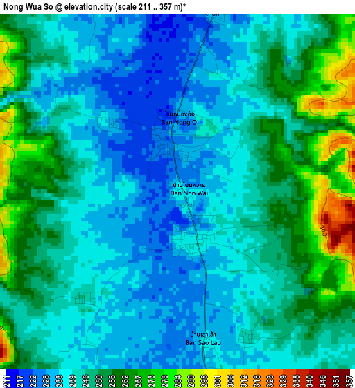
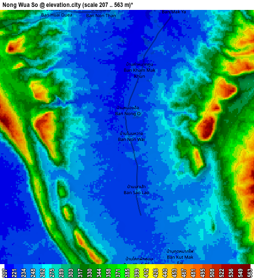
Below is the Elevation map of Nong Wua So, which displays elevation range with different colors. Scale of the first map is from 211 to 357 m (692 to 1171 ft) with average elevation of 245.2 meters (=804 ft) [note 1]
These maps also provides idea of topography and contour of this city, they are displayed at different zoom levels. More info about maps, scale and edge coordinates you can find below images.
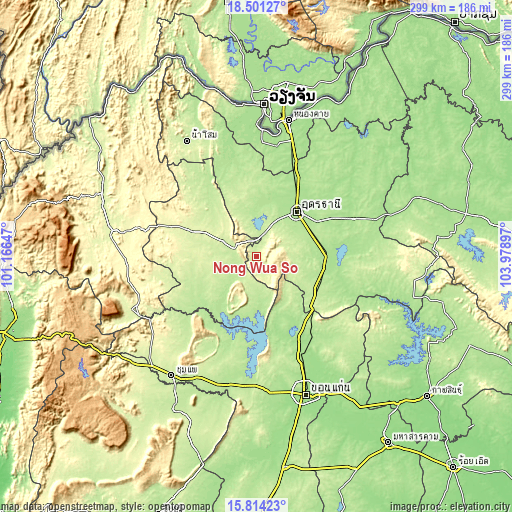
| \ | Map #1 | Map #2 | Topo.Map |
| Scale [m] | 211..357 m | 207..563 m | × |
| Scale [ft] | 692..1171 ft | 679..1847 ft | × |
| Average | 245.2 m = 804 ft | 283.7 m = 931 ft | × |
| Width | 9.34 km = 5.8 mi | 18.67 km = 11.6 mi | 298.8 km = 185.7 mi |
| Height | 9.34 km = 5.8 mi | 18.67 km = 11.6 mi | 298.8 km = 185.7 mi |
| ↑Max Latitude | 17.204594° | 17.246568° | 18.50127° |
| Latitude at center | 17.16261° | 17.16261° | 17.16261° |
| ↓Min Latitude | 17.120617° | 17.078614° | 15.81423° |
| ← Min Longitude | 102.528775° | 102.484829° | 101.16647° |
| Longitude center | 102.57272° | 102.57272° | 102.57272° |
| →Max Longitude | 102.616665° | 102.660611° | 103.97897° |
Nearby cities:
Cities around Nong Wua So sort by population:
• Udon Thani elevation 177 m
36.1 km,  38°
38°
• Nong Bua Lamphu 217 m
14.8 km,  288°
288°
• Na Klang 253 m
43.8 km, 291°
• Ban Phan Don 180 m
42.5 km,  92°
92°
• Kut Chap 197 m
29.3 km,  358°
358°
• Si Bun Rueang 211 m
38.3 km,  235°
235°
• Non Sang 186 m
32.7 km,  181°
181°
• Ban Na Muang 177 m
47.1 km,  79°
79°
• Khuean Ubonrat 198 m
46 km,  172°
172°
• Ubonratana 198 m
46 km, 172°
• Non Sa-at 220 m
39.8 km,  120°
120°
• Nong Saeng 227 m
22.1 km, 88°
Multilingual:
 En español:
Nong Wua So elevación 239 m.
 En France:
Nong Wua So élévation 239 m.
 Auf Deutsch:
Nong Wua So höhe über dem Meeresspiegel ist 239 m.

Sources and notes:
- [note 1] Map square and city borders are not equal. Map elevation data is calculated only from area inside that square.
- [src 1] Elevation data from geonames database provided with same terms of usage.
- [src 2] The elevation map of Nong Wua So is generated using elevation data from NASA's 3 arcsec (90m) resolution SRTM data.
- [src 3] Base (background) map © OpenStreetMap contributors tiles are generated by Geofabrik and OpenTopoMap.
Copyright & License:
This Nong Wua So Elevation Map is licensed under CC BY-SA. You may reuse any part from this page, if you give a proper credit by linking to this URL:
 More info on terms of use page.