Non Sang elevation
Non Sang (Changwat Nong Bua Lamphu), Thailand elevation is 186 meters and Non Sang elevation in feet is 610 ft above sea level [src 1]. Non Sang is a seat of a second-order administrative division (feature code) with elevation that is 61 meters (200 ft) bigger than average city elevation in Thailand.
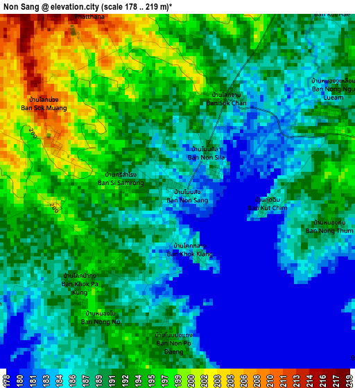
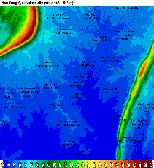
Below is the Elevation map of Non Sang, which displays elevation range with different colors. Scale of the first map is from 178 to 219 m (584 to 719 ft) with average elevation of 190.1 meters (=624 ft) [note 1]
These maps also provides idea of topography and contour of this city, they are displayed at different zoom levels. More info about maps, scale and edge coordinates you can find below images.
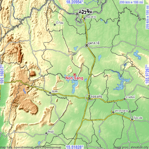
| \ | Map #1 | Map #2 | Topo.Map |
| Scale [m] | 178..219 m | 168..513 m | × |
| Scale [ft] | 584..719 ft | 551..1683 ft | × |
| Average | 190.1 m = 624 ft | 209.6 m = 688 ft | × |
| Width | 9.35 km = 5.8 mi | 18.7 km = 11.6 mi | 299.2 km = 185.9 mi |
| Height | 9.35 km = 5.8 mi | 18.7 km = 11.6 mi | 299.3 km = 186 mi |
| ↑Max Latitude | 16.91075° | 16.95279° | 18.20954° |
| Latitude at center | 16.8687° | 16.8687° | 16.8687° |
| ↓Min Latitude | 16.826641° | 16.784572° | 15.51828° |
| ← Min Longitude | 102.522475° | 102.478529° | 101.16017° |
| Longitude center | 102.56642° | 102.56642° | 102.56642° |
| →Max Longitude | 102.610365° | 102.654311° | 103.97267° |
Nearby cities:
Cities around Non Sang sort by population:
• Nong Bua Lamphu elevation 217 m
39.6 km,  340°
340°
• Si Bun Rueang 211 m
32.8 km,  289°
289°
• Nong Wua So 239 m
32.7 km,  1°
1°
• Si Chomphu 209 m
41.4 km,  259°
259°
• Nong Saeng 227 m
40.3 km,  34°
34°
• Non Sa-at 220 m
36.9 km,  70°
70°
• Wiang Kao 219 m
36.4 km,  235°
235°
• Nam Phong 172 m
35.9 km,  121°
121°
• Phu Wiang 205 m
31.5 km,  220°
220°
• Nong Na Kham 193 m
25.5 km,  253°
253°
• Khuean Ubonrat 198 m
14.7 km,  151°
151°
• Ubonratana 198 m
14.7 km, 151°
Multilingual:
 En español:
Non Sang elevación 186 m.
 En France:
Non Sang élévation 186 m.
 Auf Deutsch:
Non Sang höhe über dem Meeresspiegel ist 186 m.

Sources and notes:
- [note 1] Map square and city borders are not equal. Map elevation data is calculated only from area inside that square.
- [src 1] Elevation data from geonames database provided with same terms of usage.
- [src 2] The elevation map of Non Sang is generated using elevation data from NASA's 3 arcsec (90m) resolution SRTM data.
- [src 3] Base (background) map © OpenStreetMap contributors tiles are generated by Geofabrik and OpenTopoMap.
Copyright & License:
This Non Sang Elevation Map is licensed under CC BY-SA. You may reuse any part from this page, if you give a proper credit by linking to this URL:
 More info on terms of use page.