Bokoro elevation
Bokoro (Hadjer-Lamis), Chad elevation is 300 meters and Bokoro elevation in feet is 984 ft above sea level [src 1]. Bokoro is a populated place (feature code) with elevation that is 140 meters (459 ft) smaller than average city elevation in Chad.
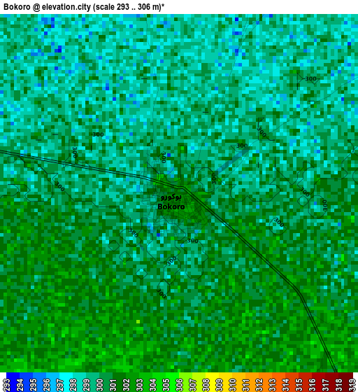
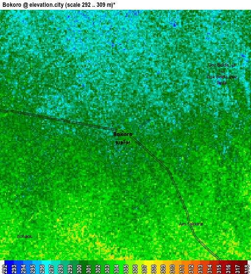
Below is the Elevation map of Bokoro, which displays elevation range with different colors. Scale of the first map is from 293 to 306 m (961 to 1004 ft) with average elevation of 299.9 meters (=984 ft) [note 1]
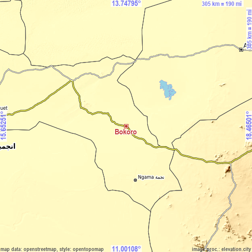
These maps also provides idea of topography and contour of this city, they are displayed at different zoom levels. More info about maps, scale and edge coordinates you can find below images.
| \ | Map #1 | Map #2 | Topo.Map |
| Scale [m] | 293..306 m | 292..309 m | × |
| Scale [ft] | 961..1004 ft | 958..1014 ft | × |
| Average | 299.9 m = 984 ft | 300.3 m = 985 ft | × |
| Width | 9.55 km = 5.9 mi | 19.09 km = 11.9 mi | 305.4 km = 189.8 mi |
| Height | 9.55 km = 5.9 mi | 19.09 km = 11.9 mi | 305.4 km = 189.8 mi |
| ↑Max Latitude | 12.42105° | 12.463963° | 13.74795° |
| Latitude at center | 12.37813° | 12.37813° | 12.37813° |
| ↓Min Latitude | 12.335203° | 12.292268° | 11.00108° |
| ← Min Longitude | 17.014815° | 16.970869° | 15.65251° |
| Longitude center | 17.05876° | 17.05876° | 17.05876° |
| →Max Longitude | 17.102705° | 17.146651° | 18.46501° |
Nearby cities:
Cities around Bokoro sort by population:
• N'Djamena elevation 299 m
221 km,  262°
262°
• Mongo 424 m
178.9 km,  96°
96°
• Ati 336 m
166.8 km,  56°
56°
• Bitkine 468 m
133.1 km,  109°
109°
• Massaguet 292 m
176.5 km,  273°
273°
• Dourbali 305 m
144.3 km,  243°
243°
• Massakory 287 m
159.7 km,  295°
295°
• Moussoro 304 m
153.4 km,  336°
336°
• Bousso 337 m
213.9 km,  190°
190°
• Ngama 326 m
67.2 km,  169°
169°
• Melfi 399 m
174.9 km,  146°
146°
• Massenya 327 m
145.2 km,  221°
221°
Multilingual:
 En español:
Bokoro elevación 300 m.
 En France:
Bokoro élévation 300 m.


Sources and notes:
- [note 1] Map square and city borders are not equal. Map elevation data is calculated only from area inside that square.
- [src 1] Elevation data from geonames database provided with same terms of usage.
- [src 2] The elevation map of Bokoro is generated using elevation data from NASA's 3 arcsec (90m) resolution SRTM data.
- [src 3] Base (background) map © OpenStreetMap contributors tiles are generated by Geofabrik and OpenTopoMap.
Copyright & License:
This Bokoro Elevation Map is licensed under CC BY-SA. You may reuse any part from this page, if you give a proper credit by linking to this URL:
 More info on terms of use page.