Armenia elevation
Armenia (Sonsonate), El Salvador elevation is 559 meters and Armenia elevation in feet is 1834 ft above sea level [src 1]. Armenia is a populated place (feature code) with elevation that is 88 meters (289 ft) bigger than average city elevation in El Salvador.
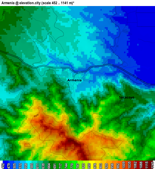
Below is the Elevation map of Armenia, which displays elevation range with different colors. Scale of the first map is from 452 to 1141 m (1483 to 3743 ft) with average elevation of 662.6 meters (=2174 ft) [note 1]
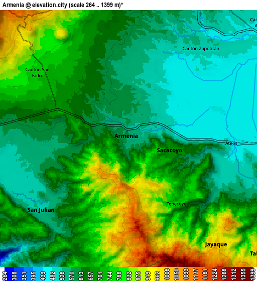
These maps also provides idea of topography and contour of this city, they are displayed at different zoom levels. More info about maps, scale and edge coordinates you can find below images.
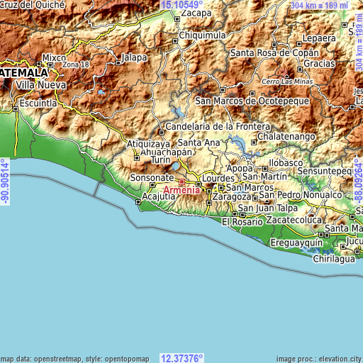
| \ | Map #1 | Map #2 | Topo.Map |
| Scale [m] | 452..1141 m | 264..1399 m | × |
| Scale [ft] | 1483..3743 ft | 866..4590 ft | × |
| Average | 662.6 m = 2174 ft | 674.5 m = 2213 ft | × |
| Width | 9.49 km = 5.9 mi | 18.99 km = 11.8 mi | 303.7 km = 188.7 mi |
| Height | 9.49 km = 5.9 mi | 18.99 km = 11.8 mi | 303.8 km = 188.8 mi |
| ↑Max Latitude | 13.786293° | 13.828969° | 15.10549° |
| Latitude at center | 13.74361° | 13.74361° | 13.74361° |
| ↓Min Latitude | 13.700919° | 13.65822° | 12.37376° |
| ← Min Longitude | -89.542835° | -89.586781° | -90.90514° |
| Longitude center | -89.49889° | -89.49889° | -89.49889° |
| →Max Longitude | -89.454945° | -89.410999° | -88.09264° |
Nearby cities:
Cities around Armenia sort by population:
• Santa Tecla elevation 935 m
24.8 km,  107°
107°
• Sonsonate 235 m
24.5 km,  263°
263°
• Quezaltepeque 443 m
26.3 km,  68°
68°
• Izalco 422 m
18.8 km,  270°
270°
• Sonzacate 275 m
23.3 km, 267°
• Ciudad Arce 554 m
12.1 km,  27°
27°
• San Antonio del Monte 224 m
26 km, 263°
• El Congo 847 m
18.4 km,  1°
1°
• Nahuizalco 544 m
26 km,  278°
278°
• San Juan Opico 518 m
21 km,  45°
45°
• Nuevo Cuscatlán 906 m
27.4 km, 112°
• Coatepeque 756 m
20.6 km,  358°
358°
Multilingual:
 En español:
Armenia elevación 559 m.
 En France:
Armenia élévation 559 m.


Sources and notes:
- [note 1] Map square and city borders are not equal. Map elevation data is calculated only from area inside that square.
- [src 1] Elevation data from geonames database provided with same terms of usage.
- [src 2] The elevation map of Armenia is generated using elevation data from NASA's 3 arcsec (90m) resolution SRTM data.
- [src 3] Base (background) map © OpenStreetMap contributors tiles are generated by Geofabrik and OpenTopoMap.
Copyright & License:
This Armenia Elevation Map is licensed under CC BY-SA. You may reuse any part from this page, if you give a proper credit by linking to this URL:
 More info on terms of use page.