Coatepeque elevation
Coatepeque (Santa Ana), El Salvador elevation is 756 meters and Coatepeque elevation in feet is 2480 ft above sea level [src 1]. Coatepeque is a populated place (feature code) with elevation that is 285 meters (935 ft) bigger than average city elevation in El Salvador.
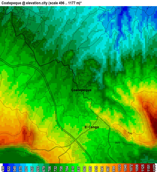
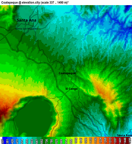
Below is the Elevation map of Coatepeque, which displays elevation range with different colors. Scale of the first map is from 496 to 1177 m (1627 to 3862 ft) with average elevation of 772.6 meters (=2535 ft) [note 1]
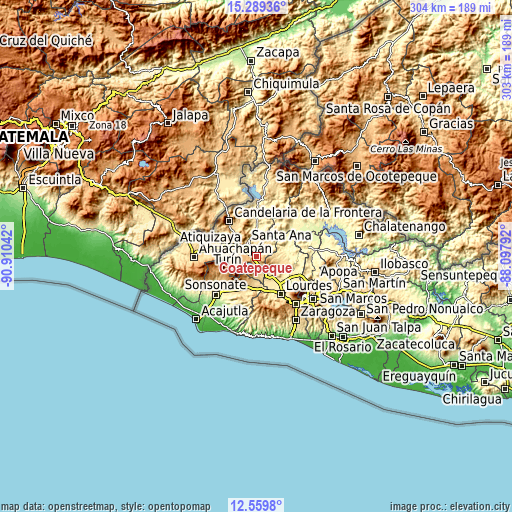
These maps also provides idea of topography and contour of this city, they are displayed at different zoom levels. More info about maps, scale and edge coordinates you can find below images.
| \ | Map #1 | Map #2 | Topo.Map |
| Scale [m] | 496..1177 m | 337..1490 m | × |
| Scale [ft] | 1627..3862 ft | 1106..4888 ft | × |
| Average | 772.6 m = 2535 ft | 739.3 m = 2426 ft | × |
| Width | 9.49 km = 5.9 mi | 18.97 km = 11.8 mi | 303.5 km = 188.6 mi |
| Height | 9.49 km = 5.9 mi | 18.97 km = 11.8 mi | 303.5 km = 188.6 mi |
| ↑Max Latitude | 13.971259° | 14.013901° | 15.28936° |
| Latitude at center | 13.92861° | 13.92861° | 13.92861° |
| ↓Min Latitude | 13.885953° | 13.843288° | 12.5598° |
| ← Min Longitude | -89.548115° | -89.592061° | -90.91042° |
| Longitude center | -89.50417° | -89.50417° | -89.50417° |
| →Max Longitude | -89.460225° | -89.416279° | -88.09792° |
Nearby cities:
Cities around Coatepeque sort by population:
• Santa Ana elevation 649 m
9.4 km,  320°
320°
• Chalchuapa 710 m
20.2 km,  288°
288°
• Quezaltepeque 443 m
27.3 km,  113°
113°
• Izalco 422 m
27.4 km,  221°
221°
• Armenia 559 m
20.6 km,  178°
178°
• Ciudad Arce 554 m
11.6 km,  147°
147°
• Atiquizaya 615 m
27.3 km,  281°
281°
• El Congo 847 m
2.4 km,  157°
157°
• San Juan Opico 518 m
16.6 km, 110°
• Candelaria de La Frontera 712 m
26.2 km, 323°
• San Pablo Tacachico 317 m
18.5 km,  73°
73°
• Texistepeque 416 m
22.8 km,  1°
1°
Multilingual:
 En español:
Coatepeque elevación 756 m.
 En France:
Coatepeque élévation 756 m.
 Auf Deutsch:
Coatepeque höhe über dem Meeresspiegel ist 756 m.

Sources and notes:
- [note 1] Map square and city borders are not equal. Map elevation data is calculated only from area inside that square.
- [src 1] Elevation data from geonames database provided with same terms of usage.
- [src 2] The elevation map of Coatepeque is generated using elevation data from NASA's 3 arcsec (90m) resolution SRTM data.
- [src 3] Base (background) map © OpenStreetMap contributors tiles are generated by Geofabrik and OpenTopoMap.
Copyright & License:
This Coatepeque Elevation Map is licensed under CC BY-SA. You may reuse any part from this page, if you give a proper credit by linking to this URL:
 More info on terms of use page.