El Tránsito elevation
El Tránsito (San Miguel), El Salvador elevation is 119 meters and El Tránsito elevation in feet is 390 ft above sea level [src 1]. El Tránsito is a populated place (feature code) with elevation that is 352 meters (1155 ft) smaller than average city elevation in El Salvador.
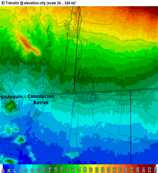
Below is the Elevation map of El Tránsito, which displays elevation range with different colors. Scale of the first map is from 24 to 324 m (79 to 1063 ft) with average elevation of 120.9 meters (=397 ft) [note 1]
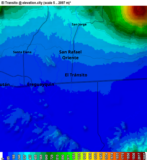
These maps also provides idea of topography and contour of this city, they are displayed at different zoom levels. More info about maps, scale and edge coordinates you can find below images.
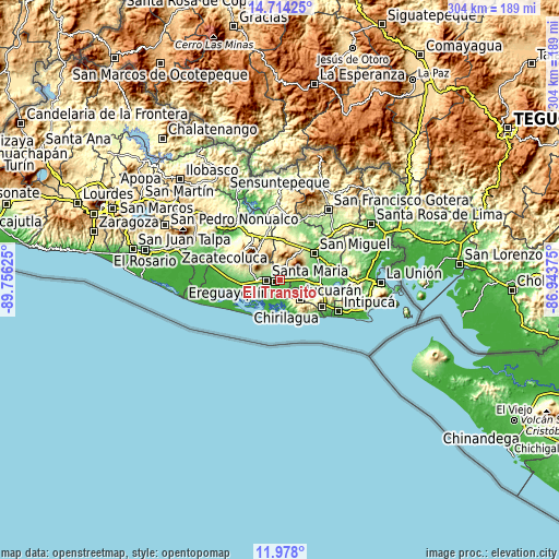
| \ | Map #1 | Map #2 | Topo.Map |
| Scale [m] | 24..324 m | 5..2097 m | × |
| Scale [ft] | 79..1063 ft | 16..6880 ft | × |
| Average | 120.9 m = 397 ft | 208.2 m = 683 ft | × |
| Width | 9.51 km = 5.9 mi | 19.02 km = 11.8 mi | 304.2 km = 189 mi |
| Height | 9.51 km = 5.9 mi | 19.02 km = 11.8 mi | 304.3 km = 189.1 mi |
| ↑Max Latitude | 13.392754° | 13.4355° | 14.71425° |
| Latitude at center | 13.35° | 13.35° | 13.35° |
| ↓Min Latitude | 13.307238° | 13.264469° | 11.978° |
| ← Min Longitude | -88.393945° | -88.437891° | -89.75625° |
| Longitude center | -88.35° | -88.35° | -88.35° |
| →Max Longitude | -88.306055° | -88.262109° | -86.94375° |
Nearby cities:
Cities around El Tránsito sort by population:
• Usulután elevation 105 m
10.8 km,  270°
270°
• San Rafael Oriente 212 m
3.7 km,  0°
0°
• Puerto El Triunfo 15 m
22.9 km,  251°
251°
• Santiago de María 896 m
19.5 km,  319°
319°
• Jucuapa 476 m
18.9 km,  348°
348°
• Chinameca 718 m
16.7 km, 0°
• Santa Elena 180 m
8.1 km,  297°
297°
• Nueva Guadalupe 495 m
20.4 km, 0°
• Ozatlán 237 m
16.6 km,  282°
282°
• Concepción Batres 108 m
1.8 km, 270°
• Lolotique 527 m
22.2 km, 0°
• Jucuarán 675 m
15.4 km,  134°
134°
Multilingual:
 En español:
El Tránsito elevación 119 m.
 En France:
El Tránsito élévation 119 m.
 Auf Deutsch:
El Tránsito höhe über dem Meeresspiegel ist 119 m.

Sources and notes:
- [note 1] Map square and city borders are not equal. Map elevation data is calculated only from area inside that square.
- [src 1] Elevation data from geonames database provided with same terms of usage.
- [src 2] The elevation map of El Tránsito is generated using elevation data from NASA's 3 arcsec (90m) resolution SRTM data.
- [src 3] Base (background) map © OpenStreetMap contributors tiles are generated by Geofabrik and OpenTopoMap.
Copyright & License:
This El Tránsito Elevation Map is licensed under CC BY-SA. You may reuse any part from this page, if you give a proper credit by linking to this URL:
 More info on terms of use page.