Sesori elevation
Sesori (San Miguel), El Salvador elevation is 184 meters and Sesori elevation in feet is 604 ft above sea level [src 1]. Sesori is a populated place (feature code) with elevation that is 287 meters (942 ft) smaller than average city elevation in El Salvador.
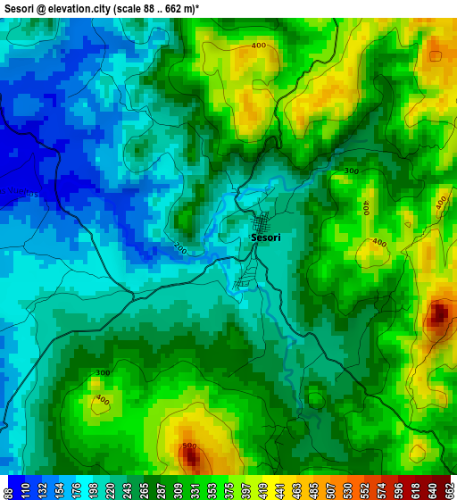
Below is the Elevation map of Sesori, which displays elevation range with different colors. Scale of the first map is from 88 to 662 m (289 to 2172 ft) with average elevation of 279.1 meters (=916 ft) [note 1]
These maps also provides idea of topography and contour of this city, they are displayed at different zoom levels. More info about maps, scale and edge coordinates you can find below images.
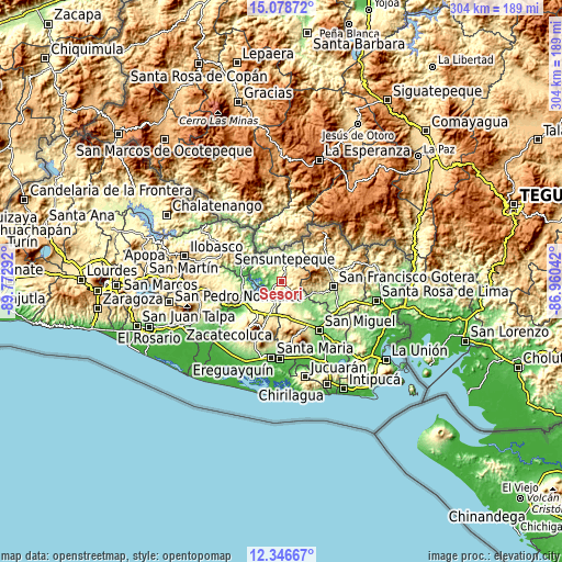
| \ | Map #1 | Topo.Map |
| Scale [m] | 88..662 m | × |
| Scale [ft] | 289..2172 ft | × |
| Average | 279.1 m = 916 ft | × |
| Width | 9.49 km = 5.9 mi | 303.8 km = 188.8 mi |
| Height | 9.49 km = 5.9 mi | 303.8 km = 188.8 mi |
| ↑Max Latitude | 13.759358° | 15.07872° |
| Latitude at center | 13.71667° | 13.71667° |
| ↓Min Latitude | 13.673974° | 12.34667° |
| ← Min Longitude | -88.410615° | -89.77292° |
| Longitude center | -88.36667° | -88.36667° |
| →Max Longitude | -88.322725° | -86.96042° |
Nearby cities:
Cities around Sesori sort by population:
• San Francisco elevation 270 m
28.9 km,  93°
93°
• Santiago de María 896 m
28.1 km,  202°
202°
• Berlín 975 m
30.1 km,  216°
216°
• Jucuapa 476 m
22.3 km,  184°
184°
• Chinameca 718 m
24.2 km, 175°
• Ciudad Barrios 847 m
12.1 km,  62°
62°
• Nueva Guadalupe 495 m
20.5 km,  174°
174°
• Guatajiagua 288 m
18.8 km,  107°
107°
• Chapeltique 186 m
14.2 km,  130°
130°
• Lolotique 527 m
18.6 km, 174°
• Cacaopera 636 m
31.1 km,  79°
79°
• Moncagua 231 m
24 km,  148°
148°
Multilingual:
 En español:
Sesori elevación 184 m.
 En France:
Sesori élévation 184 m.


Sources and notes:
- [note 1] Map square and city borders are not equal. Map elevation data is calculated only from area inside that square.
- [src 1] Elevation data from geonames database provided with same terms of usage.
- [src 2] The elevation map of Sesori is generated using elevation data from NASA's 3 arcsec (90m) resolution SRTM data.
- [src 3] Base (background) map © OpenStreetMap contributors tiles are generated by Geofabrik and OpenTopoMap.
Copyright & License:
This Sesori Elevation Map is licensed under CC BY-SA. You may reuse any part from this page, if you give a proper credit by linking to this URL:
 More info on terms of use page.