Yei elevation
Yei (Yei River), South Sudan elevation is 836 meters and Yei elevation in feet is 2743 ft above sea level [src 1]. Yei is a seat of a first-order administrative division (feature code) with elevation that is 347 meters (1138 ft) bigger than average city elevation in South Sudan.
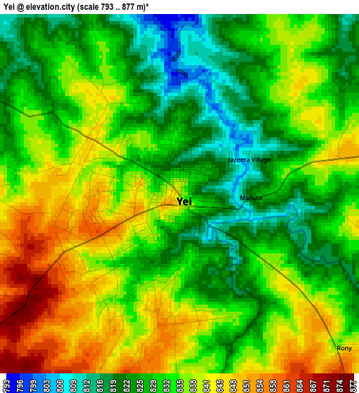
Below is the Elevation map of Yei, which displays elevation range with different colors. Scale of the first map is from 793 to 877 m (2602 to 2877 ft) with average elevation of 833.3 meters (=2734 ft) [note 1]
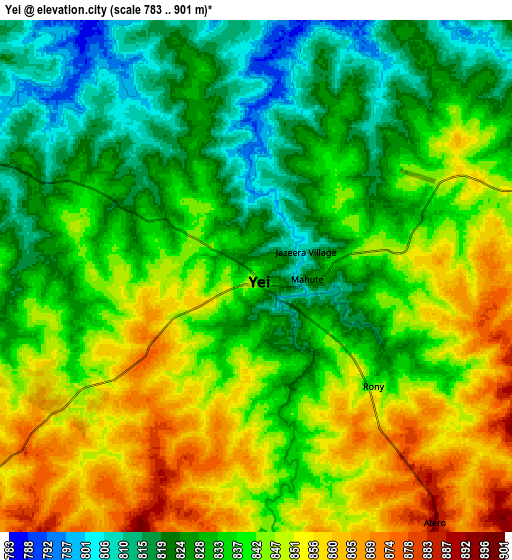
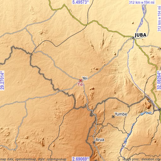
These maps also provides idea of topography and contour of this city, they are displayed at different zoom levels. More info about maps, scale and edge coordinates you can find below images.
| \ | Map #1 | Map #2 | Topo.Map |
| Scale [m] | 793..877 m | 783..901 m | × |
| Scale [ft] | 2602..2877 ft | 2569..2956 ft | × |
| Average | 833.3 m = 2734 ft | 837.8 m = 2749 ft | × |
| Width | 9.75 km = 6.1 mi | 19.5 km = 12.1 mi | 311.9 km = 193.8 mi |
| Height | 9.75 km = 6.1 mi | 19.5 km = 12.1 mi | 311.9 km = 193.8 mi |
| ↑Max Latitude | 4.138272° | 4.182101° | 5.49573° |
| Latitude at center | 4.09444° | 4.09444° | 4.09444° |
| ↓Min Latitude | 4.050606° | 4.006769° | 2.69069° |
| ← Min Longitude | 30.632445° | 30.588499° | 29.27014° |
| Longitude center | 30.67639° | 30.67639° | 30.67639° |
| →Max Longitude | 30.720335° | 30.764281° | 32.08264° |
Nearby cities:
Cities around Yei sort by population:
• Juba elevation 518 m
131.1 km,  50°
50°
• Pajok 823 m
201.9 km,  97°
97°
• Yambio 655 m
258.5 km,  281°
281°
• Rumbek 428 m
321.1 km,  339°
339°
• Bor 429 m
254.6 km,  22°
22°
• Torit 617 m
213 km,  80°
80°
• Maridi 727 m
162 km,  304°
304°
• Kapoeta 668 m
331.8 km, 76°
• Cueibet 423 m
362.4 km,  334°
334°
• Yirol 444 m
274 km,  355°
355°
• Terekeka 445 m
191.5 km,  38°
38°
• Mundri 560 m
144.7 km, 344°
Multilingual:
 En español:
Yei elevación 836 m.
 En France:
Yei élévation 836 m.


Sources and notes:
- [note 1] Map square and city borders are not equal. Map elevation data is calculated only from area inside that square.
- [src 1] Elevation data from geonames database provided with same terms of usage.
- [src 2] The elevation map of Yei is generated using elevation data from NASA's 3 arcsec (90m) resolution SRTM data.
- [src 3] Base (background) map © OpenStreetMap contributors tiles are generated by Geofabrik and OpenTopoMap.
Copyright & License:
This Yei Elevation Map is licensed under CC BY-SA. You may reuse any part from this page, if you give a proper credit by linking to this URL:
 More info on terms of use page.