Yambio elevation
Yambio (Gbudwe), South Sudan elevation is 655 meters and Yambio elevation in feet is 2149 ft above sea level [src 1]. Yambio is a seat of a first-order administrative division (feature code) with elevation that is 166 meters (545 ft) bigger than average city elevation in South Sudan.
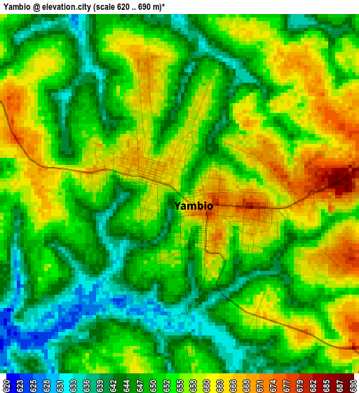
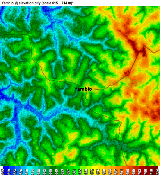
Below is the Elevation map of Yambio, which displays elevation range with different colors. Scale of the first map is from 620 to 690 m (2034 to 2264 ft) with average elevation of 652.5 meters (=2141 ft) [note 1]
These maps also provides idea of topography and contour of this city, they are displayed at different zoom levels. More info about maps, scale and edge coordinates you can find below images.
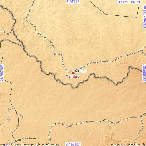
| \ | Map #1 | Map #2 | Topo.Map |
| Scale [m] | 620..690 m | 615..714 m | × |
| Scale [ft] | 2034..2264 ft | 2018..2343 ft | × |
| Average | 652.5 m = 2141 ft | 655.4 m = 2150 ft | × |
| Width | 9.74 km = 6.1 mi | 19.48 km = 12.1 mi | 311.7 km = 193.7 mi |
| Height | 9.74 km = 6.1 mi | 19.48 km = 12.1 mi | 311.7 km = 193.7 mi |
| ↑Max Latitude | 4.614634° | 4.658436° | 5.9711° |
| Latitude at center | 4.57083° | 4.57083° | 4.57083° |
| ↓Min Latitude | 4.527023° | 4.483214° | 3.16782° |
| ← Min Longitude | 28.350225° | 28.306279° | 26.98792° |
| Longitude center | 28.39417° | 28.39417° | 28.39417° |
| →Max Longitude | 28.438115° | 28.482061° | 29.80042° |
Nearby cities:
Cities around Yambio sort by population:
• Juba elevation 518 m
354.7 km,  84°
84°
• Wau 440 m
350.9 km,  352°
352°
• Yei 836 m
258.5 km,  101°
101°
• Rumbek 428 m
286.2 km,  29°
29°
• Bor 429 m
394.8 km,  62°
62°
• Tonj 444 m
302.2 km,  5°
5°
• Maridi 727 m
125.2 km,  72°
72°
• Tambura 630 m
153.8 km,  318°
318°
• Terekeka 445 m
384.3 km, 75°
• Yirol 444 m
320.6 km,  46°
46°
• Cueibet 423 m
288.9 km,  19°
19°
• Mundri 560 m
230.6 km, 68°
Multilingual:
 En español:
Yambio elevación 655 m.
 En France:
Yambio élévation 655 m.


Sources and notes:
- [note 1] Map square and city borders are not equal. Map elevation data is calculated only from area inside that square.
- [src 1] Elevation data from geonames database provided with same terms of usage.
- [src 2] The elevation map of Yambio is generated using elevation data from NASA's 3 arcsec (90m) resolution SRTM data.
- [src 3] Base (background) map © OpenStreetMap contributors tiles are generated by Geofabrik and OpenTopoMap.
Copyright & License:
This Yambio Elevation Map is licensed under CC BY-SA. You may reuse any part from this page, if you give a proper credit by linking to this URL:
 More info on terms of use page.