Kamakwie elevation
Kamakwie (Northern Province), Sierra Leone elevation is 116 meters and Kamakwie elevation in feet is 381 ft above sea level [src 1]. Kamakwie is a populated place (feature code) with elevation that is 41 meters (135 ft) smaller than average city elevation in Sierra Leone.
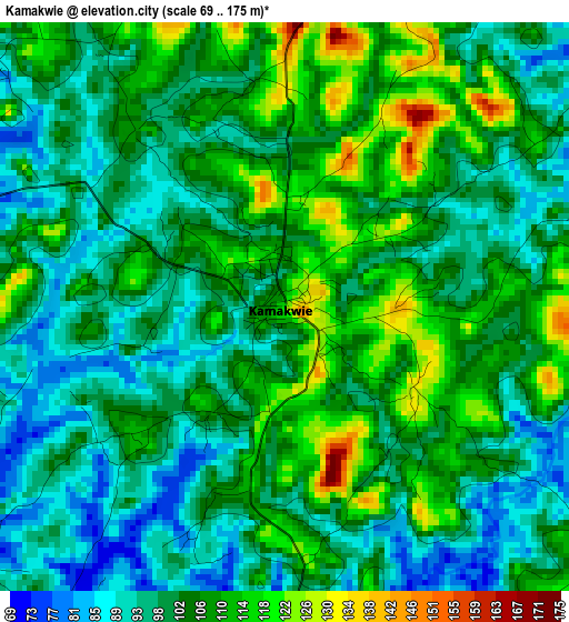
Below is the Elevation map of Kamakwie, which displays elevation range with different colors. Scale of the first map is from 69 to 175 m (226 to 574 ft) with average elevation of 102.5 meters (=336 ft) [note 1]
These maps also provides idea of topography and contour of this city, they are displayed at different zoom levels. More info about maps, scale and edge coordinates you can find below images.
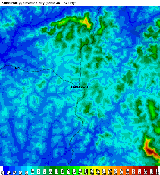
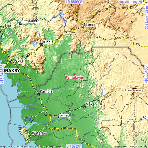
| \ | Map #1 | Map #2 | Topo.Map |
| Scale [m] | 69..175 m | 48..372 m | × |
| Scale [ft] | 226..574 ft | 157..1220 ft | × |
| Average | 102.5 m = 336 ft | 98.3 m = 323 ft | × |
| Width | 9.64 km = 6 mi | 19.28 km = 12 mi | 308.4 km = 191.6 mi |
| Height | 9.64 km = 6 mi | 19.28 km = 12 mi | 308.4 km = 191.6 mi |
| ↑Max Latitude | 9.54023° | 9.583565° | 10.88093° |
| Latitude at center | 9.49689° | 9.49689° | 9.49689° |
| ↓Min Latitude | 9.453544° | 9.410193° | 8.10724° |
| ← Min Longitude | -12.284555° | -12.328501° | -13.64686° |
| Longitude center | -12.24061° | -12.24061° | -12.24061° |
| →Max Longitude | -12.196665° | -12.152719° | -10.83436° |
Nearby cities:
Cities around Kamakwie sort by population:
• Makeni elevation 93 m
71.3 km,  162°
162°
• Lunsar 64 m
95.9 km,  199°
199°
• Kabala 433 m
76.1 km,  82°
82°
• Magburaka 99 m
91.8 km, 159°
• Binkolo 119 m
67 km,  154°
154°
• Rokupr 83 m
93.2 km,  189°
189°
• Kambia 32 m
85.1 km,  240°
240°
• Kukuna 47 m
47.8 km,  256°
256°
• Masingbi 109 m
85.6 km, 158°
• Loma 139 m
36.9 km,  37°
37°
• Mange 19 m
93 km,  226°
226°
• Bumbuna 127 m
74 km,  132°
132°
Multilingual:
 En español:
Kamakwie elevación 116 m.
 En France:
Kamakwie élévation 116 m.
 Auf Deutsch:
Kamakwie höhe über dem Meeresspiegel ist 116 m.

Sources and notes:
- [note 1] Map square and city borders are not equal. Map elevation data is calculated only from area inside that square.
- [src 1] Elevation data from geonames database provided with same terms of usage.
- [src 2] The elevation map of Kamakwie is generated using elevation data from NASA's 3 arcsec (90m) resolution SRTM data.
- [src 3] Base (background) map © OpenStreetMap contributors tiles are generated by Geofabrik and OpenTopoMap.
Copyright & License:
This Kamakwie Elevation Map is licensed under CC BY-SA. You may reuse any part from this page, if you give a proper credit by linking to this URL:
 More info on terms of use page.