Masingbi elevation
Masingbi (Northern Province), Sierra Leone elevation is 109 meters and Masingbi elevation in feet is 358 ft above sea level [src 1]. Masingbi is a populated place (feature code) with elevation that is 48 meters (157 ft) smaller than average city elevation in Sierra Leone.
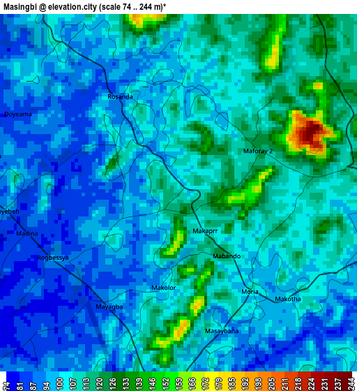
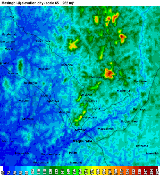
Below is the Elevation map of Masingbi, which displays elevation range with different colors. Scale of the first map is from 74 to 244 m (243 to 801 ft) with average elevation of 103.9 meters (=341 ft) [note 1]
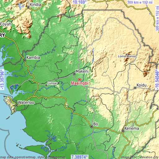
These maps also provides idea of topography and contour of this city, they are displayed at different zoom levels. More info about maps, scale and edge coordinates you can find below images.
| \ | Map #1 | Map #2 | Topo.Map |
| Scale [m] | 74..244 m | 65..262 m | × |
| Scale [ft] | 243..801 ft | 213..860 ft | × |
| Average | 103.9 m = 341 ft | 99.6 m = 327 ft | × |
| Width | 9.66 km = 6 mi | 19.32 km = 12 mi | 309 km = 192 mi |
| Height | 9.66 km = 6 mi | 19.32 km = 12 mi | 309.1 km = 192.1 mi |
| ↑Max Latitude | 8.825398° | 8.86882° | 10.169° |
| Latitude at center | 8.78197° | 8.78197° | 8.78197° |
| ↓Min Latitude | 8.738537° | 8.6951° | 7.38974° |
| ← Min Longitude | -11.995655° | -12.039601° | -13.35796° |
| Longitude center | -11.95171° | -11.95171° | -11.95171° |
| →Max Longitude | -11.907765° | -11.863819° | -10.54546° |
Nearby cities:
Cities around Masingbi sort by population:
• Makeni elevation 93 m
15.4 km,  318°
318°
• Lunsar 64 m
65 km,  260°
260°
• Magburaka 99 m
6.6 km,  177°
177°
• Binkolo 119 m
19.2 km,  350°
350°
• Rokupr 83 m
49.2 km, 255°
• Baiima 69 m
75.8 km,  171°
171°
• Yonibana 77 m
49.2 km,  220°
220°
• Makali 291 m
36.1 km,  117°
117°
• Largo 86 m
60.3 km,  202°
202°
• Bumbuna 127 m
36.9 km,  37°
37°
• Masaka 129 m
20.9 km,  128°
128°
• Alikalia 396 m
74.5 km,  56°
56°
Multilingual:
 En español:
Masingbi elevación 109 m.
 En France:
Masingbi élévation 109 m.
 Auf Deutsch:
Masingbi höhe über dem Meeresspiegel ist 109 m.

Sources and notes:
- [note 1] Map square and city borders are not equal. Map elevation data is calculated only from area inside that square.
- [src 1] Elevation data from geonames database provided with same terms of usage.
- [src 2] The elevation map of Masingbi is generated using elevation data from NASA's 3 arcsec (90m) resolution SRTM data.
- [src 3] Base (background) map © OpenStreetMap contributors tiles are generated by Geofabrik and OpenTopoMap.
Copyright & License:
This Masingbi Elevation Map is licensed under CC BY-SA. You may reuse any part from this page, if you give a proper credit by linking to this URL:
 More info on terms of use page.