Alikalia elevation
Alikalia (Northern Province), Sierra Leone elevation is 396 meters and Alikalia elevation in feet is 1299 ft above sea level [src 1]. Alikalia is a populated place (feature code) with elevation that is 239 meters (784 ft) bigger than average city elevation in Sierra Leone.
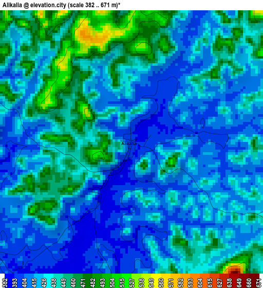
Below is the Elevation map of Alikalia, which displays elevation range with different colors. Scale of the first map is from 382 to 671 m (1253 to 2201 ft) with average elevation of 432.3 meters (=1418 ft) [note 1]
These maps also provides idea of topography and contour of this city, they are displayed at different zoom levels. More info about maps, scale and edge coordinates you can find below images.
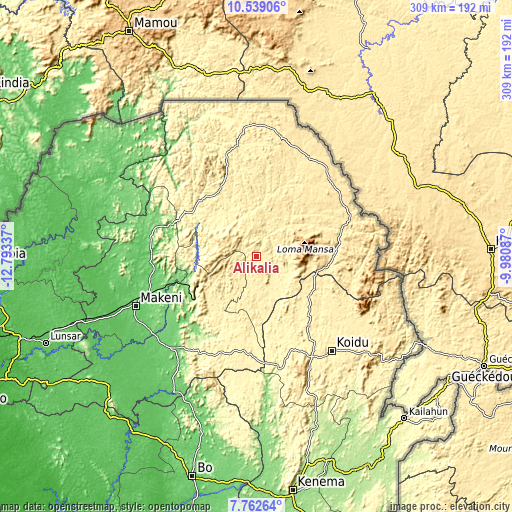
| \ | Map #1 | Topo.Map |
| Scale [m] | 382..671 m | × |
| Scale [ft] | 1253..2201 ft | × |
| Average | 432.3 m = 1418 ft | × |
| Width | 9.65 km = 6 mi | 308.7 km = 191.8 mi |
| Height | 9.65 km = 6 mi | 308.7 km = 191.8 mi |
| ↑Max Latitude | 9.196943° | 10.53906° |
| Latitude at center | 9.15356° | 9.15356° |
| ↓Min Latitude | 9.110172° | 7.76264° |
| ← Min Longitude | -11.431065° | -12.79337° |
| Longitude center | -11.38712° | -11.38712° |
| →Max Longitude | -11.343175° | -9.98087° |
Nearby cities:
Cities around Alikalia sort by population:
• Koidu elevation 381 m
72.8 km,  141°
141°
• Kabala 433 m
51.7 km,  339°
339°
• Binkolo 119 m
68.9 km,  251°
251°
• Yengema 390 m
54.3 km,  154°
154°
• Motema 405 m
72.7 km, 145°
• Makali 291 m
65.6 km,  207°
207°
• Tefeya 333 m
53.5 km,  159°
159°
• Bumbuna 127 m
41.2 km, 252°
• Masaka 129 m
71 km,  220°
220°
• Koyima 385 m
63.9 km, 141°
• Simbakoro 403 m
73.2 km, 145°
• Kayima 373 m
38.7 km, 139°
Multilingual:
 En español:
Alikalia elevación 396 m.
 En France:
Alikalia élévation 396 m.
 Auf Deutsch:
Alikalia höhe über dem Meeresspiegel ist 396 m.

Sources and notes:
- [note 1] Map square and city borders are not equal. Map elevation data is calculated only from area inside that square.
- [src 1] Elevation data from geonames database provided with same terms of usage.
- [src 2] The elevation map of Alikalia is generated using elevation data from NASA's 3 arcsec (90m) resolution SRTM data.
- [src 3] Base (background) map © OpenStreetMap contributors tiles are generated by Geofabrik and OpenTopoMap.
Copyright & License:
This Alikalia Elevation Map is licensed under CC BY-SA. You may reuse any part from this page, if you give a proper credit by linking to this URL:
 More info on terms of use page.