Kukuna elevation
Kukuna (Northern Province), Sierra Leone elevation is 47 meters and Kukuna elevation in feet is 154 ft above sea level [src 1]. Kukuna is a populated place (feature code) with elevation that is 110 meters (361 ft) smaller than average city elevation in Sierra Leone.
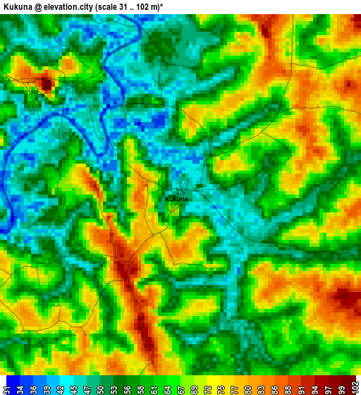
Below is the Elevation map of Kukuna, which displays elevation range with different colors. Scale of the first map is from 31 to 102 m (102 to 335 ft) with average elevation of 61.6 meters (=202 ft) [note 1]
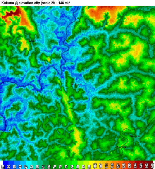
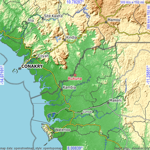
These maps also provides idea of topography and contour of this city, they are displayed at different zoom levels. More info about maps, scale and edge coordinates you can find below images.
| \ | Map #1 | Map #2 | Topo.Map |
| Scale [m] | 31..102 m | 29..148 m | × |
| Scale [ft] | 102..335 ft | 95..486 ft | × |
| Average | 61.6 m = 202 ft | 67.2 m = 220 ft | × |
| Width | 9.64 km = 6 mi | 19.28 km = 12 mi | 308.5 km = 191.7 mi |
| Height | 9.64 km = 6 mi | 19.28 km = 12 mi | 308.5 km = 191.7 mi |
| ↑Max Latitude | 9.441763° | 9.48511° | 10.78287° |
| Latitude at center | 9.39841° | 9.39841° | 9.39841° |
| ↓Min Latitude | 9.355052° | 9.311688° | 8.00839° |
| ← Min Longitude | -12.708705° | -12.752651° | -14.07101° |
| Longitude center | -12.66476° | -12.66476° | -12.66476° |
| →Max Longitude | -12.620815° | -12.576869° | -11.25851° |
Nearby cities:
Cities around Kukuna sort by population:
• Makeni elevation 93 m
88.8 km,  129°
129°
• Lunsar 64 m
80.7 km,  169°
169°
• Port Loko 51 m
71.6 km,  190°
190°
• Binkolo 119 m
90 km,  123°
123°
• Rokupr 83 m
86.5 km,  159°
159°
• Kambia 32 m
41.2 km,  222°
222°
• Kamakwie 116 m
47.8 km,  76°
76°
• Mambolo 18 m
67.2 km, 217°
• Kassiri 15 m
71.2 km, 224°
• Pepel 20 m
99.9 km,  205°
205°
• Loma 139 m
80 km,  59°
59°
• Mange 19 m
57 km,  201°
201°
Multilingual:
 En español:
Kukuna elevación 47 m.
 En France:
Kukuna élévation 47 m.


Sources and notes:
- [note 1] Map square and city borders are not equal. Map elevation data is calculated only from area inside that square.
- [src 1] Elevation data from geonames database provided with same terms of usage.
- [src 2] The elevation map of Kukuna is generated using elevation data from NASA's 3 arcsec (90m) resolution SRTM data.
- [src 3] Base (background) map © OpenStreetMap contributors tiles are generated by Geofabrik and OpenTopoMap.
Copyright & License:
This Kukuna Elevation Map is licensed under CC BY-SA. You may reuse any part from this page, if you give a proper credit by linking to this URL:
 More info on terms of use page.