Stará Ľubovňa elevation
Stará Ľubovňa (Prešovský kraj, Okres Stará Ĺubovňa), Slovakia elevation is 548 meters and Stará Ľubovňa elevation in feet is 1798 ft above sea level [src 1]. Stará Ľubovňa is a seat of a second-order administrative division (feature code) with elevation that is 228 meters (748 ft) bigger than average city elevation in Slovakia.
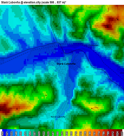
Below is the Elevation map of Stará Ľubovňa, which displays elevation range with different colors. Scale of the first map is from 508 to 837 m (1667 to 2746 ft) with average elevation of 594.8 meters (=1951 ft) [note 1]
These maps also provides idea of topography and contour of this city, they are displayed at different zoom levels. More info about maps, scale and edge coordinates you can find below images.
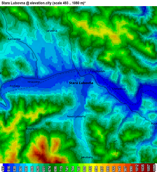
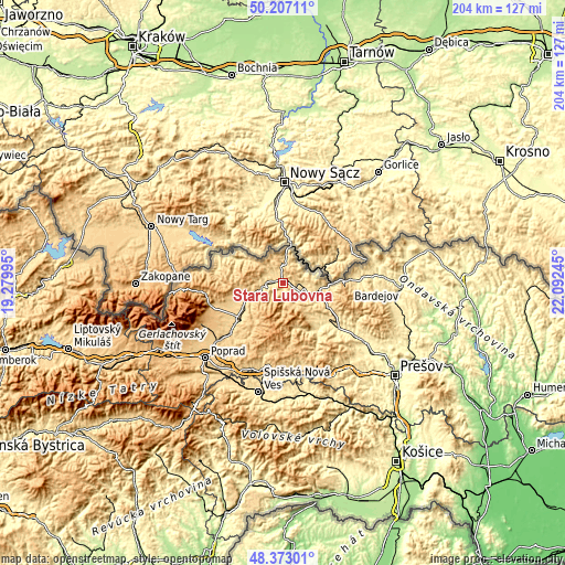
| \ | Map #1 | Map #2 | Topo.Map |
| Scale [m] | 508..837 m | 493..1080 m | × |
| Scale [ft] | 1667..2746 ft | 1617..3543 ft | × |
| Average | 594.8 m = 1951 ft | 653.8 m = 2145 ft | × |
| Width | 6.37 km = 4 mi | 12.75 km = 7.9 mi | 203.9 km = 126.7 mi |
| Height | 6.37 km = 4 mi | 12.75 km = 7.9 mi | 203.9 km = 126.7 mi |
| ↑Max Latitude | 49.327239° | 49.355872° | 50.20711° |
| Latitude at center | 49.29859° | 49.29859° | 49.29859° |
| ↓Min Latitude | 49.269924° | 49.241242° | 48.37301° |
| ← Min Longitude | 20.642255° | 20.598309° | 19.27995° |
| Longitude center | 20.6862° | 20.6862° | 20.6862° |
| →Max Longitude | 20.730145° | 20.774091° | 22.09245° |
Nearby cities:
Cities around Stará Ľubovňa sort by population:
• Kežmarok elevation 615 m
25.8 km,  225°
225°
• Levoča 536 m
31.5 km,  192°
192°
• Spišská Belá 625 m
20.6 km, 233°
• Lipany 387 m
25.8 km,  128°
128°
• Ľubica 633 m
26.5 km,  220°
220°
• Spišské Podhradie 434 m
33.5 km,  171°
171°
• Podolínec 567 m
11.8 km,  247°
247°
• Žehra 418 m
36.3 km, 167°
• Nová Lesná 748 m
36.2 km,  237°
237°
• Vrbov 652 m
30.2 km, 218°
• Ždiar 887 m
30.9 km,  264°
264°
• Vyšné Ružbachy 615 m
8.8 km,  273°
273°
Multilingual:
 En español:
Stará Ľubovňa elevación 548 m.
 En France:
Stará Ľubovňa élévation 548 m.
 Auf Deutsch:
Stará Ľubovňa höhe über dem Meeresspiegel ist 548 m.

Sources and notes:
- [note 1] Map square and city borders are not equal. Map elevation data is calculated only from area inside that square.
- [src 1] Elevation data from geonames database provided with same terms of usage.
- [src 2] The elevation map of Stará Ľubovňa is generated using elevation data from NASA's 3 arcsec (90m) resolution SRTM data.
- [src 3] Base (background) map © OpenStreetMap contributors tiles are generated by Geofabrik and OpenTopoMap.
Copyright & License:
This Stará Ľubovňa Elevation Map is licensed under CC BY-SA. You may reuse any part from this page, if you give a proper credit by linking to this URL:
 More info on terms of use page.