Dobje pri Planini elevation
Dobje pri Planini (Dobje), Slovenia elevation is 563 meters and Dobje pri Planini elevation in feet is 1847 ft above sea level [src 1]. Dobje pri Planini is a seat of a first-order administrative division (feature code) with elevation that is 249 meters (817 ft) bigger than average city elevation in Slovenia.
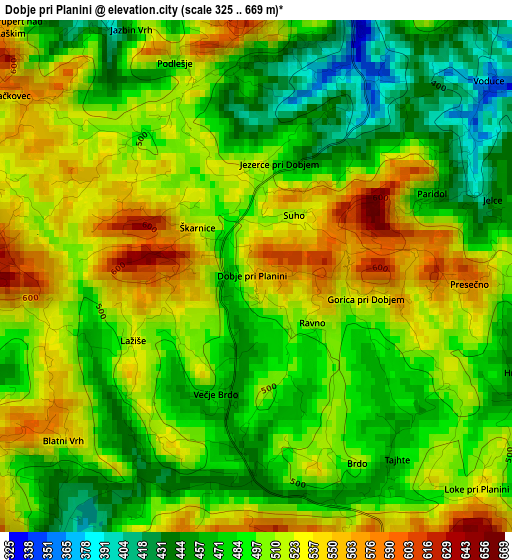
Below is the Elevation map of Dobje pri Planini, which displays elevation range with different colors. Scale of the first map is from 325 to 669 m (1066 to 2195 ft) with average elevation of 500.4 meters (=1642 ft) [note 1]
These maps also provides idea of topography and contour of this city, they are displayed at different zoom levels. More info about maps, scale and edge coordinates you can find below images.
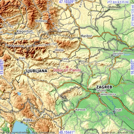
| \ | Map #1 | Topo.Map |
| Scale [m] | 325..669 m | × |
| Scale [ft] | 1066..2195 ft | × |
| Average | 500.4 m = 1642 ft | × |
| Width | 6.77 km = 4.2 mi | 216.7 km = 134.7 mi |
| Height | 6.77 km = 4.2 mi | 216.7 km = 134.7 mi |
| ↑Max Latitude | 46.167913° | 47.10329° |
| Latitude at center | 46.13747° | 46.13747° |
| ↓Min Latitude | 46.107011° | 45.15441° |
| ← Min Longitude | 15.350175° | 13.98787° |
| Longitude center | 15.39412° | 15.39412° |
| →Max Longitude | 15.438065° | 16.80037° |
Nearby cities:
Cities around Dobje pri Planini sort by population:
• Celje elevation 240 m
14.6 km,  315°
315°
• Šentjur 301 m
8.9 km,  1°
1°
• Sevnica 206 m
15.6 km,  202°
202°
• Laško 226 m
12.4 km,  278°
278°
• Senovo 234 m
14.2 km,  153°
153°
• Radeče 196 m
18 km,  244°
244°
• Štore 273 m
11.1 km,  326°
326°
• Šmarje pri Jelšah 239 m
13.9 km,  43°
43°
• Trnovlje pri Celju 246 m
15.3 km, 330°
• Ljubečna 259 m
14.2 km,  337°
337°
• Kozje 285 m
14.6 km,  118°
118°
• Podčetrtek 220 m
15.9 km,  82°
82°
Multilingual:
 En español:
Dobje pri Planini elevación 563 m.
 En France:
Dobje pri Planini élévation 563 m.
 Auf Deutsch:
Dobje pri Planini höhe über dem Meeresspiegel ist 563 m.

Sources and notes:
- [note 1] Map square and city borders are not equal. Map elevation data is calculated only from area inside that square.
- [src 1] Elevation data from geonames database provided with same terms of usage.
- [src 2] The elevation map of Dobje pri Planini is generated using elevation data from NASA's 3 arcsec (90m) resolution SRTM data.
- [src 3] Base (background) map © OpenStreetMap contributors tiles are generated by Geofabrik and OpenTopoMap.
Copyright & License:
This Dobje pri Planini Elevation Map is licensed under CC BY-SA. You may reuse any part from this page, if you give a proper credit by linking to this URL:
 More info on terms of use page.