Celje elevation
Celje, Slovenia elevation is 240 meters and Celje elevation in feet is 787 ft above sea level [src 1]. Celje is a seat of a first-order administrative division (feature code) with elevation that is 74 meters (243 ft) smaller than average city elevation in Slovenia.
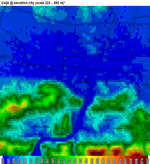
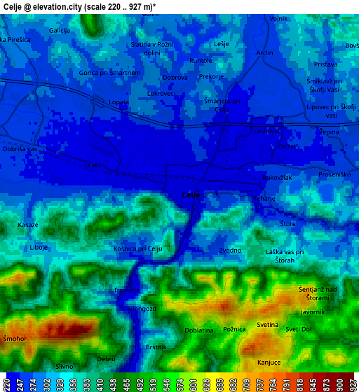
Below is the Elevation map of Celje, which displays elevation range with different colors. Scale of the first map is from 223 to 692 m (732 to 2270 ft) with average elevation of 293.9 meters (=964 ft) [note 1]
These maps also provides idea of topography and contour of this city, they are displayed at different zoom levels. More info about maps, scale and edge coordinates you can find below images.
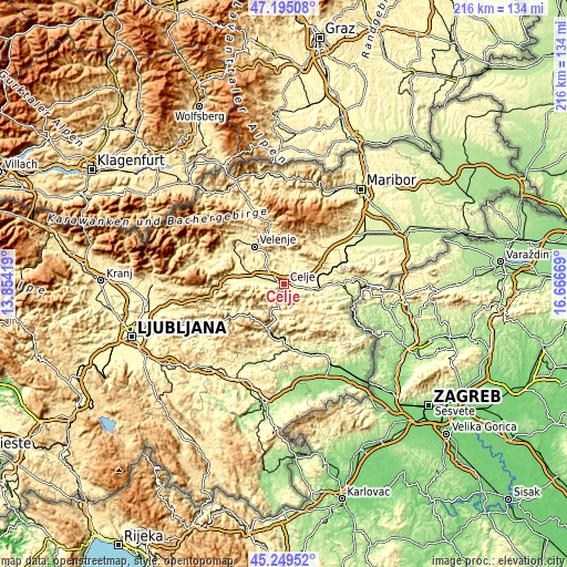
| \ | Map #1 | Map #2 | Topo.Map |
| Scale [m] | 223..692 m | 220..927 m | × |
| Scale [ft] | 732..2270 ft | 722..3041 ft | × |
| Average | 293.9 m = 964 ft | 355 m = 1165 ft | × |
| Width | 6.76 km = 4.2 mi | 13.52 km = 8.4 mi | 216.3 km = 134.4 mi |
| Height | 6.76 km = 4.2 mi | 13.52 km = 8.4 mi | 216.3 km = 134.4 mi |
| ↑Max Latitude | 46.261311° | 46.291685° | 47.19508° |
| Latitude at center | 46.23092° | 46.23092° | 46.23092° |
| ↓Min Latitude | 46.200512° | 46.170088° | 45.24952° |
| ← Min Longitude | 15.216495° | 15.172549° | 13.85419° |
| Longitude center | 15.26044° | 15.26044° | 15.26044° |
| →Max Longitude | 15.304385° | 15.348331° | 16.66669° |
Nearby cities:
Cities around Celje sort by population:
• Žalec elevation 260 m
7.7 km,  287°
287°
• Šentjur 301 m
10.7 km,  98°
98°
• Laško 226 m
8.7 km,  192°
192°
• Vojnik 274 m
7.7 km,  25°
25°
• Šempeter v Savinj. Dolini 271 m
11 km,  284°
284°
• Štore 273 m
4.3 km,  105°
105°
• Prebold 283 m
12.9 km,  272°
272°
• Trnovlje pri Celju 246 m
3.9 km,  43°
43°
• Gotovlje 323 m
9.6 km,  299°
299°
• Ljubečna 259 m
5.6 km,  60°
60°
• Zabukovica 330 m
8 km,  256°
256°
• Dobrna 381 m
12.1 km,  347°
347°
Multilingual:
 En español:
Celje elevación 240 m.
 En France:
Celje élévation 240 m.


Sources and notes:
- [note 1] Map square and city borders are not equal. Map elevation data is calculated only from area inside that square.
- [src 1] Elevation data from geonames database provided with same terms of usage.
- [src 2] The elevation map of Celje is generated using elevation data from NASA's 3 arcsec (90m) resolution SRTM data.
- [src 3] Base (background) map © OpenStreetMap contributors tiles are generated by Geofabrik and OpenTopoMap.
Copyright & License:
This Celje Elevation Map is licensed under CC BY-SA. You may reuse any part from this page, if you give a proper credit by linking to this URL:
 More info on terms of use page.