Kobilje elevation
Kobilje, Slovenia elevation is 183 meters and Kobilje elevation in feet is 600 ft above sea level [src 1]. Kobilje is a seat of a first-order administrative division (feature code) with elevation that is 131 meters (430 ft) smaller than average city elevation in Slovenia.
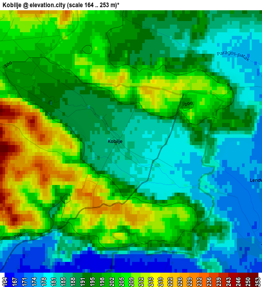
Below is the Elevation map of Kobilje, which displays elevation range with different colors. Scale of the first map is from 164 to 253 m (538 to 830 ft) with average elevation of 195.1 meters (=640 ft) [note 1]
These maps also provides idea of topography and contour of this city, they are displayed at different zoom levels. More info about maps, scale and edge coordinates you can find below images.
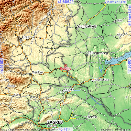
| \ | Map #1 | Topo.Map |
| Scale [m] | 164..253 m | × |
| Scale [ft] | 538..830 ft | × |
| Average | 195.1 m = 640 ft | × |
| Width | 6.7 km = 4.2 mi | 214.5 km = 133.3 mi |
| Height | 6.7 km = 4.2 mi | 214.5 km = 133.3 mi |
| ↑Max Latitude | 46.714859° | 47.64082° |
| Latitude at center | 46.68472° | 46.68472° |
| ↓Min Latitude | 46.654565° | 45.7114° |
| ← Min Longitude | 16.353835° | 14.99153° |
| Longitude center | 16.39778° | 16.39778° |
| →Max Longitude | 16.441725° | 17.80403° |
Nearby cities:
Cities around Kobilje sort by population:
• Lendava elevation 164 m
13.9 km,  163°
163°
• Beltinci 177 m
14.9 km,  233°
233°
• Odranci 175 m
14.1 km,  219°
219°
• Rakičan 185 m
15.2 km,  256°
256°
• Turnišče 172 m
8.7 km, 223°
• Črenšovci 173 m
15.8 km,  206°
206°
• Lipovci 179 m
14.4 km,  244°
244°
• Gančani 186 m
12.6 km, 242°
• Dobrovnik 174 m
5.1 km, 222°
• Velika Polana 165 m
13.1 km,  197°
197°
• Moravske Toplice 188 m
13.5 km,  269°
269°
• Hodoš 234 m
16.2 km,  342°
342°
Multilingual:
 En español:
Kobilje elevación 183 m.
 En France:
Kobilje élévation 183 m.
 Auf Deutsch:
Brezovica höhe über dem Meeresspiegel ist 183 m.

Sources and notes:
- [note 1] Map square and city borders are not equal. Map elevation data is calculated only from area inside that square.
- [src 1] Elevation data from geonames database provided with same terms of usage.
- [src 2] The elevation map of Kobilje is generated using elevation data from NASA's 3 arcsec (90m) resolution SRTM data.
- [src 3] Base (background) map © OpenStreetMap contributors tiles are generated by Geofabrik and OpenTopoMap.
Copyright & License:
This Kobilje Elevation Map is licensed under CC BY-SA. You may reuse any part from this page, if you give a proper credit by linking to this URL:
 More info on terms of use page.