Beltinci elevation
Beltinci, Slovenia elevation is 177 meters and Beltinci elevation in feet is 581 ft above sea level [src 1]. Beltinci is a seat of a first-order administrative division (feature code) with elevation that is 137 meters (449 ft) smaller than average city elevation in Slovenia.
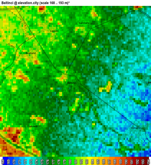
Below is the Elevation map of Beltinci, which displays elevation range with different colors. Scale of the first map is from 168 to 193 m (551 to 633 ft) with average elevation of 176.8 meters (=580 ft) [note 1]
These maps also provides idea of topography and contour of this city, they are displayed at different zoom levels. More info about maps, scale and edge coordinates you can find below images.
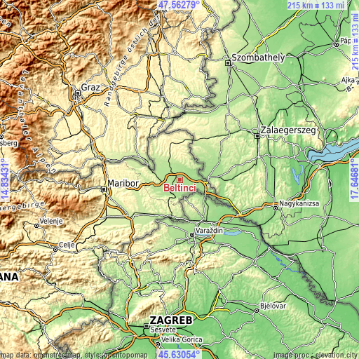
| \ | Map #1 | Topo.Map |
| Scale [m] | 168..193 m | × |
| Scale [ft] | 551..633 ft | × |
| Average | 176.8 m = 580 ft | × |
| Width | 6.71 km = 4.2 mi | 214.8 km = 133.5 mi |
| Height | 6.71 km = 4.2 mi | 214.8 km = 133.5 mi |
| ↑Max Latitude | 46.635463° | 47.56279° |
| Latitude at center | 46.60528° | 46.60528° |
| ↓Min Latitude | 46.57508° | 45.63054° |
| ← Min Longitude | 16.196615° | 14.83431° |
| Longitude center | 16.24056° | 16.24056° |
| →Max Longitude | 16.284505° | 17.64681° |
Nearby cities:
Cities around Beltinci sort by population:
• Murska Sobota elevation 192 m
8.5 km,  318°
318°
• Odranci 175 m
3.7 km,  124°
124°
• Rakičan 185 m
5.9 km,  331°
331°
• Turnišče 172 m
6.6 km,  67°
67°
• Bakovci 185 m
7.1 km,  282°
282°
• Črenšovci 173 m
7.2 km,  137°
137°
• Krog 188 m
8.4 km,  295°
295°
• Lipovci 179 m
2.7 km,  339°
339°
• Gančani 186 m
3.1 km,  14°
14°
• Veržej 182 m
6.2 km,  247°
247°
• Moravske Toplice 188 m
8.8 km,  350°
350°
• Križevci pri Ljutomeru 185 m
8.8 km,  242°
242°
Multilingual:
 En español:
Beltinci elevación 177 m.
 En France:
Beltinci élévation 177 m.
 Auf Deutsch:
Beltinci höhe über dem Meeresspiegel ist 177 m.

Sources and notes:
- [note 1] Map square and city borders are not equal. Map elevation data is calculated only from area inside that square.
- [src 1] Elevation data from geonames database provided with same terms of usage.
- [src 2] The elevation map of Beltinci is generated using elevation data from NASA's 3 arcsec (90m) resolution SRTM data.
- [src 3] Base (background) map © OpenStreetMap contributors tiles are generated by Geofabrik and OpenTopoMap.
Copyright & License:
This Beltinci Elevation Map is licensed under CC BY-SA. You may reuse any part from this page, if you give a proper credit by linking to this URL:
 More info on terms of use page.