Rakičan elevation
Rakičan (Murska Sobota), Slovenia elevation is 185 meters and Rakičan elevation in feet is 607 ft above sea level [src 1]. Rakičan is a populated place (feature code) with elevation that is 129 meters (423 ft) smaller than average city elevation in Slovenia.
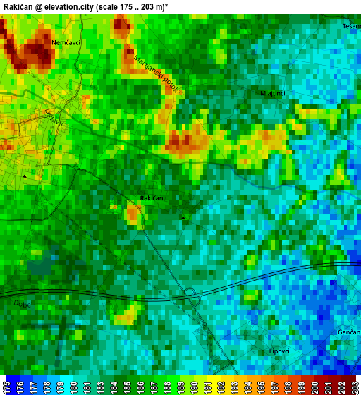
Below is the Elevation map of Rakičan, which displays elevation range with different colors. Scale of the first map is from 175 to 203 m (574 to 666 ft) with average elevation of 184.5 meters (=605 ft) [note 1]
These maps also provides idea of topography and contour of this city, they are displayed at different zoom levels. More info about maps, scale and edge coordinates you can find below images.
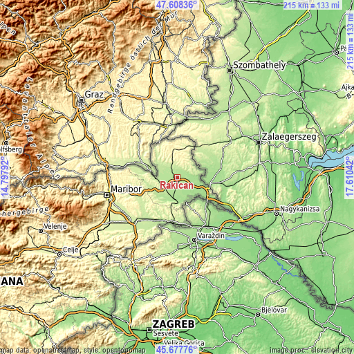
| \ | Map #1 | Topo.Map |
| Scale [m] | 175..203 m | × |
| Scale [ft] | 574..666 ft | × |
| Average | 184.5 m = 605 ft | × |
| Width | 6.71 km = 4.2 mi | 214.7 km = 133.4 mi |
| Height | 6.71 km = 4.2 mi | 214.7 km = 133.4 mi |
| ↑Max Latitude | 46.681827° | 47.60836° |
| Latitude at center | 46.65167° | 46.65167° |
| ↓Min Latitude | 46.621496° | 45.67776° |
| ← Min Longitude | 16.160225° | 14.79792° |
| Longitude center | 16.20417° | 16.20417° |
| →Max Longitude | 16.248115° | 17.61042° |
Nearby cities:
Cities around Rakičan sort by population:
• Murska Sobota elevation 192 m
3.1 km,  292°
292°
• Beltinci 177 m
5.9 km,  151°
151°
• Turnišče 172 m
9.3 km,  106°
106°
• Bakovci 185 m
5.5 km,  228°
228°
• Černelavci 192 m
5.7 km, 287°
• Krog 188 m
5 km,  252°
252°
• Lipovci 179 m
3.2 km,  144°
144°
• Gančani 186 m
4.2 km,  120°
120°
• Veržej 182 m
8.1 km,  201°
201°
• Moravske Toplice 188 m
3.7 km,  19°
19°
• Puconci 205 m
7.1 km,  329°
329°
• Tišina 192 m
8.6 km,  274°
274°
Multilingual:
 En español:
Rakičan elevación 185 m.
 En France:
Rakičan élévation 185 m.


Sources and notes:
- [note 1] Map square and city borders are not equal. Map elevation data is calculated only from area inside that square.
- [src 1] Elevation data from geonames database provided with same terms of usage.
- [src 2] The elevation map of Rakičan is generated using elevation data from NASA's 3 arcsec (90m) resolution SRTM data.
- [src 3] Base (background) map © OpenStreetMap contributors tiles are generated by Geofabrik and OpenTopoMap.
Copyright & License:
This Rakičan Elevation Map is licensed under CC BY-SA. You may reuse any part from this page, if you give a proper credit by linking to this URL:
 More info on terms of use page.