Kočevje elevation
Kočevje, Slovenia elevation is 471 meters and Kočevje elevation in feet is 1545 ft above sea level [src 1]. Kočevje is a seat of a first-order administrative division (feature code) with elevation that is 157 meters (515 ft) bigger than average city elevation in Slovenia.
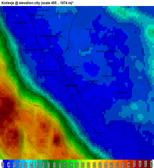
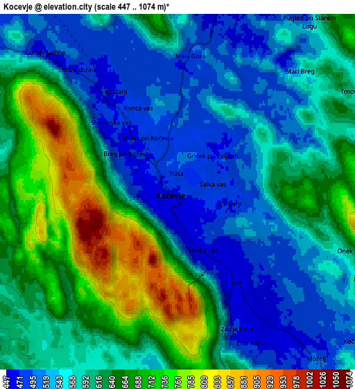
Below is the Elevation map of Kočevje, which displays elevation range with different colors. Scale of the first map is from 455 to 1074 m (1493 to 3524 ft) with average elevation of 578.6 meters (=1898 ft) [note 1]
These maps also provides idea of topography and contour of this city, they are displayed at different zoom levels. More info about maps, scale and edge coordinates you can find below images.
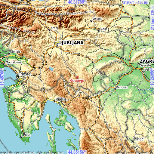
| \ | Map #1 | Map #2 | Topo.Map |
| Scale [m] | 455..1074 m | 447..1074 m | × |
| Scale [ft] | 1493..3524 ft | 1467..3524 ft | × |
| Average | 578.6 m = 1898 ft | 600.5 m = 1970 ft | × |
| Width | 6.83 km = 4.2 mi | 13.66 km = 8.5 mi | 218.6 km = 135.8 mi |
| Height | 6.83 km = 4.2 mi | 13.66 km = 8.5 mi | 218.6 km = 135.8 mi |
| ↑Max Latitude | 45.674045° | 45.704743° | 46.61785° |
| Latitude at center | 45.64333° | 45.64333° | 45.64333° |
| ↓Min Latitude | 45.612598° | 45.58185° | 44.65156° |
| ← Min Longitude | 14.819385° | 14.775439° | 13.45708° |
| Longitude center | 14.86333° | 14.86333° | 14.86333° |
| →Max Longitude | 14.907275° | 14.951221° | 16.26958° |
Nearby cities:
Cities around Kočevje sort by population:
• Črnomelj elevation 150 m
26.6 km,  107°
107°
• Ribnica 495 m
15 km,  315°
315°
• Semič 214 m
24.8 km,  89°
89°
• Straža 170 m
22.3 km,  46°
46°
• Žužemberk 233 m
21.8 km,  13°
13°
• Sodražica 542 m
22 km,  306°
306°
• Dolenjske Toplice 178 m
19.7 km, 50°
• Videm 439 m
26.5 km,  330°
330°
• Hrib-Loški Potok 797 m
20.4 km,  290°
290°
• Osilnica 298 m
18.1 km,  225°
225°
• Kostel 357 m
15.4 km,  166°
166°
• Loški Potok 831 m
22.9 km, 286°
Multilingual:
 En español:
Kočevje elevación 471 m.
 En France:
Kočevje élévation 471 m.
 Auf Deutsch:
Gottschee, Kočevje höhe über dem Meeresspiegel ist 471 m.

Sources and notes:
- [note 1] Map square and city borders are not equal. Map elevation data is calculated only from area inside that square.
- [src 1] Elevation data from geonames database provided with same terms of usage.
- [src 2] The elevation map of Kočevje is generated using elevation data from NASA's 3 arcsec (90m) resolution SRTM data.
- [src 3] Base (background) map © OpenStreetMap contributors tiles are generated by Geofabrik and OpenTopoMap.
Copyright & License:
This Kočevje Elevation Map is licensed under CC BY-SA. You may reuse any part from this page, if you give a proper credit by linking to this URL:
 More info on terms of use page.