Ribnica elevation
Ribnica, Slovenia elevation is 495 meters and Ribnica elevation in feet is 1624 ft above sea level [src 1]. Ribnica is a seat of a first-order administrative division (feature code) with elevation that is 181 meters (594 ft) bigger than average city elevation in Slovenia.
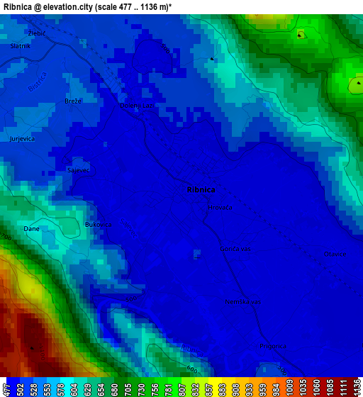
Below is the Elevation map of Ribnica, which displays elevation range with different colors. Scale of the first map is from 477 to 1136 m (1565 to 3727 ft) with average elevation of 564.9 meters (=1853 ft) [note 1]
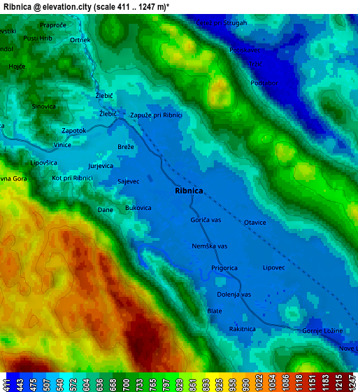
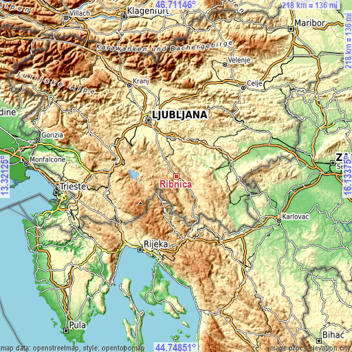
These maps also provides idea of topography and contour of this city, they are displayed at different zoom levels. More info about maps, scale and edge coordinates you can find below images.
| \ | Map #1 | Map #2 | Topo.Map |
| Scale [m] | 477..1136 m | 411..1247 m | × |
| Scale [ft] | 1565..3727 ft | 1348..4091 ft | × |
| Average | 564.9 m = 1853 ft | 664.6 m = 2180 ft | × |
| Width | 6.82 km = 4.2 mi | 13.64 km = 8.5 mi | 218.3 km = 135.6 mi |
| Height | 6.82 km = 4.2 mi | 13.64 km = 8.5 mi | 218.2 km = 135.6 mi |
| ↑Max Latitude | 45.769272° | 45.799918° | 46.71146° |
| Latitude at center | 45.73861° | 45.73861° | 45.73861° |
| ↓Min Latitude | 45.707931° | 45.677235° | 44.74851° |
| ← Min Longitude | 14.683555° | 14.639609° | 13.32125° |
| Longitude center | 14.7275° | 14.7275° | 14.7275° |
| →Max Longitude | 14.771445° | 14.815391° | 16.13375° |
Nearby cities:
Cities around Ribnica sort by population:
• Kočevje elevation 471 m
15 km,  135°
135°
• Grosuplje 344 m
24.7 km,  347°
347°
• Ivančna Gorica 327 m
23 km,  15°
15°
• Žužemberk 233 m
18.9 km,  55°
55°
• Sodražica 542 m
7.6 km,  289°
289°
• Velike Lašče 537 m
12.6 km,  325°
325°
• Videm 439 m
12.7 km, 348°
• Leskova Dolina 834 m
24.5 km,  237°
237°
• Hrib-Loški Potok 797 m
9.3 km,  247°
247°
• Nova Vas 721 m
17.6 km,  282°
282°
• Osilnica 298 m
23.4 km,  185°
185°
• Loški Potok 831 m
12.2 km, 250°
Multilingual:
 En español:
Ribnica elevación 495 m.
 En France:
Ribnica élévation 495 m.
 Auf Deutsch:
Reifnitz höhe über dem Meeresspiegel ist 495 m.

Sources and notes:
- [note 1] Map square and city borders are not equal. Map elevation data is calculated only from area inside that square.
- [src 1] Elevation data from geonames database provided with same terms of usage.
- [src 2] The elevation map of Ribnica is generated using elevation data from NASA's 3 arcsec (90m) resolution SRTM data.
- [src 3] Base (background) map © OpenStreetMap contributors tiles are generated by Geofabrik and OpenTopoMap.
Copyright & License:
This Ribnica Elevation Map is licensed under CC BY-SA. You may reuse any part from this page, if you give a proper credit by linking to this URL:
 More info on terms of use page.