Solčava elevation
Solčava, Slovenia elevation is 642 meters and Solčava elevation in feet is 2106 ft above sea level [src 1]. Solčava is a seat of a first-order administrative division (feature code) with elevation that is 328 meters (1076 ft) bigger than average city elevation in Slovenia.
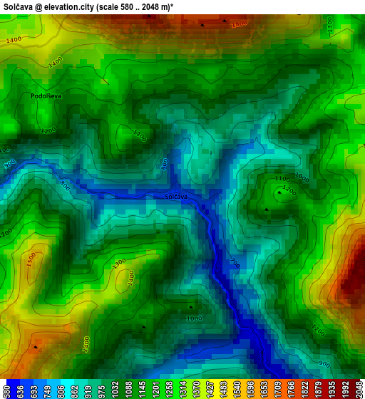
Below is the Elevation map of Solčava, which displays elevation range with different colors. Scale of the first map is from 580 to 2048 m (1903 to 6719 ft) with average elevation of 1126.2 meters (=3695 ft) [note 1]
These maps also provides idea of topography and contour of this city, they are displayed at different zoom levels. More info about maps, scale and edge coordinates you can find below images.
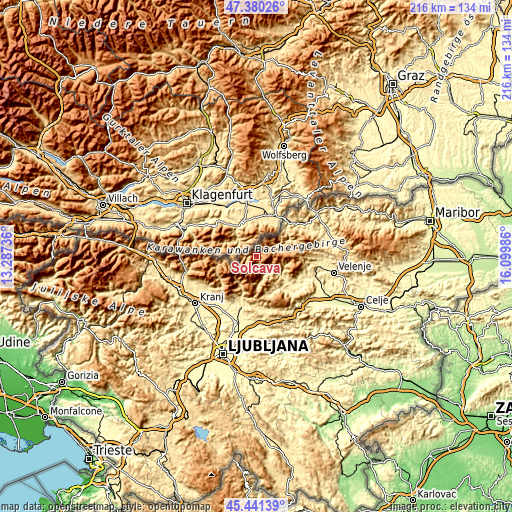
| \ | Map #1 | Topo.Map |
| Scale [m] | 580..2048 m | × |
| Scale [ft] | 1903..6719 ft | × |
| Average | 1126.2 m = 3695 ft | × |
| Width | 6.74 km = 4.2 mi | 215.6 km = 134 mi |
| Height | 6.74 km = 4.2 mi | 215.6 km = 134 mi |
| ↑Max Latitude | 46.449726° | 47.38026° |
| Latitude at center | 46.41944° | 46.41944° |
| ↓Min Latitude | 46.389137° | 45.44139° |
| ← Min Longitude | 14.649665° | 13.28736° |
| Longitude center | 14.69361° | 14.69361° |
| →Max Longitude | 14.737555° | 16.09986° |
Nearby cities:
Cities around Solčava sort by population:
• Kamnik elevation 385 m
22.4 km,  196°
196°
• Prevalje 409 m
22.4 km,  50°
50°
• Mežica 480 m
16.7 km, 47°
• Črna na Koroškem 574 m
13.3 km,  64°
64°
• Mozirje 337 m
22.5 km,  113°
113°
• Mekinje 426 m
21.5 km, 195°
• Ljubno ob Savinji 430 m
13.7 km,  128°
128°
• Gornji Grad 434 m
16.4 km,  147°
147°
• Nazarje 347 m
22.5 km,  120°
120°
• Zgornje Jezersko 985 m
14.6 km,  258°
258°
• Rečica ob Savinji 360 m
20.6 km, 123°
• Luče 516 m
8.1 km, 149°
Multilingual:
 En español:
Solčava elevación 642 m.
 En France:
Solčava élévation 642 m.
 Auf Deutsch:
Sulzbach höhe über dem Meeresspiegel ist 642 m.

Sources and notes:
- [note 1] Map square and city borders are not equal. Map elevation data is calculated only from area inside that square.
- [src 1] Elevation data from geonames database provided with same terms of usage.
- [src 2] The elevation map of Solčava is generated using elevation data from NASA's 3 arcsec (90m) resolution SRTM data.
- [src 3] Base (background) map © OpenStreetMap contributors tiles are generated by Geofabrik and OpenTopoMap.
Copyright & License:
This Solčava Elevation Map is licensed under CC BY-SA. You may reuse any part from this page, if you give a proper credit by linking to this URL:
 More info on terms of use page.