Prevalje elevation
Prevalje, Slovenia elevation is 409 meters and Prevalje elevation in feet is 1342 ft above sea level [src 1]. Prevalje is a seat of a first-order administrative division (feature code) with elevation that is 95 meters (312 ft) bigger than average city elevation in Slovenia.
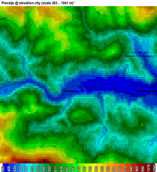
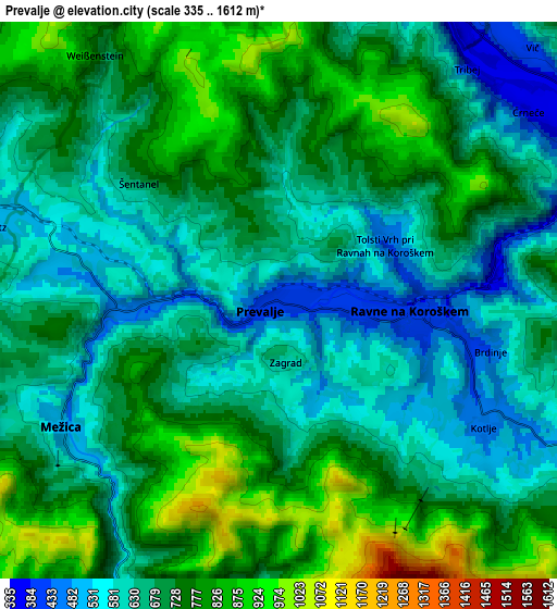
Below is the Elevation map of Prevalje, which displays elevation range with different colors. Scale of the first map is from 383 to 1041 m (1257 to 3415 ft) with average elevation of 590.5 meters (=1937 ft) [note 1]
These maps also provides idea of topography and contour of this city, they are displayed at different zoom levels. More info about maps, scale and edge coordinates you can find below images.
| \ | Map #1 | Map #2 | Topo.Map |
| Scale [m] | 383..1041 m | 335..1612 m | × |
| Scale [ft] | 1257..3415 ft | 1099..5289 ft | × |
| Average | 590.5 m = 1937 ft | 694.3 m = 2278 ft | × |
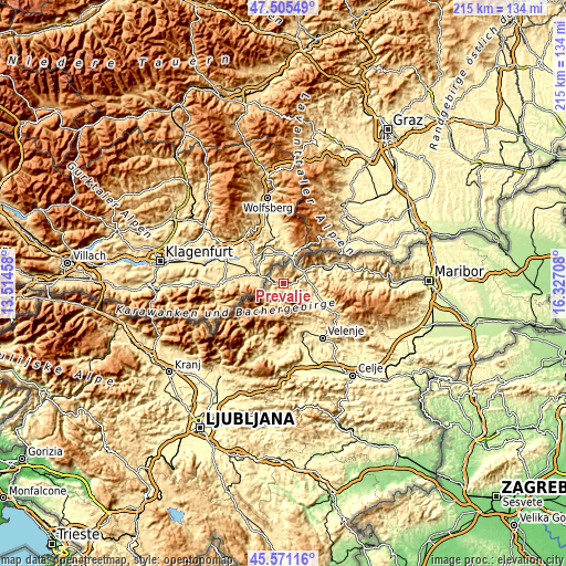
| Width | 6.72 km = 4.2 mi | 13.44 km = 8.4 mi | 215.1 km = 133.7 mi |
| Height | 6.72 km = 4.2 mi | 13.44 km = 8.4 mi | 215.1 km = 133.7 mi |
| ↑Max Latitude | 46.577155° | 46.607354° | 47.50549° |
| Latitude at center | 46.54694° | 46.54694° | 46.54694° |
| ↓Min Latitude | 46.516708° | 46.486459° | 45.57116° |
| ← Min Longitude | 14.876885° | 14.832939° | 13.51458° |
| Longitude center | 14.92083° | 14.92083° | 14.92083° |
| →Max Longitude | 14.964775° | 15.008721° | 16.32708° |
Nearby cities:
Cities around Prevalje sort by population:
• Slovenj Gradec elevation 409 m
12.9 km,  108°
108°
• Ravne na Koroškem 413 m
3.7 km,  96°
96°
• Dravograd 357 m
8.8 km,  58°
58°
• Mežica 480 m
5.8 km,  240°
240°
• Črna na Koroškem 574 m
10.1 km,  212°
212°
• Vuzenica 350 m
19.6 km,  73°
73°
• Pameče 403 m
12.2 km, 96°
• Topolšica 371 m
18 km,  154°
154°
• Šmartno pri Slovenj Gradcu 439 m
15.6 km, 114°
• Ravne 448 m
18.2 km,  144°
144°
• Legen 828 m
17.7 km, 104°
• Kotlje 447 m
5.8 km,  119°
119°
Multilingual:
 En español:
Prevalje elevación 409 m.
 En France:
Prevalje élévation 409 m.
 Auf Deutsch:
Prevalje höhe über dem Meeresspiegel ist 409 m.

Sources and notes:
- [note 1] Map square and city borders are not equal. Map elevation data is calculated only from area inside that square.
- [src 1] Elevation data from geonames database provided with same terms of usage.
- [src 2] The elevation map of Prevalje is generated using elevation data from NASA's 3 arcsec (90m) resolution SRTM data.
- [src 3] Base (background) map © OpenStreetMap contributors tiles are generated by Geofabrik and OpenTopoMap.
Copyright & License:
This Prevalje Elevation Map is licensed under CC BY-SA. You may reuse any part from this page, if you give a proper credit by linking to this URL:
 More info on terms of use page.