Pameče elevation
Pameče (Slovenj Gradec), Slovenia elevation is 403 meters and Pameče elevation in feet is 1322 ft above sea level [src 1]. Pameče is a populated locality (feature code) with elevation that is 89 meters (292 ft) bigger than average city elevation in Slovenia.
Below is the Elevation map of Pameče, which displays elevation range with different colors. Scale of the first map is from 348 to 989 m (1142 to 3245 ft) with average elevation of 538.5 meters (=1767 ft) [note 1]
These maps also provides idea of topography and contour of this city, they are displayed at different zoom levels. More info about maps, scale and edge coordinates you can find below images.
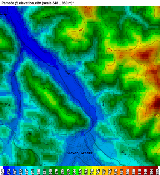
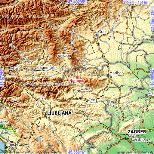
| \ | Map #1 | Topo.Map |
| Scale [m] | 348..989 m | × |
| Scale [ft] | 1142..3245 ft | × |
| Average | 538.5 m = 1767 ft | × |
| Width | 6.72 km = 4.2 mi | 215.1 km = 133.7 mi |
| Height | 6.72 km = 4.2 mi | 215.1 km = 133.7 mi |
| ↑Max Latitude | 46.564393° | 47.49295° |
| Latitude at center | 46.53417° | 46.53417° |
| ↓Min Latitude | 46.503931° | 45.55816° |
| ← Min Longitude | 15.035225° | 13.67292° |
| Longitude center | 15.07917° | 15.07917° |
| →Max Longitude | 15.123115° | 16.48542° |
Nearby cities:
Cities around Pameče sort by population:
• Slovenj Gradec elevation 409 m
2.7 km,  177°
177°
• Ravne na Koroškem 413 m
8.5 km,  276°
276°
• Prevalje 409 m
12.2 km, 276°
• Dravograd 357 m
7.5 km,  322°
322°
• Radlje ob Dravi 366 m
14.3 km,  51°
51°
• Muta 334 m
10.9 km,  37°
37°
• Mislinja 617 m
13.9 km,  138°
138°
• Vuzenica 350 m
9.7 km, 44°
• Šmartno pri Slovenj Gradcu 439 m
5.4 km,  157°
157°
• Ravne 448 m
13.4 km,  185°
185°
• Kotlje 447 m
7.2 km,  258°
258°
• Legen 828 m
5.9 km,  121°
121°
Multilingual:
 En español:
Pameče elevación 403 m.
 En France:
Pameče élévation 403 m.


Sources and notes:
- [note 1] Map square and city borders are not equal. Map elevation data is calculated only from area inside that square.
- [src 1] Elevation data from geonames database provided with same terms of usage.
- [src 2] The elevation map of Pameče is generated using elevation data from NASA's 3 arcsec (90m) resolution SRTM data.
- [src 3] Base (background) map © OpenStreetMap contributors tiles are generated by Geofabrik and OpenTopoMap.
Copyright & License:
This Pameče Elevation Map is licensed under CC BY-SA. You may reuse any part from this page, if you give a proper credit by linking to this URL:
 More info on terms of use page.