Ljubno ob Savinji elevation
Ljubno ob Savinji (Ljubno), Slovenia elevation is 430 meters and Ljubno ob Savinji elevation in feet is 1411 ft above sea level [src 1]. Ljubno ob Savinji is a seat of a first-order administrative division (feature code) with elevation that is 116 meters (381 ft) bigger than average city elevation in Slovenia.
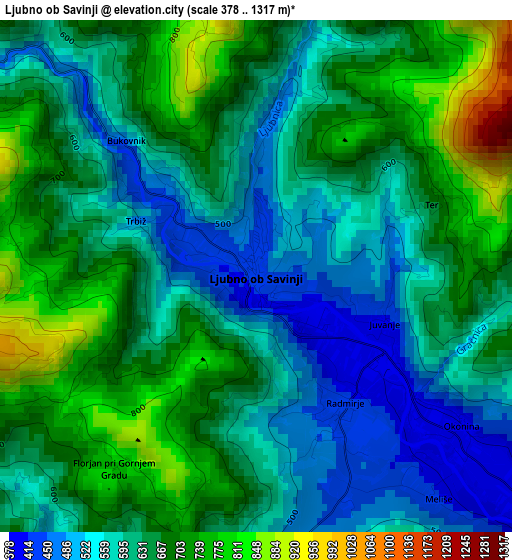
Below is the Elevation map of Ljubno ob Savinji, which displays elevation range with different colors. Scale of the first map is from 378 to 1317 m (1240 to 4321 ft) with average elevation of 629.9 meters (=2067 ft) [note 1]
These maps also provides idea of topography and contour of this city, they are displayed at different zoom levels. More info about maps, scale and edge coordinates you can find below images.
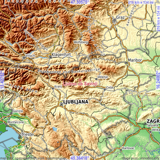
| \ | Map #1 | Topo.Map |
| Scale [m] | 378..1317 m | × |
| Scale [ft] | 1240..4321 ft | × |
| Average | 629.9 m = 2067 ft | × |
| Width | 6.75 km = 4.2 mi | 215.9 km = 134.2 mi |
| Height | 6.75 km = 4.2 mi | 215.9 km = 134.2 mi |
| ↑Max Latitude | 46.373908° | 47.30575° |
| Latitude at center | 46.34358° | 46.34358° |
| ↓Min Latitude | 46.313235° | 45.36418° |
| ← Min Longitude | 14.789825° | 13.42752° |
| Longitude center | 14.83377° | 14.83377° |
| →Max Longitude | 14.877715° | 16.24002° |
Nearby cities:
Cities around Ljubno ob Savinji sort by population:
• Šoštanj elevation 361 m
17 km,  76°
76°
• Črna na Koroškem 574 m
14.2 km,  5°
5°
• Mozirje 337 m
10 km,  92°
92°
• Topolšica 371 m
15.7 km,  66°
66°
• Gornji Grad 434 m
5.7 km,  199°
199°
• Nazarje 347 m
9.1 km,  108°
108°
• Vransko 342 m
14.3 km,  140°
140°
• Šmartno ob Paki 322 m
15.4 km, 94°
• Rečica ob Savinji 360 m
7 km,  115°
115°
• Luče 516 m
6.8 km,  281°
281°
• Braslovče 302 m
16.9 km, 110°
• Solčava 642 m
13.7 km,  308°
308°
Multilingual:
 En español:
Ljubno ob Savinji elevación 430 m.
 En France:
Ljubno ob Savinji élévation 430 m.
 Auf Deutsch:
Ljubno ob Savinji höhe über dem Meeresspiegel ist 430 m.

Sources and notes:
- [note 1] Map square and city borders are not equal. Map elevation data is calculated only from area inside that square.
- [src 1] Elevation data from geonames database provided with same terms of usage.
- [src 2] The elevation map of Ljubno ob Savinji is generated using elevation data from NASA's 3 arcsec (90m) resolution SRTM data.
- [src 3] Base (background) map © OpenStreetMap contributors tiles are generated by Geofabrik and OpenTopoMap.
Copyright & License:
This Ljubno ob Savinji Elevation Map is licensed under CC BY-SA. You may reuse any part from this page, if you give a proper credit by linking to this URL:
 More info on terms of use page.