Charlottenberg elevation
Charlottenberg (Värmland, Eda kommun), Sweden elevation is 134 meters and Charlottenberg elevation in feet is 440 ft above sea level [src 1]. Charlottenberg is a seat of a second-order administrative division (feature code) with elevation that is 59 meters (194 ft) bigger than average city elevation in Sweden.
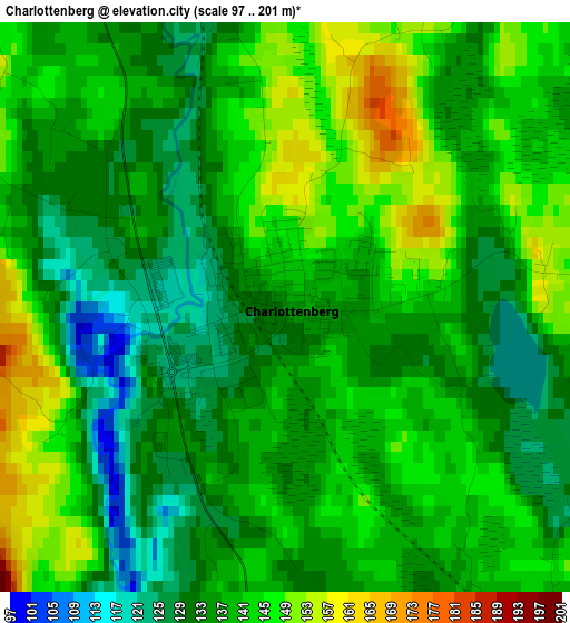
Below is the Elevation map of Charlottenberg, which displays elevation range with different colors. Scale of the first map is from 97 to 201 m (318 to 659 ft) with average elevation of 138.3 meters (=454 ft) [note 1]
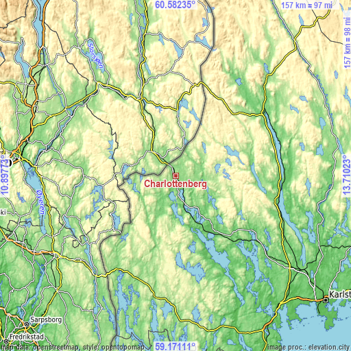
These maps also provides idea of topography and contour of this city, they are displayed at different zoom levels. More info about maps, scale and edge coordinates you can find below images.
| \ | Map #1 | Topo.Map |
| Scale [m] | 97..201 m | × |
| Scale [ft] | 318..659 ft | × |
| Average | 138.3 m = 454 ft | × |
| Width | 4.9 km = 3 mi | 156.9 km = 97.5 mi |
| Height | 4.9 km = 3 mi | 156.9 km = 97.5 mi |
| ↑Max Latitude | 59.906262° | 60.58235° |
| Latitude at center | 59.88422° | 59.88422° |
| ↓Min Latitude | 59.862163° | 59.17111° |
| ← Min Longitude | 12.260035° | 10.89773° |
| Longitude center | 12.30398° | 12.30398° |
| →Max Longitude | 12.347925° | 13.71023° |
Nearby cities:
Cities around Charlottenberg sort by population:
• Arvika elevation 52 m
29.9 km,  148°
148°
• Kil 101 m
70.8 km,  126°
126°
• Grums 64 m
74.6 km,  142°
142°
• Sunne 71 m
47.1 km,  96°
96°
• Torsby 100 m
48.1 km,  54°
54°
• Årjäng 129 m
55.5 km,  189°
189°
• Vålberg 68 m
73.9 km, 137°
• Munkfors 97 m
69.4 km,  94°
94°
• Deje 78 m
72.5 km,  115°
115°
• Åmotfors 87 m
14 km,  166°
166°
• Töcksfors 120 m
49.1 km,  211°
211°
• Ekshärad 150 m
73.6 km,  64°
64°
Multilingual:
 En español:
Charlottenberg elevación 134 m.
 En France:
Charlottenberg élévation 134 m.
 Auf Deutsch:
Charlottenberg höhe über dem Meeresspiegel ist 134 m.

Sources and notes:
- [note 1] Map square and city borders are not equal. Map elevation data is calculated only from area inside that square.
- [src 1] Elevation data from geonames database provided with same terms of usage.
- [src 2] The elevation map of Charlottenberg is generated using elevation data from NASA's 3 arcsec (90m) resolution SRTM data.
- [src 3] Base (background) map © OpenStreetMap contributors tiles are generated by Geofabrik and OpenTopoMap.
Copyright & License:
This Charlottenberg Elevation Map is licensed under CC BY-SA. You may reuse any part from this page, if you give a proper credit by linking to this URL:
 More info on terms of use page.