Grums elevation
Grums (Värmland, Grums Kommun), Sweden elevation is 64 meters and Grums elevation in feet is 210 ft above sea level [src 1]. Grums is a seat of a second-order administrative division (feature code) with elevation that is 11 meters (36 ft) smaller than average city elevation in Sweden.
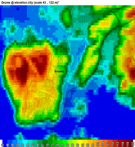
Below is the Elevation map of Grums, which displays elevation range with different colors. Scale of the first map is from 43 to 122 m (141 to 400 ft) with average elevation of 67.8 meters (=222 ft) [note 1]
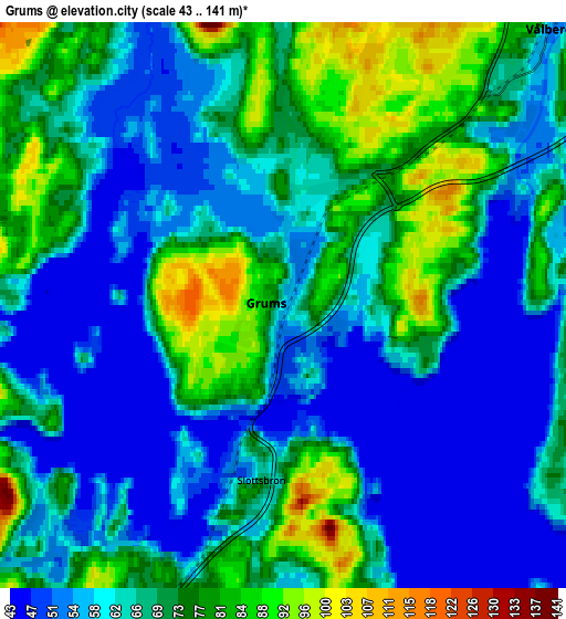
These maps also provides idea of topography and contour of this city, they are displayed at different zoom levels. More info about maps, scale and edge coordinates you can find below images.
| \ | Map #1 | Map #2 | Topo.Map |
| Scale [m] | 43..122 m | 43..141 m | × |
| Scale [ft] | 141..400 ft | 141..463 ft | × |
| Average | 67.8 m = 222 ft | 65.9 m = 216 ft | × |
| Width | 4.98 km = 3.1 mi | 9.96 km = 6.2 mi | 159.4 km = 99 mi |
| Height | 4.98 km = 3.1 mi | 9.96 km = 6.2 mi | 159.4 km = 99 mi |
| ↑Max Latitude | 59.373805° | 59.396185° | 60.06074° |
| Latitude at center | 59.35141° | 59.35141° | 59.35141° |
| ↓Min Latitude | 59.329001° | 59.306576° | 58.62694° |
| ← Min Longitude | 13.067105° | 13.023159° | 11.7048° |
| Longitude center | 13.11105° | 13.11105° | 13.11105° |
| →Max Longitude | 13.154995° | 13.198941° | 14.5173° |
Nearby cities:
Cities around Grums sort by population:
• Karlstad elevation 58 m
22.5 km,  82°
82°
• Skoghall 56 m
20.3 km,  98°
98°
• Åmål 52 m
40.6 km,  214°
214°
• Säffle 60 m
26.5 km,  203°
203°
• Kil 101 m
20.3 km,  34°
34°
• Forshaga 63 m
28.5 km,  47°
47°
• Skåre 52 m
20.4 km,  63°
63°
• Råtorp 53 m
22.3 km, 75°
• Vålberg 68 m
6.2 km,  43°
43°
• Deje 78 m
34.6 km, 36°
• Skattkärr 63 m
32.4 km, 77°
• Slottsbron 68 m
3.2 km,  188°
188°
Multilingual:
 En español:
Grums elevación 64 m.
 En France:
Grums élévation 64 m.


Sources and notes:
- [note 1] Map square and city borders are not equal. Map elevation data is calculated only from area inside that square.
- [src 1] Elevation data from geonames database provided with same terms of usage.
- [src 2] The elevation map of Grums is generated using elevation data from NASA's 3 arcsec (90m) resolution SRTM data.
- [src 3] Base (background) map © OpenStreetMap contributors tiles are generated by Geofabrik and OpenTopoMap.
Copyright & License:
This Grums Elevation Map is licensed under CC BY-SA. You may reuse any part from this page, if you give a proper credit by linking to this URL:
 More info on terms of use page.