Huskvarna elevation
Huskvarna (Jönköping, Jönköpings Kommun), Sweden elevation is 217 meters and Huskvarna elevation in feet is 712 ft above sea level [src 1]. Huskvarna is a populated place (feature code) with elevation that is 142 meters (466 ft) bigger than average city elevation in Sweden.
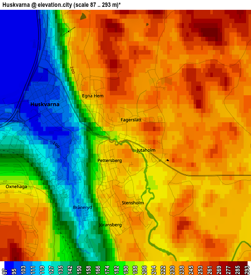
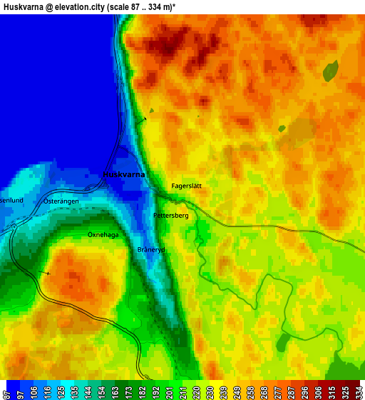
Below is the Elevation map of Huskvarna, which displays elevation range with different colors. Scale of the first map is from 87 to 293 m (285 to 961 ft) with average elevation of 203.8 meters (=669 ft) [note 1]
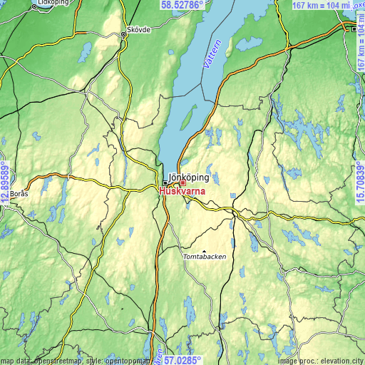
These maps also provides idea of topography and contour of this city, they are displayed at different zoom levels. More info about maps, scale and edge coordinates you can find below images.
| \ | Map #1 | Map #2 | Topo.Map |
| Scale [m] | 87..293 m | 87..334 m | × |
| Scale [ft] | 285..961 ft | 285..1096 ft | × |
| Average | 203.8 m = 669 ft | 208.1 m = 683 ft | × |
| Width | 5.21 km = 3.2 mi | 10.42 km = 6.5 mi | 166.7 km = 103.6 mi |
| Height | 5.21 km = 3.2 mi | 10.42 km = 6.5 mi | 166.7 km = 103.6 mi |
| ↑Max Latitude | 57.809379° | 57.832783° | 58.52786° |
| Latitude at center | 57.78596° | 57.78596° | 57.78596° |
| ↓Min Latitude | 57.762526° | 57.739077° | 57.0285° |
| ← Min Longitude | 14.258195° | 14.214249° | 12.89589° |
| Longitude center | 14.30214° | 14.30214° | 14.30214° |
| →Max Longitude | 14.346085° | 14.390031° | 15.70839° |
Nearby cities:
Cities around Huskvarna sort by population:
• Jönköping elevation 100 m
8.7 km,  266°
266°
• Nässjö 303 m
27.7 km,  122°
122°
• Bankeryd 116 m
13.4 km,  308°
308°
• Habo 182 m
19.4 km,  316°
316°
• Taberg 221 m
17.5 km,  226°
226°
• Tenhult 230 m
8.8 km,  172°
172°
• Gränna 203 m
27.4 km,  20°
20°
• Odensjö 180 m
11.1 km, 226°
• Forserum 277 m
13.7 km,  134°
134°
• Kaxholmen 191 m
7.5 km,  1°
1°
• Hestra 286 m
22.1 km,  48°
48°
• Malmbäck 285 m
25.1 km,  157°
157°
Multilingual:
 En español:
Huskvarna elevación 217 m.
 En France:
Huskvarna élévation 217 m.
 Auf Deutsch:
Huskvarna höhe über dem Meeresspiegel ist 217 m.

Sources and notes:
- [note 1] Map square and city borders are not equal. Map elevation data is calculated only from area inside that square.
- [src 1] Elevation data from geonames database provided with same terms of usage.
- [src 2] The elevation map of Huskvarna is generated using elevation data from NASA's 3 arcsec (90m) resolution SRTM data.
- [src 3] Base (background) map © OpenStreetMap contributors tiles are generated by Geofabrik and OpenTopoMap.
Copyright & License:
This Huskvarna Elevation Map is licensed under CC BY-SA. You may reuse any part from this page, if you give a proper credit by linking to this URL:
 More info on terms of use page.