Habo elevation
Habo (Jönköping, Habo Kommun), Sweden elevation is 182 meters and Habo elevation in feet is 597 ft above sea level [src 1]. Habo is a seat of a second-order administrative division (feature code) with elevation that is 107 meters (351 ft) bigger than average city elevation in Sweden.
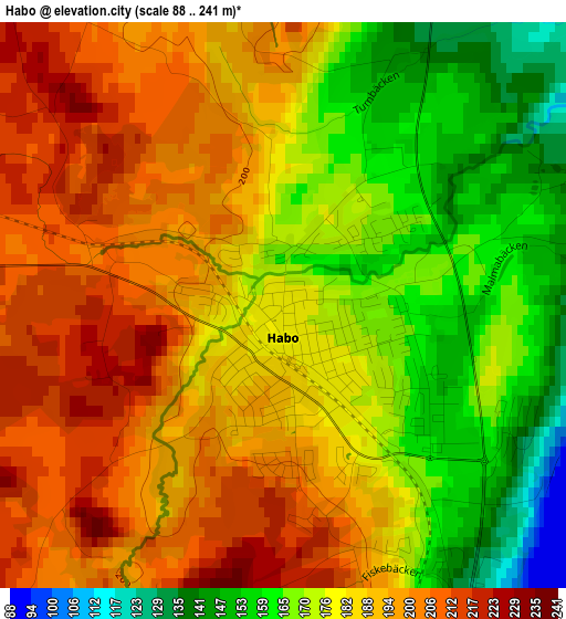
Below is the Elevation map of Habo, which displays elevation range with different colors. Scale of the first map is from 88 to 241 m (289 to 791 ft) with average elevation of 183.3 meters (=601 ft) [note 1]
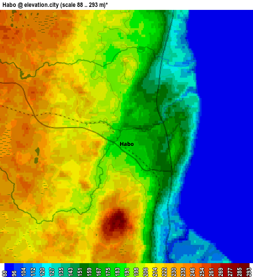
These maps also provides idea of topography and contour of this city, they are displayed at different zoom levels. More info about maps, scale and edge coordinates you can find below images.
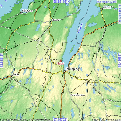
| \ | Map #1 | Map #2 | Topo.Map |
| Scale [m] | 88..241 m | 88..293 m | × |
| Scale [ft] | 289..791 ft | 289..961 ft | × |
| Average | 183.3 m = 601 ft | 173.3 m = 569 ft | × |
| Width | 5.19 km = 3.2 mi | 10.38 km = 6.4 mi | 166.1 km = 103.2 mi |
| Height | 5.19 km = 3.2 mi | 10.38 km = 6.4 mi | 166.1 km = 103.2 mi |
| ↑Max Latitude | 57.935187° | 57.958509° | 58.65115° |
| Latitude at center | 57.91185° | 57.91185° | 57.91185° |
| ↓Min Latitude | 57.888498° | 57.86513° | 57.15702° |
| ← Min Longitude | 14.030495° | 13.986549° | 12.66819° |
| Longitude center | 14.07444° | 14.07444° | 14.07444° |
| →Max Longitude | 14.118385° | 14.162331° | 15.48069° |
Nearby cities:
Cities around Habo sort by population:
• Jönköping elevation 100 m
15.3 km,  161°
161°
• Huskvarna 217 m
19.4 km,  136°
136°
• Bankeryd 116 m
6.4 km,  152°
152°
• Tidaholm 148 m
30.6 km,  347°
347°
• Mullsjö 256 m
11.6 km,  272°
272°
• Taberg 221 m
26.1 km,  178°
178°
• Tenhult 230 m
27 km, 147°
• Gränna 203 m
25.9 km,  63°
63°
• Odensjö 180 m
22.4 km,  165°
165°
• Forserum 277 m
33.1 km, 135°
• Kaxholmen 191 m
15.1 km,  115°
115°
• Hestra 286 m
30.1 km,  88°
88°
Multilingual:
 En español:
Habo elevación 182 m.
 En France:
Habo élévation 182 m.


Sources and notes:
- [note 1] Map square and city borders are not equal. Map elevation data is calculated only from area inside that square.
- [src 1] Elevation data from geonames database provided with same terms of usage.
- [src 2] The elevation map of Habo is generated using elevation data from NASA's 3 arcsec (90m) resolution SRTM data.
- [src 3] Base (background) map © OpenStreetMap contributors tiles are generated by Geofabrik and OpenTopoMap.
Copyright & License:
This Habo Elevation Map is licensed under CC BY-SA. You may reuse any part from this page, if you give a proper credit by linking to this URL:
 More info on terms of use page.