Nässjö elevation
Nässjö (Jönköping, Nässjö Kommun), Sweden elevation is 303 meters and Nässjö elevation in feet is 994 ft above sea level [src 1]. Nässjö is a seat of a second-order administrative division (feature code) with elevation that is 228 meters (748 ft) bigger than average city elevation in Sweden.
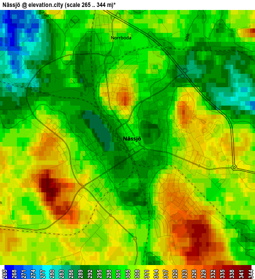
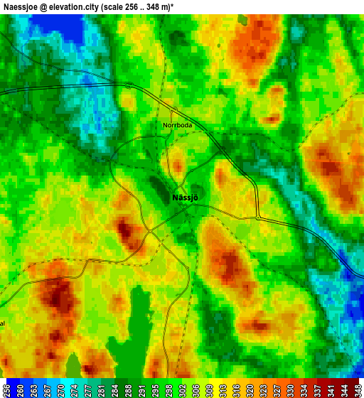
Below is the Elevation map of Nässjö, which displays elevation range with different colors. Scale of the first map is from 265 to 344 m (869 to 1129 ft) with average elevation of 304.1 meters (=998 ft) [note 1]
These maps also provides idea of topography and contour of this city, they are displayed at different zoom levels. More info about maps, scale and edge coordinates you can find below images.
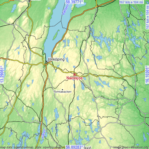
| \ | Map #1 | Map #2 | Topo.Map |
| Scale [m] | 265..344 m | 256..348 m | × |
| Scale [ft] | 869..1129 ft | 840..1142 ft | × |
| Average | 304.1 m = 998 ft | 301.5 m = 989 ft | × |
| Width | 5.23 km = 3.2 mi | 10.46 km = 6.5 mi | 167.3 km = 104 mi |
| Height | 5.23 km = 3.2 mi | 10.46 km = 6.5 mi | 167.3 km = 104 mi |
| ↑Max Latitude | 57.676575° | 57.700065° | 58.39771° |
| Latitude at center | 57.65307° | 57.65307° | 57.65307° |
| ↓Min Latitude | 57.62955° | 57.606014° | 56.89283° |
| ← Min Longitude | 14.652815° | 14.608869° | 13.29051° |
| Longitude center | 14.69676° | 14.69676° | 14.69676° |
| →Max Longitude | 14.740705° | 14.784651° | 16.10301° |
Nearby cities:
Cities around Nässjö sort by population:
• Huskvarna elevation 217 m
27.7 km,  302°
302°
• Eksjö 215 m
16.4 km,  84°
84°
• Sävsjö 226 m
27.9 km,  184°
184°
• Aneby 223 m
21.7 km,  18°
18°
• Tenhult 230 m
23.1 km,  285°
285°
• Odensjö 180 m
32.3 km,  282°
282°
• Forserum 277 m
14.6 km, 290°
• Bodafors 276 m
17 km, 179°
• Ekenässjön 227 m
26.4 km,  132°
132°
• Kaxholmen 191 m
32.2 km,  313°
313°
• Hestra 286 m
30.1 km,  347°
347°
• Malmbäck 285 m
16.4 km,  238°
238°
Multilingual:
 En español:
Nässjö elevación 303 m.
 En France:
Nässjö élévation 303 m.


Sources and notes:
- [note 1] Map square and city borders are not equal. Map elevation data is calculated only from area inside that square.
- [src 1] Elevation data from geonames database provided with same terms of usage.
- [src 2] The elevation map of Nässjö is generated using elevation data from NASA's 3 arcsec (90m) resolution SRTM data.
- [src 3] Base (background) map © OpenStreetMap contributors tiles are generated by Geofabrik and OpenTopoMap.
Copyright & License:
This Nässjö Elevation Map is licensed under CC BY-SA. You may reuse any part from this page, if you give a proper credit by linking to this URL:
 More info on terms of use page.