Abū Zabad elevation
Abū Zabad (West Kordofan State), Sudan elevation is 559 meters and Abū Zabad elevation in feet is 1834 ft above sea level [src 1]. Abū Zabad is a populated place (feature code) with elevation that is 110 meters (361 ft) bigger than average city elevation in Sudan.
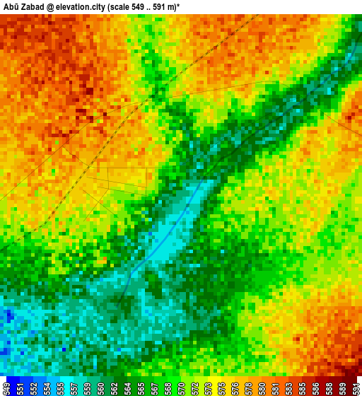
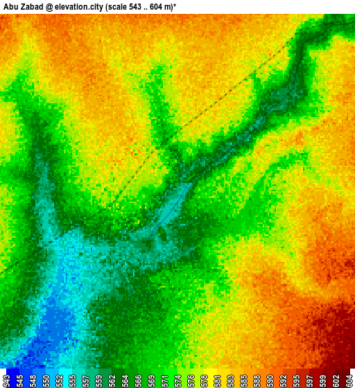
Below is the Elevation map of Abū Zabad, which displays elevation range with different colors. Scale of the first map is from 549 to 591 m (1801 to 1939 ft) with average elevation of 570.6 meters (=1872 ft) [note 1]
These maps also provides idea of topography and contour of this city, they are displayed at different zoom levels. More info about maps, scale and edge coordinates you can find below images.
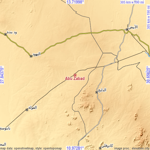
| \ | Map #1 | Map #2 | Topo.Map |
| Scale [m] | 549..591 m | 543..604 m | × |
| Scale [ft] | 1801..1939 ft | 1781..1982 ft | × |
| Average | 570.6 m = 1872 ft | 574.4 m = 1885 ft | × |
| Width | 9.55 km = 5.9 mi | 19.09 km = 11.9 mi | 305.5 km = 189.8 mi |
| Height | 9.55 km = 5.9 mi | 19.09 km = 11.9 mi | 305.5 km = 189.8 mi |
| ↑Max Latitude | 12.392925° | 12.435843° | 13.71998° |
| Latitude at center | 12.35° | 12.35° | 12.35° |
| ↓Min Latitude | 12.307068° | 12.264129° | 10.97281° |
| ← Min Longitude | 29.206055° | 29.162109° | 27.84375° |
| Longitude center | 29.25° | 29.25° | 29.25° |
| →Max Longitude | 29.293945° | 29.337891° | 30.65625° |
Nearby cities:
Cities around Abū Zabad sort by population:
• El Obeid elevation 573 m
140 km,  48°
48°
• An Nuhūd 571 m
96.8 km,  293°
293°
• Kadugli 506 m
157.4 km,  161°
161°
• Umm Ruwaba 457 m
222.1 km,  73°
73°
• Dilling 687 m
54.8 km,  127°
127°
• Ar Rahad 506 m
157.3 km, 74°
• Al Mijlad 434 m
220.7 km,  228°
228°
• Bārah 478 m
192.8 km,  38°
38°
• Talodi 485 m
227.2 km,  147°
147°
• Al Fūlah 519 m
118.8 km, 234°
• Al Lagowa 566 m
106.4 km,  186°
186°
• El Fula 517 m
121.2 km, 234°
Multilingual:
 En español:
Abū Zabad elevación 559 m.
 En France:
Abū Zabad élévation 559 m.
 Auf Deutsch:
Abū Zabad höhe über dem Meeresspiegel ist 559 m.

Sources and notes:
- [note 1] Map square and city borders are not equal. Map elevation data is calculated only from area inside that square.
- [src 1] Elevation data from geonames database provided with same terms of usage.
- [src 2] The elevation map of Abū Zabad is generated using elevation data from NASA's 3 arcsec (90m) resolution SRTM data.
- [src 3] Base (background) map © OpenStreetMap contributors tiles are generated by Geofabrik and OpenTopoMap.
Copyright & License:
This Abū Zabad Elevation Map is licensed under CC BY-SA. You may reuse any part from this page, if you give a proper credit by linking to this URL:
 More info on terms of use page.