El Obeid elevation
El Obeid (North Kordofan), Sudan elevation is 573 meters and El Obeid elevation in feet is 1880 ft above sea level [src 1]. El Obeid is a seat of a first-order administrative division (feature code) with elevation that is 124 meters (407 ft) bigger than average city elevation in Sudan.
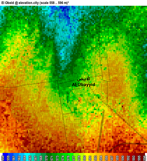
Below is the Elevation map of El Obeid, which displays elevation range with different colors. Scale of the first map is from 558 to 596 m (1831 to 1955 ft) with average elevation of 578.6 meters (=1898 ft) [note 1]
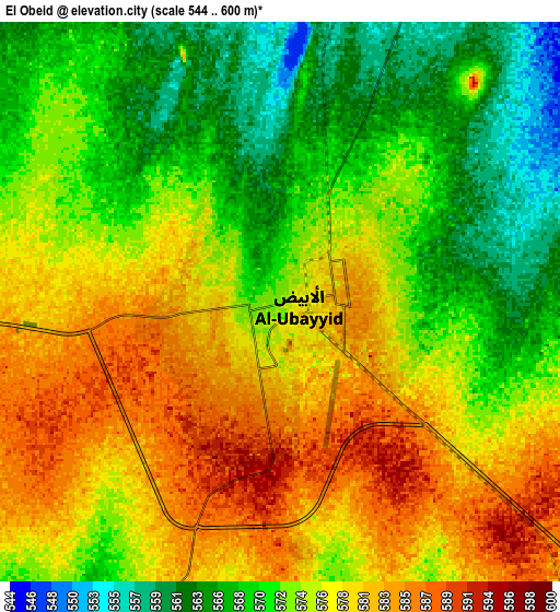
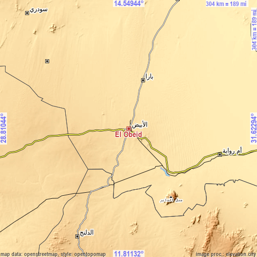
These maps also provides idea of topography and contour of this city, they are displayed at different zoom levels. More info about maps, scale and edge coordinates you can find below images.
| \ | Map #1 | Map #2 | Topo.Map |
| Scale [m] | 558..596 m | 544..600 m | × |
| Scale [ft] | 1831..1955 ft | 1785..1969 ft | × |
| Average | 578.6 m = 1898 ft | 574.5 m = 1885 ft | × |
| Width | 9.51 km = 5.9 mi | 19.03 km = 11.8 mi | 304.5 km = 189.2 mi |
| Height | 9.51 km = 5.9 mi | 19.03 km = 11.8 mi | 304.5 km = 189.2 mi |
| ↑Max Latitude | 13.226993° | 13.269769° | 14.54944° |
| Latitude at center | 13.18421° | 13.18421° | 13.18421° |
| ↓Min Latitude | 13.141419° | 13.098621° | 11.81132° |
| ← Min Longitude | 30.172745° | 30.128799° | 28.81044° |
| Longitude center | 30.21669° | 30.21669° | 30.21669° |
| →Max Longitude | 30.260635° | 30.304581° | 31.62294° |
Nearby cities:
Cities around El Obeid sort by population:
• An Nuhūd elevation 571 m
200.6 km,  254°
254°
• Ad Douiem 385 m
243.9 km,  68°
68°
• Umm Ruwaba 457 m
112.6 km,  105°
105°
• Dilling 687 m
140.3 km,  205°
205°
• Tandaltī 422 m
179.7 km,  95°
95°
• Ar Rahad 506 m
70.1 km,  137°
137°
• Abu Jibeha 573 m
221.4 km,  150°
150°
• Bārah 478 m
59.6 km,  15°
15°
• Abū Zabad 559 m
140 km,  228°
228°
• Marabba 401 m
232.6 km, 113°
• Al Lagowa 566 m
230.7 km, 210°
• Um Jar Al Gharbiyya 384 m
246.6 km, 73°
Multilingual:
 En español:
El Obeid elevación 573 m.
 En France:
El Obeid élévation 573 m.
 Auf Deutsch:
Al-Ubayyid höhe über dem Meeresspiegel ist 573 m.

Sources and notes:
- [note 1] Map square and city borders are not equal. Map elevation data is calculated only from area inside that square.
- [src 1] Elevation data from geonames database provided with same terms of usage.
- [src 2] The elevation map of El Obeid is generated using elevation data from NASA's 3 arcsec (90m) resolution SRTM data.
- [src 3] Base (background) map © OpenStreetMap contributors tiles are generated by Geofabrik and OpenTopoMap.
Copyright & License:
This El Obeid Elevation Map is licensed under CC BY-SA. You may reuse any part from this page, if you give a proper credit by linking to this URL:
 More info on terms of use page.