Talodi elevation
Talodi (Southern Kordofan), Sudan elevation is 485 meters and Talodi elevation in feet is 1591 ft above sea level [src 1]. Talodi is a populated place (feature code) with elevation that is 36 meters (118 ft) bigger than average city elevation in Sudan.
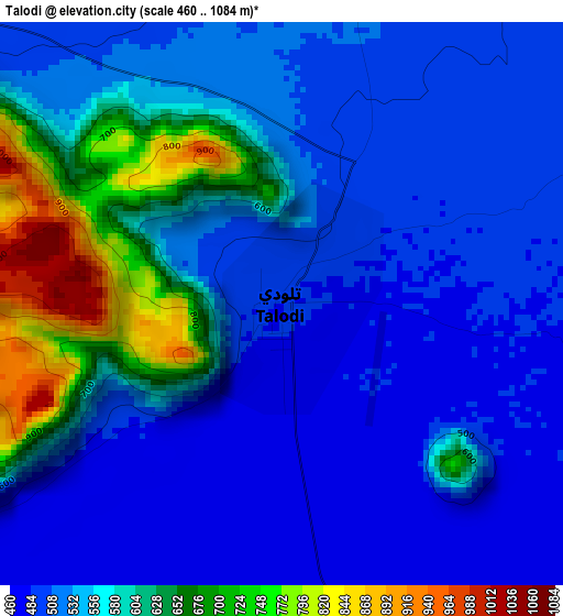
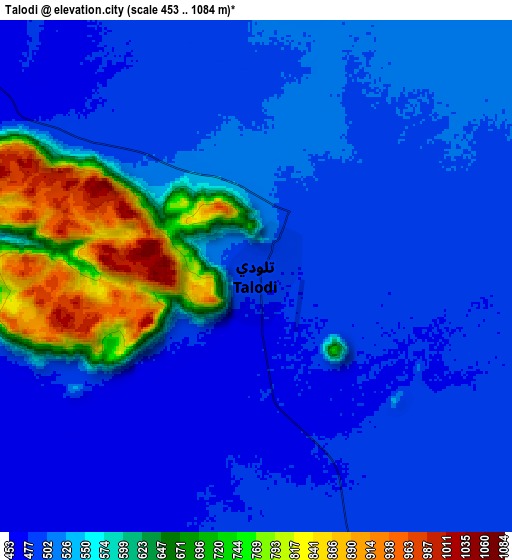
Below is the Elevation map of Talodi, which displays elevation range with different colors. Scale of the first map is from 460 to 1084 m (1509 to 3556 ft) with average elevation of 554.8 meters (=1820 ft) [note 1]
These maps also provides idea of topography and contour of this city, they are displayed at different zoom levels. More info about maps, scale and edge coordinates you can find below images.
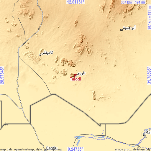
| \ | Map #1 | Map #2 | Topo.Map |
| Scale [m] | 460..1084 m | 453..1084 m | × |
| Scale [ft] | 1509..3556 ft | 1486..3556 ft | × |
| Average | 554.8 m = 1820 ft | 543 m = 1781 ft | × |
| Width | 9.6 km = 6 mi | 19.21 km = 11.9 mi | 307.3 km = 190.9 mi |
| Height | 9.6 km = 6 mi | 19.21 km = 11.9 mi | 307.4 km = 191 mi |
| ↑Max Latitude | 10.675648° | 10.718829° | 12.01131° |
| Latitude at center | 10.63246° | 10.63246° | 10.63246° |
| ↓Min Latitude | 10.589266° | 10.546066° | 9.24735° |
| ← Min Longitude | 30.335755° | 30.291809° | 28.97345° |
| Longitude center | 30.3797° | 30.3797° | 30.3797° |
| →Max Longitude | 30.423645° | 30.467591° | 31.78595° |
Nearby cities:
Cities around Talodi sort by population:
• El Obeid elevation 573 m
284.3 km,  356°
356°
• Kadugli 506 m
83.6 km,  300°
300°
• Umm Ruwaba 457 m
268.7 km,  19°
19°
• Dilling 687 m
176.6 km,  333°
333°
• Ar Rahad 506 m
233.6 km,  7°
7°
• Abu Jibeha 573 m
130.3 km,  45°
45°
• Al Mijlad 434 m
292.4 km,  278°
278°
• Abū Zabad 559 m
227.2 km, 327°
• Marabba 401 m
274 km, 45°
• Al Fūlah 519 m
252.2 km, 299°
• Al Lagowa 566 m
160.6 km, 302°
• El Fula 517 m
252.2 km, 298°
Multilingual:
 En español:
Talodi elevación 485 m.
 En France:
Talodi élévation 485 m.


Sources and notes:
- [note 1] Map square and city borders are not equal. Map elevation data is calculated only from area inside that square.
- [src 1] Elevation data from geonames database provided with same terms of usage.
- [src 2] The elevation map of Talodi is generated using elevation data from NASA's 3 arcsec (90m) resolution SRTM data.
- [src 3] Base (background) map © OpenStreetMap contributors tiles are generated by Geofabrik and OpenTopoMap.
Copyright & License:
This Talodi Elevation Map is licensed under CC BY-SA. You may reuse any part from this page, if you give a proper credit by linking to this URL:
 More info on terms of use page.