Chebarkul’ elevation
Chebarkul’ (Chelyabinsk, Chebarkul’skiy Rayon), Russia elevation is 329 meters and Chebarkul’ elevation in feet is 1079 ft above sea level [src 1]. Chebarkul’ is a populated place (feature code) with elevation that is 130 meters (427 ft) bigger than average city elevation in Russia.
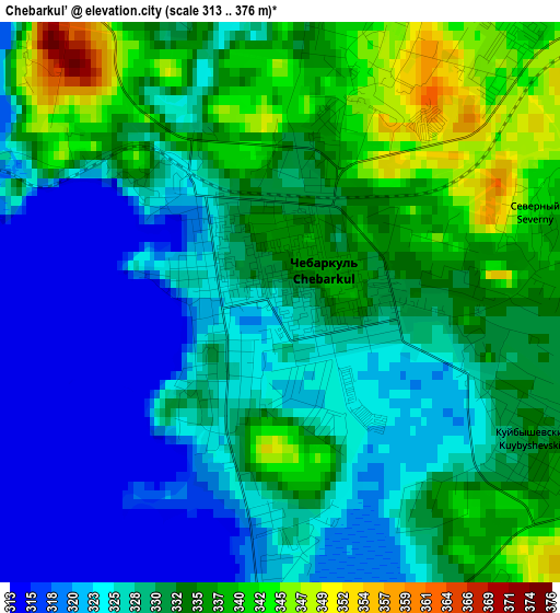
Below is the Elevation map of Chebarkul’, which displays elevation range with different colors. Scale of the first map is from 313 to 376 m (1027 to 1234 ft) with average elevation of 329.9 meters (=1082 ft) [note 1]
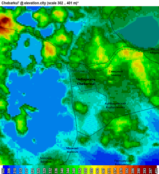
These maps also provides idea of topography and contour of this city, they are displayed at different zoom levels. More info about maps, scale and edge coordinates you can find below images.
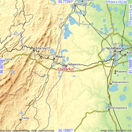
| \ | Map #1 | Map #2 | Topo.Map |
| Scale [m] | 313..376 m | 302..401 m | × |
| Scale [ft] | 1027..1234 ft | 991..1316 ft | × |
| Average | 329.9 m = 1082 ft | 329.5 m = 1081 ft | × |
| Width | 5.61 km = 3.5 mi | 11.22 km = 7 mi | 179.5 km = 111.5 mi |
| Height | 5.61 km = 3.5 mi | 11.22 km = 7 mi | 179.5 km = 111.5 mi |
| ↑Max Latitude | 55.000114° | 55.025312° | 55.77391° |
| Latitude at center | 54.9749° | 54.9749° | 54.9749° |
| ↓Min Latitude | 54.94967° | 54.924425° | 54.15967° |
| ← Min Longitude | 60.319355° | 60.275409° | 58.95705° |
| Longitude center | 60.3633° | 60.3633° | 60.3633° |
| →Max Longitude | 60.407245° | 60.451191° | 61.76955° |
Nearby cities:
Cities around Chebarkul’ sort by population:
• Zlatoust elevation 548 m
50.3 km,  295°
295°
• Miass 341 m
18 km, 295°
• Karabash 347 m
57 km,  350°
350°
• Poletayevo 244 m
48.3 km,  82°
82°
• Magnitka 386 m
59.3 km,  314°
314°
• Yemanzhelinka 240 m
62.9 km,  107°
107°
• Koyelga 235 m
49.9 km,  135°
135°
• Timiryazevskiy 296 m
26 km,  101°
101°
• Turgoyak 333 m
24.9 km,  321°
321°
• Sargazy 263 m
56.8 km, 84°
• Leninsk 404 m
32.7 km,  255°
255°
• Syrostan 386 m
31.1 km,  288°
288°
Multilingual:
 En español:
Chebarkul’ elevación 329 m.
 En France:
Chebarkul’ élévation 329 m.
 Auf Deutsch:
Chebarkul’ höhe über dem Meeresspiegel ist 329 m.

Sources and notes:
- [note 1] Map square and city borders are not equal. Map elevation data is calculated only from area inside that square.
- [src 1] Elevation data from geonames database provided with same terms of usage.
- [src 2] The elevation map of Chebarkul’ is generated using elevation data from NASA's 3 arcsec (90m) resolution SRTM data.
- [src 3] Base (background) map © OpenStreetMap contributors tiles are generated by Geofabrik and OpenTopoMap.
Copyright & License:
This Chebarkul’ Elevation Map is licensed under CC BY-SA. You may reuse any part from this page, if you give a proper credit by linking to this URL:
 More info on terms of use page.